Coral Reefs / Tropically Fish from Oceans / Creative / Environment Creation Constructive / HTTP://www.andreaspennophotography.de @ A.P. P / Portrayal / Update 24.07.2025 AD n.Chr


What are Coral Reefs ?
Appearing as solitary forms in the fossil record more than 400 million years ago, corals are extremely ancient animals that evolved into modern reef-building forms over the last 25 million years. Coral reefs are unique (e.g., the largest structures on earth of biological origin) and complex systems. Rivaling old growth forests in longevity of their ecological communities, well-developed reefs reflect thousands of years of history (Turgeon and Asch, in press).
Corals and their Kind
Corals are anthozoans, the largest class of organisms within the phylum Cnidaria. Comprising over 6,000 known species, anthozoans also include sea fans, sea pansies and anemones. Stony corals (scleractinians) make up the largest order of anthozoans, and are the group primarily responsible for laying the foundations of, and building up, reef structures. For the most part, scleractinians are colonial organisms composed of hundreds to hundreds of thousands of individuals, called polyps (Barnes, R.D., 1987; Lalli and Parsons, 1995).
As members of the phylum Cnidaria, corals have only a limited degree of organ development. Each polyp consists of three basic tissue layers: an outer epidermis, an inner layer of cells lining the gastrovascular cavity which acts as an internal space for digestion, and a layer called the mesoglea in between (Barnes, R.D., 1987).
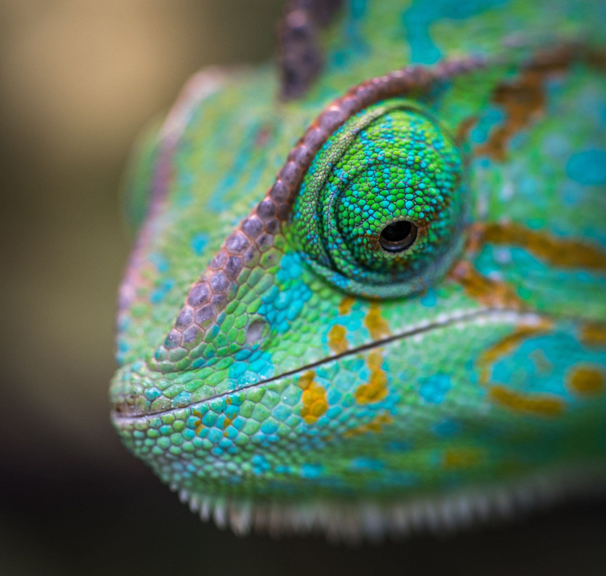
Structure of a typical coral polyp. All coral polyps share two basic structural features with other members of their phylum. The first is a gastrovascular cavity that opens at only one end. At the opening to this cavity, commonly called the mouth, food is consumed and some waste products are expelled. A second feature all corals possess is a circle of tentacles, extensions of the body wall that surround the mouth. Tentacles help the coral to capture and ingest plankton for food, clear away debris from the mouth, and act as the animal’s primary means of defense (Barnes, R.D., 1987; Levinton, 1995).
While coral polyps have structurally simple body plans, they possess several distinctive cellular structures. One of these is called a cnidocyte—a type of cell unique to, and characteristic of, all cnidarians. Found throughout the tentacles and epidermis, cnidocytes contain organelles called cnidae, which include nematocysts, a type of stinging cell. Because nematocytes are capable of delivering powerful, often lethal toxins, they are essential to capturing prey, and facilitate coralline agonistic interactions (Barnes, R.D., 1987).
Most corals, like other cnidarians, contain a symbiotic algae called zooxanthellae, within their gastrodermal cells. The coral provides the algae with a protected environment and the compounds necessary for photosynthesis. These include carbon dioxide, produced by coral respiration, and inorganic nutrients such as nitrates, and phosphates, which are metabolic waste products of the coral. In return, the algae produce oxygen and help the coral to remove wastes. Most importantly, they supply the coral with organic products of photosynthesis. These compounds, including glucose, glycerol, and amino acids, are utilized by the coral as building blocks in the manufacture of proteins, fats, and carbohydrates, as well as the synthesis of calcium carbonate (CaCO3). The mutual exchange of algal photosynthates and cnidarian metabolites is the key to the prodigious biological productivity and limestone-secreting capacity of reef building corals (Barnes, R.D., 1987; Barnes, R.S.K. and Hughes, 1999; Lalli and Parsons, 1995; Levinton, 1995; Sumich, 1996).
Zooxanthellae often are critical elements in the continuing health of reef-building corals. As much as 90% of the organic material they manufacture photosynthetically is transferred to the host coral tissue (Sumich, 1996). If these algal cells are expelled by the polyps, which can occur if the colony undergoes prolonged physiological stress, the host may die shortly afterwards. The symbiotic zooxanthellae also confers its color to the polyp. If the zooxanthellae are expelled, the colony takes on a stark white appearance, which is commonly described as “coral bleaching” (Barnes, R.S.K. and Hughes, 1999; Lalli and Parsons, 1995).
Massive reef structures are formed when each stony coral polyp secretes a skeleton of CaCO3. Most stony corals have very small polyps, averaging 1 to 3 mm in diameter, but entire colonies can grow very large and weigh several tons. Although all corals secrete CaCO3, not all are reef builders. Some corals, such as Fungia sp., are solitary and have single polyps that can grow as large as 25 cm in diameter. Other coral species are incapable of producing sufficient quantities of CaCO3 to form reefs. Many of these corals do not rely on the algal metabolites produced by zooxanthellae, and live in deeper and/or colder waters beyond the geographic range of most reef systems (Barnes, R.D., 1987; Sumich, 1996).
The skeletons of stony corals are secreted by the lower portion of the polyp. This process produces a cup, called the calyx, in which the polyp sits. The walls surrounding the cup are called the theca, and the floor is called the basal plate. Thin, calcareous septa (sclerosepta), which provide structural integrity, protection, and an increased surface area for the polyp’s soft tissues, extend upward from the basal plate and radiate outward from its center. Periodically, a polyp will lift off its base and secrete a new floor to its cup, forming a new basal plate above the old one. This creates a minute chamber in the skeleton. While the colony is alive, CaCO3 is deposited, adding partitions and elevating the coral. When polyps are physically stressed, they contract into the calyx so that virtually no part is exposed above the skeletal platform. This protects the organism from predators and the elements (Barnes, R.D., 1987; Sumich, 1996).
lli and Parsons, 1995; Sumich, 1996).


Major coral reef sites are seen as red dots on this world map. Most of the reefs, with a few exceptions are found in tropical and semitropical waters, between 30° north and 30° south latitudes.
At other times, the polyp extends out of the calyx. The timing and extent to which a polyp extends from its protective skeleton often depends on the time of the day, as well as the species of coral. Most polyps extend themselves furthest when they feed on plankton at night.
In addition to a substantial horizontal component, the polyps of colonial corals are connected laterally to their neighbors by a thin horizontal sheet of tissue called the coenosarc, which covers the limestone between the calyxes. Together, polyps and coenosarc constitute a thin layer of living tissue over the block of limestone they have secreted. Thus, the living colony lies entirely above the skeleton (Barnes, R.S.K. and Hughes, 1999).
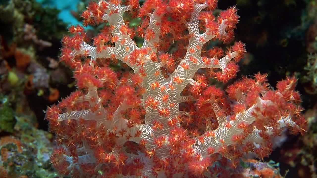
Colonies of reef-building (hermatypic) corals exhibit a wide range of shapes, but most can be classified within ten general forms. Branching corals have branches that also have (secondary) branches. Digitate corals look like fingers or clumps of cigars and have no secondary branches. Table corals are table-like structures of fused branches. Elkhorn coral has large, flattened branches. Foliose corals have broad plate-like portions rising above the substrate. Encrusting corals grow as a thin layer against the substrate. Submassive corals have knobs, columns or wedges protruding from an encrusting base. Massive corals are ball-shaped or boulder-like corals which may be small as an egg or large as a house. Mushroom corals resemble the attached or unattached tops of mushrooms. Cup corals look like egg cups or cups that have been squashed, elongated or twisted (McManus et al. 1997). While the growth patterns of stony coral colonies are primarily species-specific, a colony’s geographic location, environmental factors (e.g., wave action, temperature, light exposure), and the density of surrounding corals may affect and/or alter the shape of the colony as it grows (Barnes, R.D. 1987; Barnes, R.S.K. and Hughes 1999, Lalli and Parsons, 1995).
In addition to affecting the shape of a colony’s growth, environmental factors influence the rates at which various species of corals grow. One of the most significant factors is sunlight. On sunny days, the calcification rates of corals can be twice as fast as on cloudy days (Barnes, R.S.K. and Hughes, 1999). This is likely a function of the symbiotic zooxanthellae algae, which play a unique role in enhancing the corals’ ability to synthesize calcium carbonate. Experiments have shown that rates of calcification slow significantly when zooxanthellae are removed from corals, or when corals are kept in shade or darkness (Lalli and Parsons 1995).
Image of coral core samples
Coral core samples reveal horizontal growth lines.
In general, massive corals tend to grow slowly, increasing in size from 0.5 cm to 2 cm per year. However, under favorable conditions (high light exposure, consistent temperature, moderate wave action), some species can grow as much as 4.5 cm per year. In contrast to the massive species, branching colonies tend to grow much faster. Under favorable conditions, these colonies can grow vertically by as much as 10 cm per year. This fast growth rate is not as advantageous as it may seem, however. Mechanical constraints limit the maximum size that branching corals can achieve. As they become larger, a heavier load is placed on the relatively small area attached to the substratum, rendering the colony increasingly unstable. Under these circumstances, the branches are prone to snapping off during strong wave action. The opposite is true of the massive-shaped corals, which become more stable as they grow larger (Barnes, R.S.K. and Hughes, 1999).
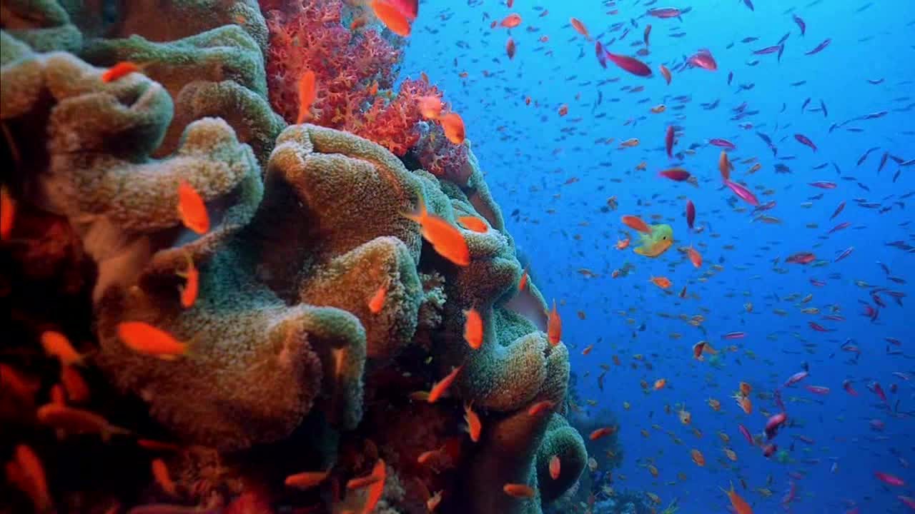
Reef-building corals are restricted in their geographic distribution. This is because the algal-cnidarian symbiotic machinery needs a narrow and consistent band of environmental conditions to produce the copious quantities of limestone necessary for reef formation. The formation of highly consolidated reefs only occur where the temperature does not fall below 18°C for extended periods of time. This specific temperature restriction -18°C- does not, however, apply to the corals themselves. In Japan, where this has been studied in detail, approximately half of all coral species occur where the sea temperature regularly falls to 14°C an approximately 25% occur where it falls to 11°C (Veron 2000). Many grow optimally in water temperatures between 23° and 29°C, but some can tolerate temperatures as high as 40°C for limited periods of time. Most require very salty (saline) water ranging from 32 to 42 parts per thousand. The water must also be clear to permit high light penetration. The corals’ requirement for high light also explains why most reef-building species are restricted to the euphotic (light penetration) zone, approximately 70 m (Lalli and Parsons, 1995).
Generally, there are about twice as many coral species in Pacific Ocean reefs, such as this Fagatele Bay reef, as in Atlantic Ocean reefs.
The number of species of corals on a reef declines rapidly in deeper water. High levels of suspended sediments can smother coral colonies, clogging their mouths which can impair feeding. Suspended sediments can also serve to decrease the depth to which light can penetrate. In colder regions, murkier waters, or at depths below 70 m, corals may still exist on hard substrates, but their capacity to secrete limestone is greatly reduced (Barnes, R.D., 1987).
In light of such stringent environmental restrictions, reefs generally are confined to tropical and semitropical waters. The diversity of reef corals, i.e., the number of species, decreases in higher latitudes up to about 30° north and south, beyond which reef corals are usually not found. Bermuda, at 32° north latitude, is an exception to this rule because it lies directly in the path of the Gulf Stream’s warming waters (Barnes, R.D., 1987).
Another factor that seems to affect the diversity of reef-building corals is the ocean in which they are located. At least 500 reef-building species are known to exist in the waters of the Indo-Pacific region. In comparison, the Atlantic Ocean contains approximately 62 known species. The fossil record shows that many species once found across the Atlantic, Pacific and Indian Oceans gradually went extinct in the Atlantic, where the affects of ice ages had strong impacts on the Caribbean area wherein most of the Atlantic reefs reside. Following the closure of the seaway between the Caribbean and the Pacific, several species of corals became restricted to the Caribbean (Veron 2000).
All three reef types—fringing, barrier and atoll—share similarities in their biogeographic profiles.Bottom topography, depth, wave and current strength, light, temperature, and suspended sediments all act to create characteristic horizontal and vertical zones of corals, algae and other species. While these zones vary according to the location and type of reef, the major divisions common to most reefs, as they move seaward from the shore, are the reef flat, reef crest or algal ridge, buttress zone, and seaward slope.
The reef flat, or back reef, is located on the sheltered side of the reef. It extends outward from the shore; and may be highly variable in character. Varying in width from 20 or 30 meters to more than a few thousand, the reef flat may range from only a few centimeters to a few meters deep, and large parts may be exposed at low tide. The substrate is formed of coral rock and loose sand. Beds of sea grasses often develop in the sandy regions, and both encrusting and filamentous algae are common.
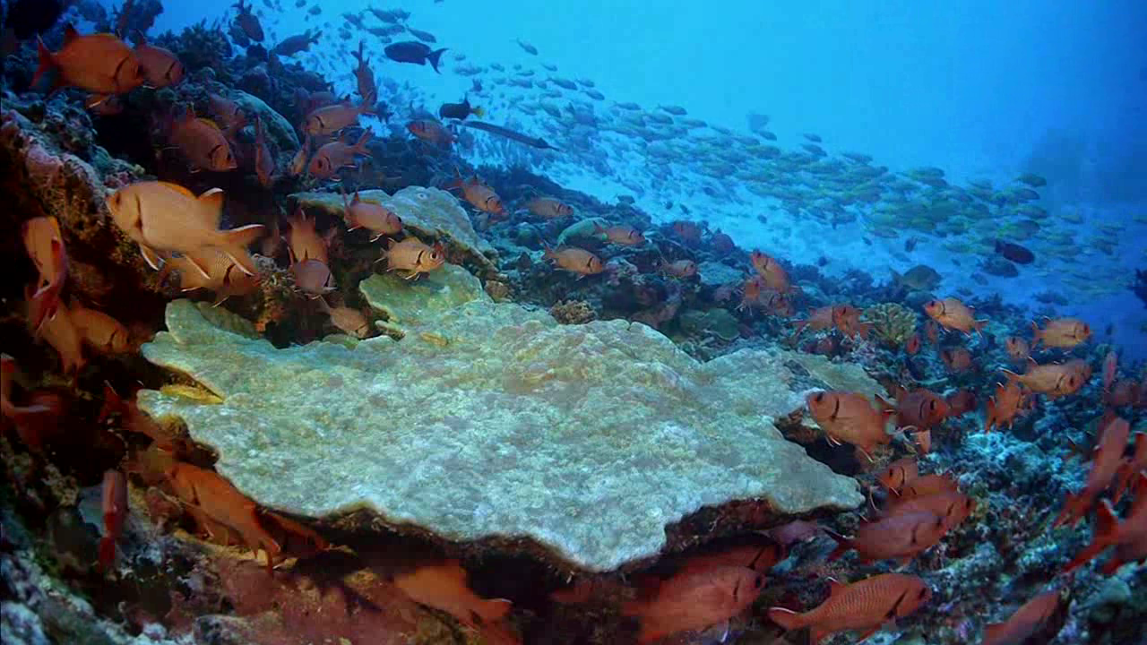
The reef crest, or algal ridge, is the highest point of the reef, and is exposed at low tide. Lying on the outer side of the reef, it is exposed to the full fury of incoming waves. The width of this zone typically varies from a few, to perhaps 50 m. In this severe habitat, a few species of encrusting calcareous red algae flourish, producing new reef material as rapidly as the waves erode it. Where wave action is severe, living corals are practically nonexistent, but in situations of more moderate wave action, the reef crest tends to be dominated by stoutly branching corals. These closely growing, robust colonies form ramparts able to withstand the heavy seas. Small crabs, shrimps, cowries and other animals reside in the labyrinthine subsurface cavities of the reef crest, protected from waves and predators (Barnes, R.D., 1987; Lalli and Parsons, 1995; Sumich, 1996).
The outermost seaward slope (also called the fore-reef) extends from the low-tide mark into deep water. Just below the low-tide mark to approximately 20 m depth is a rugged zone of spurs, or buttresses, radiating out from the reef. Deep channels that slope down the reef face are interspersed between the buttresses. These alternating spurs and channels may be several meters wide and up to 300 m long (Barnes, R.D. 1987; Lalli and Parsons, 1995; Sumich, 1996).
The buttress zone serves two main purposes in the reef system. First, it acts to dissipate the tremendous force of unabating waves and stabilizes the reef structure. Second, the channels between the buttresses drain debris and sediment off the reef and into deeper water. Massive corals and encrusting coralline algae thrive in this zone of breaking waves, intense sunlight, and abundant oxygen. Small fish inhabit the many holes and crevices on this portion of the reef, and many larger fish including sharks, jacks, barracudas and tunas patrol the buttresses and grooves in search of food (Barnes, R.D., 1987; Lalli and Parsons, 1995; Sumich, 1996).
The dropoff of a reef slope can extend hundreds of feet downward.
Continuing down the seaward slope to about 20 m, optimal light intensity decreases, but reduced wave action allows the maximum number of coral species to develop. Beginning at approximately 30 to 40 m, sediments accumulate on the gentle slope, and corals become patchy in distribution. Sponges, sea whips, sea fans, and ahermatypic (non-reef-building) corals become increasingly abundant and gradually replace hermatypic corals in deeper, darker water (Barnes, R.D., 1987; La

Whales on Planet Earth & Biosphere in the Ocean
The critically-endangered blue whale — the largest animal known to have ever existed — has returned to the waters near the remote island of South Georgia near Antarctica, almost 100 years after the mega-mammal was nearly made extinct by industrial whaling.
Researchers say a recent survey of the waters around the sub-Antarctic island — a center for industrial whaling until it was banned in the 1960s — recorded dozens of blue whales where only a single whale had been seen between 1998 and 2018.
"We've had indications in previous years that there might be more blue whales starting to come back to South Georgia," marine mammal ecologist Susannah Calderan told Live Science. "But we were very favorably surprised by quite how many we did see this year."
Calderan, a research fellow at the Scottish Association for Marine Science (SAMS), is the lead author of a study into the resurgence of blue whales near South Georgia published Thursday (Nov. 19) in the journal Endangered Species Research.
In January and February this year, she was on board the New Zealand research ship Braveheart for an expedition into the waters around South Georgia led by whale biologist Jen Jackson of the British Antarctic Survey, a co-author of the new research.
The scientists, she said, were amazed to find numerous blue whales in a region where they were once eradicated — — 38 sightings on the surface over a few weeks, comprising a total of 58 individual whales, along with many acoustic detections by "sonobuoys" equipped to monitor underwater whale songs.
outh Georgia is the largest island in a remote South Atlantic archipelago, known as South Georgia and the South Sandwich Islands.
The island is about 2,500 miles (4,000 kilometers) from the coast of Antarctica, but it is situated within the Antarctic convergence — the hydrological boundary between the cold waters around Antarctica and the warmer waters farther north.
It's now only inhabited by people for a few months every summer, but South Georgia had a prominent role in the history of Antarctic exploration.
In the early 20th century, it became a center for industrial whaling — effectively the "Ground Zero" of whaling, first for humpbacks, and later for blue whales.
Related: 50 of the most endangered species on the planet
According to Calderan's study, more than 42,000 blue whales were killed around South Georgia between 1904 and 1971, most of them before the mid-1930s. "In the early 1900s, South Georgia waters thronged with blue whales; within a little over 30 years, they were all but gone," the researchers wrote.
"It was just a matter of luck that they weren't wiped out altogether," Calderan said. "By the end of whaling, it was estimated that blue whale populations were 0.15% of their pre-whaling levels. They couldn't have hung on much longer."
Although populations of blue whales have been increasing in other parts of the Antarctic in recent decades, the majestic ocean dwellers were almost unseen in the waters around South Georgia until the recent expedition, she said.
Whale resurgence
The near-extinction of blue whales around South Georgia in the early 20th century may have resulted in the loss of their "cultural memory" of the abundance there of Antarctic krill — tiny swimming crustaceans found in huge swarms in the Southern Ocean and the only food of blue whales.Knowledge of whale feeding grounds may be passed on from mother whales to their calves. "There was a cultural memory, maybe, of animals that used to come to South Georgia that was lost because they were wiped out," Calderan said. "They couldn't pass on the knowledge of the feeding grounds because there weren't any of them left."
But the evidence of the recent survey suggested at least some blue whales have rediscovered South Georgia's abundance of krill.
"I think we may well be seeing evidence of site fidelity to certain feeding areas, which would be an explanation for why [blue whale] numbers started recovering in the wider Antarctic, but has taken longer to recover at South Georgia," Calderan said.
The increase in blue whales around South Georgia comes after BAS research indicating the population of humpback whales in the region has also increased — like blue whales, humpbacks were all but driven to extinction by industrial whaling.
"It's a good sign," Calderan said. "This was an area that was particularly hard hit by whaling, and it is really encouraging that we're starting to see whales there again."
Originally published on Live Science.
Protokollierung & Edit Just Release / 10 Hour Whale Sea Creature Documentary with Spiritual Music & Great Pristine Beauty View on the Ocean
Imagine yourself floating freely in a clear, tropical ocean. Through this liquid universe moves Earth’s largest, most majestic and graceful creatures.
You are immersed in the mystical blue world of humpback whales, sperm whales, and blue whales.
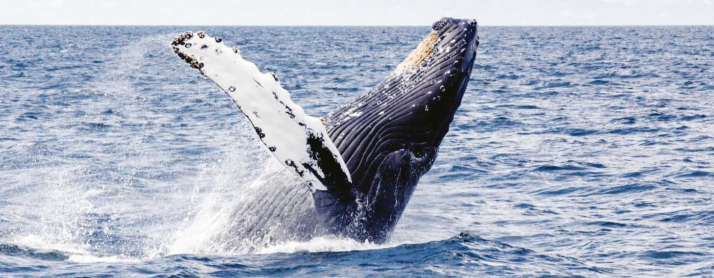
Whales roam throughout all of the world's oceans, communicating with complex and mysterious sounds. Their sheer size amazes us: the blue whale can reach lengths of more than 100 feet and weigh up to 200 tons—as much as 33 elephants.
Despite living in the water, whales breathe air. And like humans, they are warm-blooded mammals who nurse their young. A thick layer of fat called blubber insulates them from cold ocean waters.
Some whales are known as baleen whales, including blue, right, bowhead, sei, and gray whales. This refers to the fact that they have special bristle-like structures in their mouths (called baleen) that strain food from the water. Other whales, such as beluga or sperm whales, have teeth.
Whales are at the top of the food chain and have an important role in the overall health of the marine environment. Whales play a significant role in capturing carbon from the atmosphere; each great whale sequesters an estimated 33 tons of CO2 on average, thus playing their part in the fight against climate change.
Unfortunately, their large size and mythical aura does not protect them; six out of the 13 great whale species are classified as endangered or vulnerable, even after decades of protection. An estimated minimum of 300,000 whales and dolphins are killed each year as a result of fisheries bycatch, while others succumb to a myriad of threats including shipping and habitat loss.
Despite a moratorium on commercial whaling and a ban on international trade of whale products, three countries—Iceland, Japan, and Norway—continue their commercial whale hunts. Over 1,000 whales a year are killed for such commercial purposes. The blue whale, the largest animal ever known to have existed, was almost exterminated in the 20th century due to commercial whaling.
The United States and other International Whaling Commission (IWC) member countries have tried for years to persuade Iceland, Japan, and Norway to end their whaling as it undermines the effectiveness of the commission's commercial whaling ban. However, in 2019, Japan chose to walk away from the IWC and now conducts commercial whaling in its own territorial waters, outside of any international controls.
CLIMATE CHANGE
Warming oceans and loss of sea ice in the Arctic and Antarctic can affect the habitats and food of whales. Large patches of tiny plants and animals that they feed on will likely move or change in abundance as climate change alters seawater temperature, winds, and ocean currents. These changes can mean whales such as humpbacks and blues may have to migrate much further to reach feeding grounds, leaving them with less time to forage for food. The shift in food availability due to climate fluctuations has already hurt the reproductive rates of the endangered North Atlantic right whale.
NON Whale Affiliated

WHEN WILL DILLMAN’S phone started ringing shortly before lunch on August 14, he thought nothing of it. But the news was big. Fifty miles from the biologist’s office in South Carolina’s Department of Natural Resources, state law enforcement officers had happened upon Nathan Horton, a notorious turtle trapper and trafficker, hiding out in a storage shed. Nearby, they found more than 200 live turtles.
Earlier that morning the officers had gone out to Chester County to question Terry Dewayne Lucas, an associate of Horton’s, about illegal shipments of eastern box turtles sent outside the state. But when they arrived at Lucas’s house, they discovered a boat from Louisiana parked in the yard—filled with turtle traps.
“We knew from past investigation case work that Mr. Horton had some dealings/operated in Louisiana,” wrote Robert McCullough, a spokesman for the law enforcement team at the Department of Natural Resources, in Columbia, in an email. “He was last seen/known to be using a boat from Louisiana.” During questioning, the Lucas family revealed that Horton was in the shed.
The officer who’d called Dillman urged him to come out quickly to identify the turtles and care for them. It was a sweltering day, and the reptiles were clearly dehydrated and malnourished.
This was Dillman’s fourth or fifth such call since he’d started working at the natural resources department in 2013. “Thankfully, these are rare,” he says. “When you find one of these cases, it makes you wonder: How much more is out there that we’re not catching?”
Possibly a lot. It’s hard to pin down the scale of the pet trade in wild-caught U.S. turtles, experts say, but U.S. law enforcement probes have turned up an increasing number of big turtle trafficking cases in recent years. In each, the poachers and sellers have been responsible for helping transfer large numbers of turtles across states borders and on to Asia. Ryan Bessey, a U.S. Fish and Wildlife Service special agent who’s been focusing on the exotic turtle trade, says demand for these animals in Asia “has skyrocketed in the last five to ten years.” According to Bessey, North American species, including diamondback terrapins, box turtles, spotted turtles, and wood turtles seem to be particularly popular in the Asian exotic pet trade.Court documents suggest that Horton’s operation alone may have helped smuggle hundreds—if not thousands—of American turtles to China. According to surveillance footage and records obtained by law enforcement, the turtles were shipped from Atlanta to Los Angeles and onward to Guangzhou, in southern China. (It’s legal in the U.S. to trap and sell some turtle species domestically or export them abroad with proper paperwork, but state laws typically cap the trapping numbers. South Carolina doesn’t allow commercial-scale trapping at all.)
More recently, on October 18, the Florida Fish and Wildlife Conservation Commission announced that during a six-month period, two alleged poachers had illegally taken more than 4,000 turtles from the state’s waters. One of the suspects had been selling his catch to a buyer with links to Asian markets, according to the commission. The men’s catch included Florida box turtles, eastern box turtles, and several other species. (It’s illegal in Florida to sell wild turtles.)
“Wild turtle populations cannot sustain the level of harvest that took place here,” said Brooke Talley, the reptile and amphibian conservation coordinator for the commission, in a statement. “This will likely have consequences for the entire ecosystem.”
Back in South Carolina, when Dillman arrived at Lucas’s property, he found 216 eastern box turtles. A few had already succumbed to the harsh conditions. To revive the rest, Dillman soaked them in water and gave them snacks such as strawberries, tomatoes, and mushrooms. Despite that, he says, five more died.
Revered reptiles
“Much of Asia has always revered turtles for longevity and traditional Chinese medicine,” says Eric Goode, founder of the Turtle Conservancy. Now, with newfound wealth in the region, he says, turtles are just another rare, coveted item to collect, like wine, fine art, and cars. Demand has already wiped out large numbers of native turtles in Asia, making American turtles even more attractive, experts say. (Learn more about turtle trafficking in Southeast Asia.)
Court documents, interviews with turtle experts, and studies point to China and Hong Kong as primary destinations for trafficked American turtles. Still, other Asian nations—Thailand, Malaysia, Japan, Indonesia—are also popular markets for pet turtles. “The Asian turtle market is taking turtles out of Africa, Mexico, South America”—not just the U.S., adds Goode, who does surveys of turtles for sale at markets in Indonesia, Thailand, China, and Japan.
A 2018 analysis of the global conservation status of turtles and tortoises puts the problem in East Asia in stark terms: “An unsustainable turtle trade has gradually spread and expanded, first regionally and then globally, as wild turtle populations have been sequentially exploited, with many rendered commercially and ecologically extinct.” The Chinese three-striped box turtle, for example, is almost extinct in the wild, a victim of its popularity in the pet trade and for meat and traditional medicine. The Chinese box turtle, sometimes called the yellow-margined box turtle, is endangered for the same reasons. Willem Roosenburg, a turtle expert at Ohio University in Athens and the president of the Herpetologists League, says diamondback terrapins—caught in the past for meat consumption in soup—are now also being trapped and sent to Hong Kong and China for the exotic pet industry. Beyond poaching, turtles face other serious threats in the U.S., including mortality in crab pots, habitat loss, and predation by racoon and foxes.
Turtle poaching is particularly worrying to the Fish and Wildlife Service and conservation biologists. That’s because adult turtles are targeted—hatchlings are harder to find, says Kurt Buhlmann, a senior research associate at the University of Georgia’s Savannah River Ecology Laboratory. And, he says, as few as 10 to 25 percent of hatchlings may survive their first year in the wild. Because popularly targeted adult species can take five years or more to reach reproductive age, drawing down adult populations for the pet market could cause a species to collapse quickly—perhaps even before biologists and law enforcement become fully aware of the problem, Dillman says. “It could represent local extirpations for these species.” Buhlmann is now caring for the eastern box turtles seized from Nathan Horton and hopes to find out more about where they came from and whether they’re disease-free—prerequisites for possible reintroduction into the wild.
Playing catch-up
U.S. law enforcement agencies have been trying to coordinate across state lines to reduce illicit turtle sales. But, as Bessey says, because it’s a black market trade, it’s difficult, if not impossible, to know its total scale: “We are not seeing the total number of turtles being trafficked.” Moreover, the lack of federal and state enforcement officers relative to the vast areas and myriad water bodies available to poachers makes the prospect of shutting down illicit sales seem a distant prospect.
Global turtle demand has even made conservationists cautious about discussing locations of turtle populations at academic conferences or in published papers. (Poachers have been known to mine the academic literature for clues about potential targets.) Jacqueline Litzgus, a biology professor at Laurentian University, in Ontario, Canada, says she won’t even discuss vague geographic details at meetings.
At one of her Ontario study sites for wood turtles in the mid-1990s, she says, some “70 percent” of the turtles disappeared in just one or two years after a student did a thesis paper on them, which the poachers may have been able to obtain. No one ever found any turtle carcasses, Litzgus says, so she and her colleagues surmised that poaching—not disease—was to blame.
When turtle traffickers are caught, they’re typically charged with conspiracy to smuggle wildlife or with contravention of the Lacey Act, a federal statute that prohibits capture or sale of any species taken in violation of U.S., Native American, or foreign laws. Violations of the Lacey Act can lead to fines of up to $20,000, imprisonment of up to five years, or both.
Recent turtle busts have resulted in notable prison sentences—a rarity for wildlife crimes. In 2016, Kai Xu was sentenced to 57 months in prison by the U.S. District Court for the Eastern District of Michigan after he pleaded guilty to smuggling protected turtle species from the U.S. to China. Steven Baker, who led a syndicate trafficking various protected species between the U.S. and China, was apprehended in South Carolina in 2018 and sentenced in March 2019 to 27 months in prison.
Beginning in 2015, Ryan Bessey led an investigation into another prolific turtle trafficker, retired journalist David Sommers, who, over many years, trapped thousands of diamondback terrapins in New Jersey for sale to buyers engaged in smuggling the animals to Asia. When law enforcement officers arrested him, in July 2018, he told them that he’d sold roughly a thousand diamondback terrapins a year to buyers in the U.S. and Canada, netting him between $50,000 and $75,000. His clients included people known to ship the turtles to Asia, Bessey says.
Two months ago Sommers pleaded guilty to violating the Lacey Act when he falsely labeled packages containing the protected animals. He was sentenced in the U.S. District Court for the Eastern District of Pennsylvania to six months imprisonment and a fine of $250,000 in restitution to the state of New Jersey.
When the officers searched his house, in 2018, they recovered more than 3,000 diamondback terrapin hatchlings and almost two dozen box turtles, according to court records. They also found oxytocin, a drug used to induce labor in humans—and known to cause female turtles to release their eggs.
“He would take the turtles back to his home in Pennsylvania, and rather than let them naturally progress to a point where they were able to lay or drop their eggs, he would inject them with oxytocin,” Bessey says. “Once they then laid their eggs, he would sell off the adult females—a red flag because a legitimate breeder wouldn’t sell off his breeding stock.”
Sommers admitted to law enforcement that in addition to illegally collecting terrapin eggs and female turtles from New Jersey’s shores for “five to 15 years” (as stated in his plea agreement) and selling off the females days after they laid their eggs, he falsely claimed to be a turtle breeder, allowing him to appear legitimate and sell the poached turtles as “captive-bred.”
As court documents note, what he really did was pluck turtles from the wild, sell off their eggs, and then ship the remaining turtles to clients via the U.S. postal service or FedEx in socks or pouches, after first taping their legs to restrict their movement.
Repeat offender
Nathan Horton’s illegal turtle trapping activities first came to the attention of law enforcement in 2016 in Georgia. Federal court documents state that he was apprehended trapping turtles on Lake Jackson, a reservoir 45 miles southeast of Atlanta. Horton admitted that he was a commercial turtle collector and had a thousand active turtle traps on the lake. He said the turtles were shipped to a Californian buyer who then exported them to China. He was given a fine of $300 for using illegal traps.
But that didn’t deter Horton. A year later, he bought 46 turtles from undercover officers in Georgia. (The turtles had been implanted with transponders to help track them.) According to law enforcement, Horton told the undercover officers not to worry that the catch was illegal—if they were found out, he assured, the fines would be no worse than a “speeding ticket.”
About a week later, on August 20, 2017, Horton dropped off hundreds of turtles—including some bought from the undercover agents—for a flight to Los Angeles. Accompanied by fraudulent paperwork, they were then flown to Guangzhou, China. The illegal shipments were documented in surveillance footage and records, but court documents make no mention of any action against Horton for this incident.
Then, on August 21, Georgia law enforcement officers did cite Horton—this time for illegally placing traps on Lake Blackshear, about 150 miles south of Atlanta. The penalties: fines of about $4,350. It’s unclear whether Horton has paid that sum, and the U.S. Attorney’s Office for the Northern District of Georgia, which is handling his overall prosecution, declined to comment on these violations or provide further details about his case. After that 2017 incident, law enforcement lost track of him, according to McCullough, the South Carolina Department of Natural Resources spokesman.
That is until his arrest in South Carolina this August. Once again, Horton admitted to crimes related to turtles. According to the official law enforcement report, he said he’d been selling more than 20 eastern box turtles a year. It’s a misdemeanor in South Carolina to remove more than 10 eastern box turtles at a time, or more than 20 in a year, and the penalty is a fine of up to $200, up Horton’s arrest warrant, however, didn’t mention the misdemeanor. Instead it cited more serious charges, including that allegedly he violated the Lacey Act and engaged in interstate transport and sale of stolen property. His full charges and court date have not yet been set, and his court-appointed lawyer did not respond to a request for comment.
Fish and Wildlife’s Bessey says there’s a fine line between spurring interest in turtles and making sure that the enthusiasm doesn’t encourage people to take them from the wild. “There are threats around every corner for turtles,” he says.
“Even posting a photograph of one of these turtles, if taken with an iPhone, is a problem because it has an embedded latitude and longitude,” Ohio University’s Roosenburg says.
“Let turtles be,” Bessey adds. “Don’t grab a turtle you see crossing the road and take him home—just put him on the other side of the road in the direction he was going.”to 30 days in jail, or both.
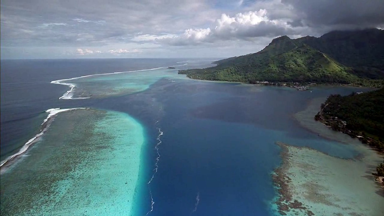
Protokollierung 04.11.2021 /Cyprus Geoecology & Drone Technology Sites / Ocean Waves from the shore just coast is shaking in heaven just Reiki
Cyprus / Geoecology / Portrayal Drone Technologically Use & Aerial Shot just Aeronautically View on Cyprus Countryside & Civilization just Geoecology from Republic of Cyprus / Reiki Music
Cyprus Drone Flight: The Republic of Cyprus occupies the southern part of the island of Cyprus in the eastern Mediterranean. The island (and capital city Nicosia) is divided with Turkey to the north. Known for beaches, it also has a rugged interior with wine regions. Coastal Paphos is famed for its archaeological sites relating to the cult of Aphrodite, including ruins of palaces, tombs and mosaic-tiled villas. Southern coastal city Limassol is the site of medieval Limassol Castle and an Old Port. Cypriots have been cultivating wine since the Bronze Age, and many wineries are based in and around Limassol.
Some vineyards occupy the southern slopes of the Troodos Mountains, home to pine-cedar forests, painted Byzantine churches and ski resorts. The western Akamas Peninsula National Park is a rugged area for hiking and mountain biking, with beaches accessible by off-road vehicles. There are more accessible beaches in places like Ayia Napa and Protaras in the east. [Source: wikipedia // Google]
Among others, you will see following places by Drone (Keywords): Cyprus, Republic of Cyprus, Mediterranean, Island, Nicosia, Capital, City, Wutrkey, Greece, Beaches, Paphos, Archeological, Aphrodite, Palace, Tomb, Limassol, Castle, Old, Port, Cypriots, Wine, Bronze, Age, Vineyard, Troodos, Waterfall, Mountain, Akamas, Peninsula, National, Park
Cyprus is a beautifully country which is offering a lot of pristine Sites in it's own element. Below is a video & representation of a drone technologically appliances which is filming the whole mountains & lanes just passing water enviromental area of it's pristine sides- This country has a lot to offer. Short video of 5 Min is eventually by the world wished water color very attractive for tourism & leading splendid water isles just archipelago. This land & state has even more to offer. This unique greenery from the countryside is very impressive & formidable as well as full of spots & firs in some segment as well as sequels.
This resort states in this country is highly welcomed worldwide on high scale & structured meted. The Republic of Cyprus is also water adjacent. Like you see the waves coming from the ocean against and you can hear Cyprus angels knocking on heavens door.
Seychelles / Resort State Video Presentation Beach & Tourism State / Posh Highly Comfortable Resort Terrain in African Continent / Great Acoustics / Protokoll 24.12.2021
Seychelles (/seɪˈʃɛlz/ , officially the Republic of Seychelles (French: République des Seychelles; Creole: La Repiblik Sesel), is an archipelagic island country consisting of 115 islands in the Indian Ocean at the eastern edge of the Somali Sea. Its capital and largest city, Victoria, is 1,500 kilometres (932 mi) east of mainland Africa. Nearby island countries and territories include the Comoros, Madagascar, Mauritius, and the French overseas regions of Mayotte and Réunion to the south; and Maldives and the Chagos Archipelago (administered by the United Kingdom as the British Indian Ocean Territory) to the east. It is the least populous sovereign African country, with an estimated 2020 population of 98,462.
Seychelles was uninhabited prior to being encountered by Europeans in the 16th century. It faced competing French and British interests until coming under full British control in the late 18th century. Since proclaiming independence from the United Kingdom in 1976, it has developed from a largely agricultural society to a market-based diversified economy, characterized by rapidly rising service, public sector, and tourism activities. From 1976 to 2015, nominal GDP grew nearly 700%, and purchasing power parity nearly 1600%. Since the late 2010s, the government has taken steps to encourage foreign investment. Today, Seychelles boasts the highest nominal per capita GDP of any African nation. It has the second-highest Human Development Index of any African country after Mauritius. It is one of only two African countries classified as a high-income economy by the World Bank (the other being Mauritius). Seychellois culture and society is an eclectic mix of French, British, and African influences, with more recent infusions of Chinese and Indian elements. The country is a member of the United Nations, the African Union, the Southern African Development Community, and the Commonwealth of Nations. Seychelles was uninhabited throughout most of recorded history. Some scholars assume that Austronesian seafarers and later Maldivian and Arab traders were the first to visit the archipelago. This assumption is based on the discovery of tombs, visible until 1910. The earliest recorded sighting by Europeans took place on 15 March 1503, recorded by Thomé Lopes aboard Rui Mendes de Brito, part of the 4th Portuguese India Armada commanded by Portuguese Admiral Vasco da Gama. Da Gama's ships passed close to an elevated island, probably Silhouette Island and the following day Desroches Island. The earliest recorded landing was in January 1609, by the crew of the Ascension under Captain Alexander Sharpeigh during the fourth voyage of the British East India Company. A transit point for trade between Africa and Asia, it was said that the islands were occasionally used by pirates until the French began to take control 1756 when a Stone of Possession was laid on Mahé by Captain Nicholas Morphey. The islands were named after Jean Moreau de Séchelles, Louis XV's Minister of Finance. The British frigate Orpheus commanded by Captain Henry Newcome arrived at Mahé on 16 May 1794, during the War of the First Coalition. Terms of capitulation were drawn up and the next day Seychelles was surrendered to Britain. Jean Baptiste Quéau de Quincy, the French administrator of Seychelles during the years of war with the United Kingdom, declined to resist when armed enemy warships arrived. Instead, he successfully negotiated the status of capitulation to Britain which gave the settlers a privileged position of neutrality. Seychellois stamps with portrait of Queen Elizabeth II.Britain eventually assumed full control upon the surrender of Mauritius in 1810, formalised in 1814 at the Treaty of Paris. Seychelles became a crown colony separate from Mauritius in 1903. Elections were held in 1966 and 1970.

The Seychelles president, who is head of state and head of government, is elected by popular vote for a five year term of office. The cabinet is presided over and appointed by the president, subject to the approval of a majority of the legislature.
The unicameral Seychellois parliament, the National Assembly or Assemblée Nationale, consists of 35 members, 26 of whom are elected directly by popular vote, while the remaining nine seats are appointed proportionally according to the percentage of votes received by each party. All members serve five-year terms. The Supreme Court of Seychelles, created in 1903, is the highest trial court in Seychelles and the first court of appeal from all the lower courts and tribunals. The highest court of law in Seychelles is the Seychelles Court of Appeal, which is the court of final appeal in the country. Then-President James Michel in his office in Victoria, 2009.Seychelles' long-term president France Albert René came to power after his supporters overthrew the first president James Mancham on 5 June 1977 in a coup d'état and installed him as president. René was at that time the prime minister. René ruled as a strongman under a socialist one-party system until 1993, when he was forced to introduce a multi-party system. He stepped down in 2004 in favour of his vice-president, James Michel, who was reelected in 2006, 2011 and again in 2015.On 28 September 2016, the Office of the President announced that Michel would step down effective 16 October, and that Vice President Danny Faure would complete the rest of Michel's term.On 26 October 2020, Wavel Ramkalawan, a 59-year old Anglican priest was elected the fifth President of the Republic of Seychelles. Ramkalawan was an opposition MP from 1993 to 2011, and from 2016 to 2020. He served as the Leader of the Opposition from 1998 to 2011 and from 2016 to 2020. Ramkalawan defeated incumbent Danny Faure by 54.9% to 43.5%. This marked the first time the opposition had won a presidential election. The primary political parties are the former ruling socialist People's Party (PP), known until 2009 as the Seychelles People's Progressive Front (SPPF) now called United Seychelles (US), and the socially liberal Seychelles National Party (SNP).
The election of the National Assembly was held on 22–24 October 2020. The Seychelles National Party, the Seychelles Party for Social Justice and Democracy and the Seychelles United Party formed a coalition, Linyon Demokratik Seselwa (LDS). LDS won 25 seats and US got 10 seats of the 35 seats of the National Assembly.
Further information: Foreign relations of Seychelles. Seychelles is a member of the United Nations, the African Union, the Indian Ocean Commission, La Francophonie, the Southern African Development Community and the Commonwealth of Nations.
From 1979 to 1981, the United States and South Africa were involved in the failed 1981 coup attempt. Under the Obama administration, the US began running drone operations out of Seychelles. In the Spring of 2013, members of the Special-Purpose Marine Air-Ground Task Force Africa mentored troops in Seychelles, along with a variety of other African nations.The Military of Seychelles is the Seychelles People's Defence Force which consists of a number of distinct branches: an Infantry Unit and Coast Guard, Air Force and a Presidential Protection Unit. India has played and continues to play a key role developing the military of Seychelles. After handing over two SDB Mk5 patrol vessels built by GRSE, the INS Tarasa and INS Tarmugli, to the Seychelles Coast Guard, which were subsequently renamed PS Constant and PS Topaz, India also gifted a Dornier 228 aircraft built by Hindustan Aeronautics Limited. India also signed a pact to develop Assumption Island, one of the 115 islands that make up the country. Spread over 11 km2 (4 sq mi), it is strategically located in the Indian Ocean, north of Madagascar. The island is being leased for the development of strategic assets by India.In 2018, Seychelles signed the UN treaty on the Prohibition of Nuclear Weapons.Further information: List of countries by incarceration rate
In 2014, Seychelles had the highest incarceration rate in the world of 799 prisoners per 100,000 population, exceeding the United States' rate by 15%. However, the country's actual population is less than 100,000; as of September 2014, Seychelles had 735 actual prisoners, 6% of whom were female, incarcerated in three prisons. Seychelles is a key participant in the fight against Indian Ocean piracy primarily committed by Somali pirates. Former president James Michel said that piracy costs between $7 million – $12 million a year to the international community: "The pirates cost 4% of the Seychelles GDP, including direct and indirect costs for the loss of boats, fishing, and tourism, and the indirect investment for the maritime security." These are factors affecting local fishing – one of the country's main national resources – which had a 46% loss in 2008–2009. International contributions of patrol boats, planes or drones have been provided to help Seychelles combat sea piracy.
Independence
In 1976, Seychelles was granted independence from the United Kingdom and became a republic. It has been a member of Commonwealth ever since. In the 1970s Seychelles was "the place to be seen, a playground for film stars and the international jet set". In 1977, a coup d'état by France Albert René ousted the first president of the republic, James Mancham. René discouraged overdependence on tourism and declared that he wanted "to keep the Seychelles for the Seychellois". The 1979 constitution declared a socialist one-party state, which lasted until 1991.In the 1980s there were a series of coup attempts against President René, some of which were supported by South Africa. In 1981, Mike Hoare led a team of 43 South African mercenaries masquerading as holidaying rugby players in the 1981 Seychelles coup d'état attempt. There was a gun battle at the airport, and most of the mercenaries later escaped in a hijacked Air India plane. The leader of this hijacking was German mercenary D. Clodo, a former member of the Rhodesian SAS. Clodo later stood trial in South Africa (where he was acquitted) as well as in his home country Germany for air piracy. In 1986, an attempted coup led by the Seychelles Minister of Defence, Ogilvy Berlouis, caused President René to request assistance from India. In Operation Flowers are Blooming, the Indian naval vessel Vindhyagiri arrived in Port Victoria to help avert the coup.
The first draft of a new constitution failed to receive the requisite 60% of voters in 1992, but an amended version was approved in 1993.
In January 2013, Seychelles declared a state of emergency; the tropical cyclone Felleng caused torrential rain, and flooding and landslides destroyed hundreds of houses.
Following the violent coup in 1977, the president always represented the same political party until the October 2020 Seychellois general election, which was historic in that the opposition party won. Wavel Ramkalawan was the first president who did not represent United Seychelles (the current name of the former Seychelles People's Progressive Front).
Planet Earth / Animals / Nature / ( Grandeur ) Biosphere / Geoecology / Texts ( Source Wikipedia ) Protokoll 01.08.2022
Nature, in the broadest sense, is the physical world or universe. "Nature" can refer to the phenomena of the physical world, and also to life in general. The study of nature is a large, if not the only, part of science. Although humans are part of nature, human activity is often understood as a separate category from other natural phenomena.[1]
The word nature is borrowed from the Old French nature and is derived from the Latin word natura, or "essential qualities, innate disposition", and in ancient times, literally meant "birth".[2] In ancient philosophy, natura is mostly used as the Latin translation of the Greek word physis (φύσις), which originally related to the intrinsic characteristics of plants, animals, and other features of the world to develop of their own accord.[3][4] The concept of nature as a whole, the physical universe, is one of several expansions of the original notion;[1] it began with certain core applications of the word φύσις by pre-Socratic philosophers (though this word had a dynamic dimension then, especially for Heraclitus), and has steadily gained currency ever since.
During the advent of modern scientific method in the last several centuries, nature became the passive reality, organized and moved by divine laws.[5][6] With the Industrial revolution, nature increasingly became seen as the part of reality deprived from intentional intervention: it was hence considered as sacred by some traditions (Rousseau, American transcendentalism) or a mere decorum for divine providence or human history (Hegel, Marx). However, a vitalist vision of nature, closer to the presocratic one, got reborn at the same time, especially after Charles Darwin.[1]
Within the various uses of the word today, "nature" often refers to geology and wildlife. Nature can refer to the general realm of living plants and animals, and in some cases to the processes associated with inanimate objects—the way that particular types of things exist and change of their own accord, such as the weather and geology of the Earth. It is often taken to mean the "natural environment" or wilderness—wild animals, rocks, forest, and in general those things that have not been substantially altered by human intervention, or which persist despite human intervention. For example, manufactured objects and human interaction generally are not considered part of nature, unless qualified as, for example, "human nature" or "the whole of nature". This more traditional concept of natural things that can still be found today implies a distinction between the natural and the artificial, with the artificial being understood as that which has been brought into being by a human consciousness or a human mind. Depending on the particular context, the term "natural" might also be distinguished from the unnatural or the supernatural.
Earth is the only planet known to support life, and its natural features are the subject of many fields of scientific research. Within the Solar System, it is third closest to the Sun; it is the largest terrestrial planet and the fifth largest overall. Its most prominent climatic features are its two large polar regions, two relatively narrow temperate zones, and a wide equatorial tropical to subtropical region.[7] Precipitation varies widely with location, from several metres of water per year to less than a millimetre. 71 percent of the Earth's surface is covered by salt-water oceans. The remainder consists of continents and islands, with most of the inhabited land in the Northern Hemisphere.
Earth has evolved through geological and biological processes that have left traces of the original conditions. The outer surface is divided into several gradually migrating tectonic plates. The interior remains active, with a thick layer of plastic mantle and an iron-filled core that generates a magnetic field. This iron core is composed of a solid inner phase, and a fluid outer phase. Convective motion in the core generates electric currents through dynamo action, and these, in turn, generate the geomagnetic field.
The atmospheric conditions have been significantly altered from the original conditions by the presence of life-forms,[8] which create an ecological balance that stabilizes the surface conditions. Despite the wide regional variations in climate by latitude and other geographic factors, the long-term average global climate is quite stable during interglacial periods,[9] and variations of a degree or two of average global temperature have historically had major effects on the ecological balance, and on the actual geography of the Earth
Geology
Geology is the science and study of the solid and liquid matter that constitutes the Earth. The field of geology encompasses the study of the composition, structure, physical properties, dynamics, and history of Earth materials, and the processes by which they are formed, moved, and changed. The field is a major academic discipline, and is also important for mineral and hydrocarbon extraction, knowledge about and mitigation of natural hazards, some Geotechnical engineering fields, and understanding past climates and environments.
Geological evolution
The geology of an area evolves through time as rock units are deposited and inserted and deformational processes change their shapes and locations.
Rock units are first emplaced either by deposition onto the surface or intrude into the overlying rock. Deposition can occur when sediments settle onto the surface of the Earth and later lithify into sedimentary rock, or when as volcanic material such as volcanic ash or lava flows, blanket the surface. Igneous intrusions such as batholiths, laccoliths, dikes, and sills, push upwards into the overlying rock, and crystallize as they intrude.
After the initial sequence of rocks has been deposited, the rock units can be deformed and/or metamorphosed. Deformation typically occurs as a result of horizontal shortening, horizontal extension, or side-to-side (strike-slip) motion. These structural regimes broadly relate to convergent boundaries, divergent boundaries, and transform boundaries, respectively, between tectonic plates.
An animation showing the movement of the continents from the separation of Pangaea until the present day
Earth is estimated to have formed 4.54 billion years ago from the solar nebula, along with the Sun and other planets.[12] The Moon formed roughly 20 million years later. Initially molten, the outer layer of the Earth cooled, resulting in the solid crust. Outgassing and volcanic activity produced the primordial atmosphere. Condensing water vapor, most or all of which came from ice delivered by comets, produced the oceans and other water sources.[13] The highly energetic chemistry is believed to have produced a self-replicating molecule around 4 billion years ago.[14]
Plankton inhabit oceans, seas and lakes, and have existed in various forms for at least 2 billion years[15]
Continents formed, then broke up and reformed as the surface of Earth reshaped over hundreds of millions of years, occasionally combining to make a supercontinent. Roughly 750 million years ago, the earliest known supercontinent Rodinia, began to break apart. The continents later recombined to form Pannotia which broke apart about 540 million years ago, then finally Pangaea, which broke apart about 180 million years ago.[16]
During the Neoproterozoic era, freezing temperatures covered much of the Earth in glaciers and ice sheets. This hypothesis has been termed the "Snowball Earth", and it is of particular interest as it precedes the Cambrian explosion in which multicellular life forms began to proliferate about 530–540 million years ago.
Since the Cambrian explosion there have been five distinctly identifiable mass extinctions.[18] The last mass extinction occurred some 66 million years ago, when a meteorite collision probably triggered the extinction of the non-avian dinosaurs and other large reptiles, but spared small animals such as mammals. Over the past 66 million years, mammalian life diversified.[19]
Several million years ago, a species of small African ape gained the ability to stand upright.[15] The subsequent advent of human life, and the development of agriculture and further civilization allowed humans to affect the Earth more rapidly than any previous life form, affecting both the nature and quantity of other organisms as well as global climate. By comparison, the Great Oxygenation Event, produced by the proliferation of algae during the Siderian period, required about 300 million years to culminate.
The present era is classified as part of a mass extinction event, the Holocene extinction event, the fastest ever to have occurred.[20][21] Some, such as E. O. Wilson of Harvard University, predict that human destruction of the biosphere could cause the extinction of one-half of all species in the next 100 years.[22] The extent of the current extinction event is still being researched, debated and calculated by biologists.
Costa Rica / Central America / Flora & Fauna / Environment Green / Beautifully Breathtaking Moments / Protokollierung 07.03.2022
Wildlife of Costa Rica
From Wikipedia, the free encyclopedia ( Resource)
The scarlet macaw is native to Costa Rica.
The Wildlife of Costa Rica comprises all naturally occurring animals, fungi and plants that reside in this Central American country. Costa Rica supports an enormous variety of wildlife, due in large part to its geographic position between the North and South American continents, its neotropical climate, and its wide variety of habitats. Costa Rica is home to more than 500,000 species, which represents nearly 5% of the total species estimated worldwide, making Costa Rica one of the 20 countries with the highest biodiversity in the world. Of these 500,000 species, a little more than 300,000 are insects.[1]
One of the principal sources of Costa Rica's biodiversity is that the country, together with the land now considered Panama, formed a bridge connecting the North and South American continents approximately three to five million years ago. This bridge allowed the very different flora and fauna of thBiodiversity
Costa Rica is considered to possess the highest density of biodiversity of any country worldwide.[3] While encompassing just one thirtieth of a percent of Earth's landmass, Costa Rica contains four percent of species estimated to exist on the planet.[4] Hundreds of these species are endemic to Costa Rica, meaning they exist nowhere else on earth. These endemic species include frogs, snakes, lizards, finches, hummingbirds, gophers, mice, cichlids, and gobies among many more.[5]
Costa Rica has 3 UNESCO World Heritage sites that are all natural assets and are as follows:
The Talamanca Mountain Range – La Amistad Reserves / International Friendship Park (declared in 1983)
The Isla del Coco National Park (declared in 1997)
The Guanacaste Conservation Area (declared in 1999). [6]
Epiphytes near Santa Elena
Costa Rica's biodiversity can be attributed to the variety of ecosystems within the country. Tropical rainforests, deciduous forests, Atlantic and Pacific coastline, cloud forests, and mangrove forests are all represented throughout the 19,730 square miles of Costa Rica's landmass.[7] The ecological regions are twelve climatic zones. This variation provides numerous niches which are filled by a diversity of species.
Benefits for humanity
Costa Rica demonstrates biodiversity conservation for developing countries. Over twenty-seven percent of the country's land has a protected status as national parks, wildlife refuges, forest preserves, and more.[8] The Costa Rican government is active in protecting its biodiversity for the ecological services they provide. The government imposes a five percent tax on gasoline to generate revenue to pay landowners to refrain from clear-cutting on their land and instead to create tree plantations. This provides Costa Ricans, or “Ticos” as they call themselves, incentive to become active tree farmers instead of cattle ranchers.[9] Tree farms provide some habitat for wildlife, enabling some measure of biodiversity to remain in these areas despite humans’ use of these natural resources.
Costa Rica's biodiversity contributes to the numerous ecological services the environment provides. Every aspect of the ecosystem from the different species of plants to the diversity of animal species contributes to natural services like water purification, provision of food, fuel, fiber, and biochemicals, nutrient cycling, pollination and seed dispersal, and climate regulation, just to name a few.[10] As the diversity of species increases, more of these services can be provided and to a greater extent.
Biodiversity has contributed to the economy of Costa Rica. Ecotourism brings in 1.92 billion dollars in revenue for the country.[11] Ecotourism is defined as "tourism directed toward exotic, often threatened, natural environments, especially to support conservation efforts and observe wildlife." Costa Rica's abundant biodiversity makes the country an attractive destination for ecotourism. Thirty-nine percent of tourists cite nature as their primary reason for visiting the country.[12] The profitable industry of ecotourism entices businesses to capitalize on natural resources by protecting and preserving them rather than consuming them.
Threats to biodiversity
Threats to Costa Rica's biodiversity include a rapidly growing human population, developing coastlines for the industry of tourism and harmful agricultural practices all contributing to pollution and environmental degradation. The practice causing the largest concern for Costa Rica's environment is deforestation. Costa Rica has the fourth highest rate of deforestation in the world. Almost four percent of its current forested lands are cut each year. Clearing land for cattle ranching is the most common cause of deforestation. This form of environmental damage along with the farming of monocultures leads to areas where only a few species of plants are present. Ultimately, decreases in plant diversity leads to decreased animal diversity.[13]
Insects
Butterflies and moths
The zebra longwing butterfly.
The Heliconius doris butterfly.
There are about 1,251 species of butterflies and at least 8,000 species of moths. Butterflies and moths are common year round but are more present during the rainy season. Ten percent of known butterfly species worldwide reside in Costa Rica.[14]
Costa Rican butterflies and moths have made amazing adaptations to the environment. Some examples of these are the following:
Swallowtail caterpillars imitate bird droppings and many others have bright colours to warn predators of bodily toxins.
What someone could easily mistake for a butterfly, a wasp, or a leaf in Costa Rica might be a moth engaging in Müllerian or Batesian mimicry.
Ecotourism is one of Costa Rica's primary economic resources, and the country's butterflies add a lot to that. They bring life to tropical forests, not only with the diversity in colour, but with the magnificence of the flowers that they help pollinate.
Some common butterflies and moths in Costa Rica include:
Thoas swallowtail
Marpesia berania
Doxocopa laure
Banded peacock
Zebra longwing
Morpho butterfly
Green page moth
Glasswing
Some notable insects in Costa Rica are stingless bees and sweat bees such as L. figueresi and L. aeneiventre, ants such as leaf-cutter ants and army ants, Hercules beetle, and many katydids.
Other invertebrates
Invertebrate species make up most of Costa Rica's wildlife. Of the estimated 500,000 species, about 493,000 are invertebrates (including spiders and crabs). It is known that there are tens of thousands of insects and microscopic invertebrates in every land type and elevation level. However, they are largely unnoticed or unidentified.
Main article: List of non-marine molluscs of Costa Rica
There are known 183[15] species and subspecies of terrestrial gastropods from Costa Rica and numerous freshwater gastropods and bivalves.
Amphibians
A red-eyed tree frog (Agalychnis callidryas).
Costa Rica is home to around 175 amphibians, 85% of which are frogs. Frogs in Costa Rica have interesting ways of finding fishless water to raise their young in. Fish, of course, will eat tadpoles and eggs. Poison dart frogs put their eggs in water pools in bromeliads. Other methods include searching ponds before laying eggs, and laying eggs in wet soil. There are 35 species of Elutherodoctylus frogs, 26 species of Hyla frogs and 13 species of glassfrogs.
Notable frog species in Costa Rica include red-eyed tree frog, a few species of poison dart frogs, the semitransparent glassfrogs, and the large smoky jungle frog. Some other notable toad species in Costa Rica include the ten species of Bufo toads and the giant toad, a huge toad known for its wide appetite. It has been documented eating almost anything, including vegetables, ants, spiders, any toad smaller than itself, mice, and other small mammals.
Besides the frog species, approximately 40 species of lungless salamander and two species of caecilian are found in the country, both rarely seen and little known. Costa Rican amphibians range in size from the rainforest rocket frog, at 1.5 cm (0.5 in), to the giant toad, at up to 15 cm (6 in) and 2 kg (4.4 lb).
Representatives of all three orders of amphibians - caecilians, salamanders, and frogs and toads - reside in Costa Rica. Due to environmental degradation and the sensitive nature of amphibians to pollution, Costa Rica has seen declines and even extinctions in amphibian populations. Monteverde Cloud Forest Reserve is a critical habitat for certain species of the order Anura. However, forty percent of the members of this order that reside in this reserve are estimated to have gone extinct since 1987. This equals twenty species of frogs and toads.[16]
The golden toad, an amphibian once endemic to Costa Rica, is now extinct.
The highland-dwelling golden toad, Bufo periglenes, has not been witnessed in its highly restricted habitat of the central mountain ranges of Costa Rica since 1989. Within one year, the number of juveniles counted at their most prevalent breeding site declined from over 1,500 individuals to only one. The International Union for the Conservation of Nature (IUCN) declared the golden toad endangered, but it is likely extinct due to the lack of sightings since over two decades ago. Suspected causes for the toads probable extinction include a combination of intense El Nino weather patterns which resulted in a drought, increased pollution added to the environment, climate change, and an invasive fungal species, Chiriqui harlequin.[16]
Amphibians in Costa Rica have acquired many adaptations for survival. Some frog species, especially those of the poison dart frogs, have learned to lay eggs in water devoid of predatory fish. For some species this means laying eggs in small collections of water in the leaf litter, then transporting the eggs to bromeliads. Other species have adapted the ability of direct development. This means that the frog develops completely inside the egg without transitioning to the tadpole phase. This decreases vulnerable exposure to predators and the frog emerges from its egg as a froglet, much better equipped to protect itself.[17]
Reptiles
Eyelash viper (Bothriechis schlegelii)
Approximately 225 types of reptiles are found in Costa Rica. This includes over 70 species of lizards, mostly small, forest-dwelling anoles. Large lizards such as the striped basilisk, black iguana, and green iguana are probably the country's most regularly encountered reptiles. Snakes number about 120 species in the country, including 5 powerful boas and a wide diversity of harmless colubrids.
There are about 20 venomous snakes, including colorful coral snakes and various vipers such as the common eyelash viper and two formidable, large bushmasters. The venomous snakes of Costa Rica are often observed without issue if given a respectful distance.
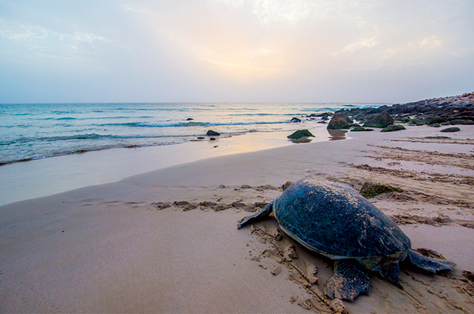
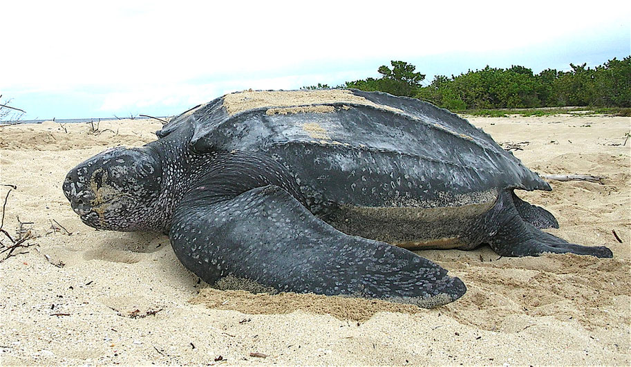
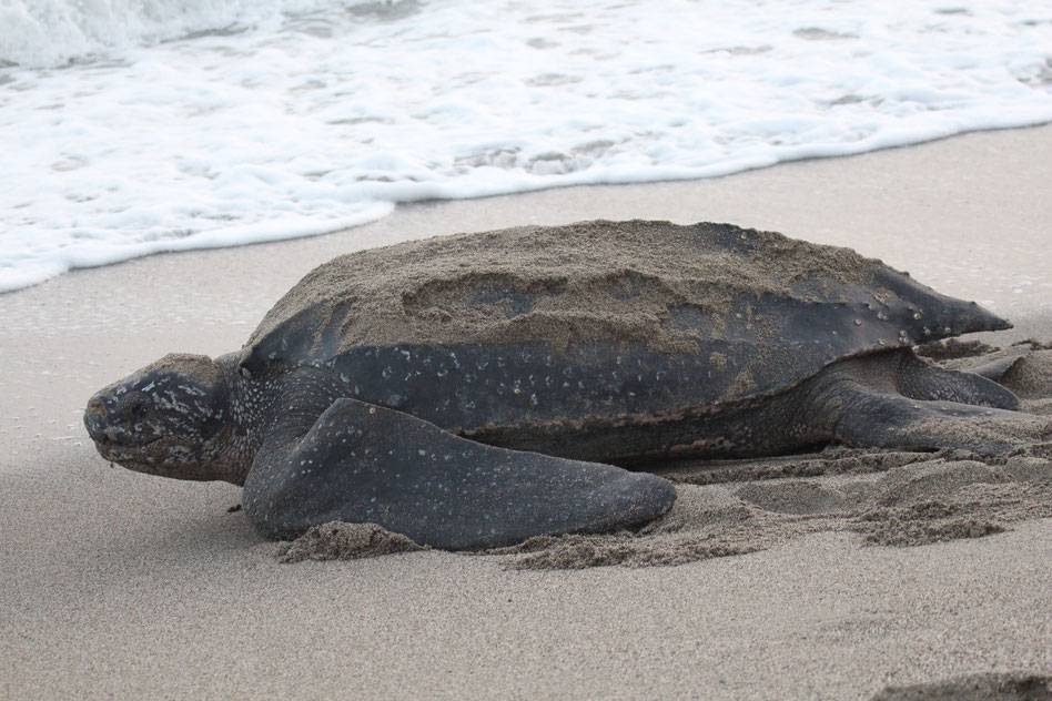
Among turtles, 5 of the world's 7 species of sea turtles nest on the nation's beaches. Two crocodilians, the widespread spectacled caiman and the large, sometimes dangerous American crocodile are found in Costa Rica. The country's reptiles range in size from the delicate 15 cm (6 in) Hallowell's centipede snake of the genus Tantilla to the hulking leatherback turtle, at 500 kg (1100 lb) and 150 cm (60 in).
Mammals
Costa Rica is home to nearly 250 species of mammal. Medium-sized forest-dwelling mammals are often the most appreciated mammalian fauna of the country. These include four species of monkeys such as the frantic white-headed capuchin and noisy mantled howlers; two species of sloths; the opportunistic white-nosed coati; and the fierce predator, the tayra.
Bats comprise more than half of the mammal species in the country, unusually outnumbering rodents twice over. Bats are adapted to various foraging methods and foods; including nectar, fish, insects and parasitized blood, as the case with the infamous vampire bats. Prominent bats include the tiny, communal roosting Honduran white bat and the huge, predatory spectral bat, the largest New World bat. Large fauna, such as tapir, jaguar, and deer are rarely encountered, being both elusive and tied to now-fragmented undisturbed habitats. Costa Rican mammals range in size from the 3-gram thumbless bat of the family Furipteridae to the 250 kg (550 lb) Baird's tapir.
Anteaters are common in lowland and middle elevation throughout Costa Rica. The most commonly seen of Costa Rica's three anteaters species is the northern tamandua. The giant anteater is huge and endangered. The other anteater is the silky anteater.
Wild cats
Wild cats that exist in Costa Rica are: jaguars, ocelots, pumas, jaguarundi, margays, and little spotted cats.
Most big cats in Costa Rica are nocturnal or hide in trees in the rainforest like the margay. The most likely place to find a big cat is in the Simon Bolivar Zoo in San José, Costa Rica where there is a selection of all the native big cats along with other animals. Ocelots usually hunt on the ground at night and rarely climb trees. An ocelot's diet consists of birds, monkeys, rats, and other small animals. The little spotted cat is the smallest wild cat and does not grow bigger than a house cat. They live in cloud forests up to 3200 m.
The jaguar is the largest wild cat in Costa Rica and can grow up to 2 m. They are very rare in Costa Rica and their numbers continue to decline drastically. The jaguarundi looks like a cross between a weasel and a cat. It is plain grey with a sleek body, hunts day and night, and has adapted best to human changes. The margay spends most of its life in trees. The puma is the second largest cat in Central America and its fur is brown and unspotted.
Birds
894 bird species have been recorded in Costa Rica (including Cocos Island), more than all of the United States and Canada combined. More than 600 of the Costa Rican species are permanent residents, and upwards of 200 are migrants, spending portions of the year outside of the country, usually in North America. Seven of the Costa Rican species are considered endemic, and 19 are globally threatened. Costa Rica's birds range in size from the scintillant hummingbird, at 2.2 grams and 6 cm (2.4 in), to the huge jabiru, at 6.5 kg (14.3 lb) and 150 cm (60 in) (the American white pelican is heavier, but is an accidental species).
Scarlet macaws are a common species of Costa Rica. Unlike many bird species, macaws form a monogamous breeding pair and mate for life. Both males and females help care for young and raise chicks for up to two years before they fledge. Threats to the macaw include their popularity in the pet trade. One individual can be sold for up to one thousand dollars.[18]
The resplendent quetzal, a trogon with a stunning physical appearance, can also be found in parts of Costa Rica. The bird's long grey and black tail feathers can stretch up to a meter long and are its defining feature. Resplendent quetzals live in cloud forests and are most active in the canopy. They can be found in several of Costa Rica's parks and reserves, including the Monteverde Cloud Forest, Santa Elena Cloud Forest Reserve, Braulio Carrillo National Park, Poas Volcano National Park, Chirripo National Park, and the Juan Castro Blanco National Park. Resplendent quetzals eat fruit, insects, small frogs, lizards, and snails and have distinctive echoing calls. Unfortunately, the bird is endangered because its cloud forest habitat has been widely destroyed across Central America.[19]
The mangrove hummingbird is endemic to Costa Rica and specializes in feeding from the tea mangrove plant with its uniquely shaped beak.
Hummingbird species demonstrate adaptation with bill shape and size. Certain species have specialized bills that allow them to feed from the flowers of certain species of plants. The relationship between the hummingbird and plant is mutualistic because the hummingbird transfers pollen between plant individuals in exchange for nectar. Because different species of hummingbirds are adapted to specific plants, [pollination] of the right plants with the right pollen is ensured.[18] The mangrove hummingbird is endemic to Costa Rica and specializes in feeding from the tea mangrove plant.[5][20]
Costa Rican officials have explored the possibility of shutting down their national zoos in an effort to demonstrate a more advanced appreciation for the wildlife in their country.
Costa Rica / Central America / Rainforest/ Flora & Fauna / Tropically ( Geoecology )
https://www.andreaspennophotography.de
Take a Look and get excited / Take a Watch on the beautifully charismatically animals and get fascinated / Epic Resolution & Compression
Costa Rica / Environment / Central America / Worthwhile to study all this video
Tourism in World named Hawaii / Short Related Expressive Journey through Hawaii Tourism / ( Resource Wikipedia ) / Protokollierung 22.02.2023
The Hawaiian Islands
Hawaii is a U.S. state that is an archipelago in the Pacific Ocean. Of the eight major islands, Hawaii, Oʻahu, Maui, and Kauaʻi have major tourism industries, while it is limited on Molokai and Lānaʻi and access to Niihau and Kahoʻolawe is restricted. The state's favorable climate, tropical landscape, beaches, and culture make it among the U.S's most visited states. In 2017 alone, according to state government data, there were over 9.4 million visitors to the Hawaiian Islands with expenditures of over $16 billion.[1] Tourism makes up 21% of the state's economy, with many of Hawaii's largest industries revolving around the constant flow of tourists.[2] Due to the mild year-round weather, tourist travel is popular throughout the year. The summer months and major holidays are the most popular times for outsiders to visit, however, especially when residents of the rest of the United States are looking to escape from cold winter weather. The Japanese, with their economic and historical ties to Hawaii and the US as well as relative geographical proximity, make up the largest group of inbound international travelers to the islands, reaching 1,568,609 in 2017.[3] The average Japanese stays only 5 days while other Asians stay over 9.5 days and spend 25% more.
Hawaii was first populated no later than the 2nd century CE by people of Polynesian origin, most likely from Tahiti.[4] Subsequent Western contact began as a consequence of European Enlightenment exploration and was continued by Protestant ministers of New England origin in the early 19th century.
16th century
According to Hawaiian tradition, a vessel wrecked at Keʻei near Kealakekua Bay in the 1560s with only two survivors: the captain and his sister. Their penitent posture led to the naming of the place as Kūlou; they later intermarried with the native population and their descendants became prominent chiefs. The timing coincides with the voyage of a small fleet of three vessels commanded by Álvaro de Saavedra Cerón, who departed Mexico on October 31, 1569; during that voyage, two ships disappeared after a storm.[5][6]: 103
Spaniard Juan Gaetano, who had served as the pilot of a 1522 expedition led by Ruy López de Villalobos, reportedly discovered the Hawaiian Islands during that voyage. The official narrative of the voyage reported that a group of islands were found after approximately 30 days of sailing west from Mexico, which were named the Islas del Rey; these were later speculated to be the Caroline Islands or Marshall Islands, not Hawaii. The coordinates of Gaetano's discovery were not reported outside the Spanish Empire until 1743, when a manuscript chart was captured from the annual treasure galleon by HMS Centurion, commanded by Captain George Anson; although the latitude was approximately correct and the physical features were similar to the Hawaiian Islands, the longitude was 17° east of the actual position of Hawaii. The Spanish Hydrographical Department reported in 1865 that an ancient manuscript chart confirmed Gaetano's discovery from 1555, which he had named Islas de Mesa.[5][6]: 98–99 continues as to whether the Spanish visited the islands before James Cook.
18th century
In 1748, Anson published a redrawn version of the captured chart in A Voyage Round the World,[7] one of the best-selling books of its day.[8] Anson's chart showed the Pacific to be relatively barren, but the three voyages of James Cook would add significant detail.[9]
The first recorded western visitor to Hawaii was Captain James Cook on his third and final fatal voyage in the Pacific. Cook's ships first sighted Niihau and Kauai on January 19, 1778, and anchored near Waimea the following evening. As described by James Jackson Jarves in 1843, during the first visit "the natives manifested the greatest respect and kindness toward their visitors, and both parties indulged in a lucrative trade, yet [the natives'] propensity for thieving was continually manifested ... Theft or lying were to them no crimes. Success in either was a virtue, and it was not until several severe lessons, in regard to the enormity of the former had been received, that their discretion got the better of temptation." He went on to add "the commander manifested a laudable humanity, in endeavoring to shield the population from the evil effects which so inevitably result from connection between foreign seamen and the native females. But his efforts were vain. If the discipline of his own crew could have been strictly enforced, the eagerness of the women was not to be repressed."[6]
Cook's fleet departed on February 2, returning to Hawaii in November, when they began resupplying their ships and mapping the coastline. They anchored in Kealakekua Bay in January 1779, and stayed for 19 days; although they departed on February 6, they were forced to return for repairs on February 11. A series of misunderstandings would lead Cook to attempt to kidnap the aliʻi nui of the island of Hawaii, Kalaniʻōpuʻu, resulting in Cook's death.
19th century
Prominent 19th-century travelers to Hawaii included journalist Isabella Bird,[10] along with a number of American and British authors. Tourist visits remained around 2,000 per year from 1872 to 1898.[11] American writers include Mark Twain aboard the Ajax as a travel journalist with the Sacramento Daily Union in 1866,[12][13] and Herman Melville, who deserted from his whaler in 1843 and later found passage back to the mainland that summer aboard USS United States.[14][15] Twain's unfinished novel of Hawaii was incorporated into his A Connecticut Yankee in King Arthur's Court, with King Arthur bearing striking similarities to Kamehameha V, the first reigning monarch Twain was to meet. The "modernizing" potential offered by the Connecticut Yankee from the future is a satire of the potentially negative Protestant Missionary influence on Hawaiian life. Melville's writing of the Pacific includes Typee and Omoo (considered factual travel accounts when published) and his Pacific experiences would develop into the portrayal of Queequeg in Moby-Dick.
British writers include the Scot Robert Louis Stevenson, whose subsequent In the South Seas was published based on his voyages.[16] During his stay in the islands, he wrote a stunning defense of Father Damien's work with the lepers of Kalaupapa against the politicized views of Father Damien's Protestant detractors. Consequently, Hawaiʻi is home to the eponymous Stevenson Middle School. Stevenson later died in Samoa.[17]
Regular commercial passenger, cargo, and mail service to Hawaii via steamship started in 1870 with the North Pacific Transportation Company of Australia. The Oceanic Steamship Company was incorporated by John D. Spreckels, son of sugar baron Claus Spreckels, on December 24, 1881 to establish a steamship line between San Francisco and Hawaii.[18] Oceanic signed a contract in July 1882 with William Cramp & Sons for two "first-class iron steamships" intended for the Honolulu route;[19] these were completed in 1883 as the Alameda and Mariposa.[20] Spreckels traveled to the East Coast intending to contract for the building of two more steamships, but returned in March 1886 after having purchased Zealandia and Australia from John Elder & Company.[21]
William Matson had served as captain of Claus Spreckels's yacht (named Lurline) and in turn, Spreckels helped Matson purchase his first ship, the Emma Claudina (named for Spreckels's daughter), which made its first voyage to Hawaii in 1882.[22] Matson would go on to found the Matson Navigation Company, whose genesis was in the first Lurline, purchased to replace the smaller Emma Claudina; that first Lurline was sold to Matson by Spreckels and undertook a two-month maiden sail from San Francisco to Hawaii in 1887, marking the start of Matson's commercial passenger service to the Hawaiian Islands.[23]
19th-century development in Hawaii played a big part in the increase of tourism that continued into the 21st century. In 1888, a writer for the Los Angeles Herald extolled "culture, refinement, and a hospitality so cordial that one scarcely meets it elsewhere" joined with "the island air that is kept pure and sweet by the gentle trade winds' refreshing currents".[24] Advanced technologies including cars, marketing, hotels, and shopping malls allow vacationers to visit a modernized tropical island, which contributes heavily to steady growth in tourism. Conversely, the Native Hawaiian population continues to decrease, resulting in a loss of authentic Hawaiian culture on the islands, similar to other Oceanian islands.[25]
20th century
In 1907, Jack London and his wife Charmian sailed to Hawaii, learning the "royal sport" of surfing and travelling by horseback to Haleakala and Hana, as chronicled in his book The Cruise of the Snark. 1929 saw 22,000 tourists visit Hawaii, while the number of tourists exceeded 1 million for the first time in 1967.[26]
Marine service
The second SS Lurline, completed in 1908, was the first steamship built for Matson; she was designed to accommodate passengers (51) in addition to cargo.[22][27][28] Matson added Wilhelmina, which made her maiden voyage from San Francisco to Honolulu in February 1910.[29] Both of these ships were named after the daughters of prominent executives: Lurline Matson, daughter of founder William Matson; and Wilhelmina Tenney, daughter of Edward Davies Tenney, the chairman of Castle & Cooke, the Honolulu agent for Matson.[22]
By 1913, Matson was building more passenger liners for the Honolulu run, Manoa and Matsonia.[30][31] Direct service from Hawaii to Los Angeles was established by Manoa in October 1914.[32] Another Matson steamship, Maui, sister to Matsonia,[22] was launched in 1916 at San Francisco, the largest passenger ship then constructed on the West Coast.[33] However, Matson's Hawaiian routes were interrupted by World War I, as the government announced plans to requisition five ships in 1917;[34] that was later reduced to three: Wilhelmina, Matsonia, and Maui,[35] which served as troop transports before they were released in 1919.[36] Maui made 13 roundtrips to France, carrying 37,344 troops; Matsonia,[37] 14 roundtrips (38,974); and Wilhelmina, 13 roundtrips (23,014).[22]
Growth in tourist travel followed World War I. Matson opened its eponymous headquarters on Market Street in 1924, and conducted marine operations via berths and warehouses at Piers 30–32 in San Francisco; Castle & Cooke also moved into new offices in Honolulu at approximately the same time, and Matson ships docked at Aloha Pier, surrounding Aloha Tower.[22] Matson acquired the Oceanic Steamship operation in May 1926, extending its reach past Hawaii to Australia and New Zealand,[38][39] and introduced the SS Malolo, the first of its four "White Fleet" ocean liners for Hawaii service, in 1927;[40] at the time, she was the largest passenger steamship built in the United States.[41][42] Malolo was one part of a three-pronged effort devised by William P. Roth, the son-in-law of Captain Matson and Matson's general manager, and E.D. Tenney, named president of Matson after Matson's death in 1917, to develop the modern Hawaiian tourist industry; a luxury hotel (completed in 1927 as the Royal Hawaiian, in partnership with the Territorial Hotel Company) and golf course (Waialae Country Club) would also help transform Hawaii into a premier resort destination.[11]: 119–121 However, Malolo had an inauspicious start to her career, colliding with the steamship Jacob Christensen in heavy fog during sea trials in May 1927;[43] despite the delay to inaugurating modern ocean liner service, annual tourist traffic to Hawaii jumped from 17,500 (1927) to 22,000 (1929) until the Great Depression started, cutting annual traffic to less than 11,000 tourists in 1932 and 1933.[11]: 120–121
Matson would go on to build three sister ships to Malolo, all completed in 1932: Mariposa, Monterey, and a third Lurline. After Lurline completed her complicated 30,000-mile (48,000 km) maiden voyage from New York around the Pacific Ocean in early 1933[23] Matson established regular Honolulu service with the four ships. Two-week voyages were operated by Malolo ("clockwise" on a Los Angeles—Hawaii—San Francisco route) and Lurline ("counter-clockwise" on a San Francisco—Hawaii—Los Angeles route); the subsidiary Matson-Oceanic lines operated Mariposa and Monterey on longer four-week cruises from San Francisco and Los Angeles to Australia and New Zealand via Hawaii.[44] Matson purchased the assets of the Territorial Hotel Company in 1932, giving cruise passengers disembarking in Honolulu a choice from three hotels: the Moana, the Alexander Young, or the Royal Hawaiian.[11]: 121 In 1934, a planned 88-day Pacific cruise aboard Malolo was canceled after heavy demand for passenger service to Hawaii tied up all of Matson's available ships;[45] by 1941, tourist traffic had rebounded past pre-Depression levels, with 31,000 tourists visiting Hawaii that year.[11]: 121
Lurline was steaming from Honolulu to San Francisco during the attack on Pearl Harbor; she proceeded at full speed and returned to San Francisco on December 10.[46] The United States's entry into World War II once again prompted the government to requisition Matson liners as troopships; all four "White Fleet" ships (Lurline, Mariposa, Matsonia [ex-Malolo],[37] and Monterey) served along with the older Maui.[47][48] Maui accommodated 1,650 passengers after refit;[47]: 45 Lurline, 4,037;[47]: 198 Matsonia (ex-Malolo), 2,976;[47]: 223 Mariposa, 4,272;[47]: 222 and Monterey was used to carry war brides and dependents.[47]: 361 In addition, Matson converted a number of cargo vessels to troopships and operated others.[47]
After the war, Matsonia (ex-Malolo) was the first to return to commercial service in May 1946,[49][50] but she was laid up and sold in 1948 following the completion of the US$18,000,000 (equivalent to $203,000,000 in 2021) rebuild of Lurline.[51][52][53] When Lurline arrived in Honolulu on April 21, 1948 after her maiden voyage following the rebuild, she was adorned with the longest lei ever made, 80 feet (24 m) long using 1 mile (1.6 km) of orange crêpe paper.[54]
A rebuild of Mariposa and Monterey was also announced; the rebuild would have given each ship the capacity for 726 passengers (488 first class and 238 cabin class), served by 437 crew.[55] However, the cost of the rebuild was higher than expected, and work was halted;[56][57] both ships remained in the reserve fleets at Alameda and Suisun.[58] Mariposa was sold in 1953[59] and Monterey was not repurchased by Matson until 1956;[60] later that year a new Mariposa (ex-Pine Tree Mariner) and Monterey (ex-Free State Mariner), both converted from cargo ships launched in 1952, entered service for Matson on their traditional California–Hawaii–Australia/New Zealand route.[61] After Monterey (1932) was rebuilt at Newport News, she was renamed Matsonia and alternated with Lurline on the Hawaii run starting from June 1957[62][63] until Lurline was sold in 1963. Matsonia (ex-Monterey) was renamed Lurline in December 1963 to carry on the name.[64] The advent of jetliner travel, cutting the five-day voyage from California to Hawaii down to a matter of hours and reducing the cost of travel, decimated cruise passenger traffic;[65] Matson exited the passenger business altogether in 1970 and sold its last White Fleet liner, Lurline (ex-Matsonia, ex-Monterey).[66][67][68]
Air service
The United States Navy used two PN-9 seaplanes to attempt the first nonstop flight to Hawaii from mainland America in 1925; the aircraft, designated PN-9 Nos. 1 and 3, departed San Francisco on August 31 for Kahului, Maui.[69][70] A third seaplane, the Boeing PB-1, was intended to join the other two,[71] but it was scrubbed at the last minute. No. 3 was forced down by engine trouble approximately 300 nautical miles (560 km; 350 mi) from San Francisco;[72] it capsized while being towed back to Mare Island Navy Yard for repairs.[73] A tailwind that was predicted to aid the airplanes 600 miles (970 km) into the 2,100-mile (3,400 km) flight never materialized, and strong headwinds increased fuel consumption. No. 1 ran out of fuel approximately 275 miles (443 km) short of Hawaii as it was entering a squall.[73][74][75] Commander John Rodgers had intended to land No. 1 at the USS Aroostook (a seaplane tender), one of the picket ships stationed along the flight path, to refuel and then continue the flight to Hawaii. However, the crew was unable to find Aroostook and landed after exhausting their fuel; they fashioned a fabric sail from the plane's lower wing and sailed towards Hawaii, averaging 50 miles (80 km) each day over the next nine days.[69] The search for PN-9 No. 1 was called off by September 8, and the Navy began to prepare the PB-1 to re-attempt the nonstop flight to Hawaii.[76] During its sail, the seaplane passed as close as 40 miles (64 km) from Oahu, then steered for Kauai, where they were finally spotted by the patrolling submarine USS R-9 10 miles (16 km) off Nāwiliwili Bay. The submarine towed the PN-9 to the harbor, where they were greeted by the native population, 218 hours after being forced down.[69]
Succeeding where the Navy had failed, on June 29, 1927, Lieutenants Lester Maitland and Albert Hegenberger of the United States Army Air Corps landed at Wheeler Field following the first successful non-stop flight to Hawaii, piloting the Fokker C-2 Bird of Paradise from Oakland to Honolulu.[77] Rumors of a Hawaiian flight attempt had followed the crew across the country as he piloted the Fokker to the West Coast in mid-June;[78][79] they denied the rumors, claiming it was a transcontinental test of the trimotor Fokker, as it was laden with the equivalent weight of 30 men.[80] Bird of Paradise was flown to San Francisco on June 25 from San Diego to make final preparations for the Hawaii attempt,[81] and the plane departed shortly after 7 AM on June 28 from Oakland Municipal Airport; a parallel competing attempt by a civilian pilot was scrubbed after the windshield was cracked.[82] Maitland and Hegenberger returned to San Francisco aboard the Matson steamer Maui;[83] Bird of Paradise remained in Hawaii to provide inter-island service.[84]
Inspired by Charles Lindbergh's successful transatlantic flight in April 1927, pineapple magnate James Dole announced the Dole Air Race in May 1927, which would award US$25,000 (equivalent to $390,000 in 2021) to the crew of the first airplane to complete a non-stop flight from Oakland, California to Honolulu, Hawaii, within a 12-month period starting in August 1927.[85] Eight aircraft eventually flew in the Dole Air Race; however, only two aircraft completed the flight and ten people were killed in the attempt.
The first commercial passenger aircraft service to the Hawaiian Islands from San Francisco commenced on October 21, 1936, with a once-weekly flight operated by Pan American Airways aboard the Martin M-130 Clipper; this first revenue service flight was taken by Hawaii Clipper.[86][87] Pan Am introduced the larger Boeing 314 to the route in 1939; onboard accommodations included a lounge and sleeping berths.[88]
In 1944, the Civil Aeronautics Board held hearings to break up the Pan Am monopoly on overseas flights from America[89][90] and after World War II, other airlines were granted routes to Hawaii; United Airlines and Northwest Airlines soon began service to Honolulu from major West Coast cities: San Francisco (United, 1947),[91] Los Angeles (United, 1950),[65] Seattle (Northwest, 1949), and Portland (Northwest, 1949).
21st century
Widespread fear of flying after the September 11 attacks greatly reduced tourism in Hawaii. The Washington Post wrote in March 2002 that "at the Polynesian Cultural Center ... the barefoot guides seemed to outnumber visitors".[92] Although 2006 and 2007 saw a big increase of tourism, it soon took a turn for the worse when Hawaii's economy plummeted, but later recovered. Tourism officials said several factors have kept sightseers away: Two major airlines and two cruise ships stopped operating in the Aloha State, reducing options for visitors, high fuel prices last summer deterred travel, then recessions in Japan and the U.S., as well as California's economic meltdown, slowed the flow of tourists.[93]
In 2007, Japanese tourists on average used to spend more money than American tourists; because of this, tourism-related businesses in Hawaii used to value Japanese customers. However this has all changed with the collapse of the value of the yen and the Japanese economy. The average Japanese tourist now stays only 5 days, while the average East Asian tourist from China or Korea stays more than 9.5 days and spends 25% more.[94][95]
Hawaii has been seeing increased numbers of visitors from South Korea and China.
In 2011, Hawaii saw increasing arrivals and share of foreign tourists from Canada, Australia and China increasing 13%, 24% and 21% respectively from 2010.[99][100] In 2014 a record 8.3 million visitors arrived to Hawaii (39.4% from the U.S. West, 20.8% from the U.S. East, 18.3% from Japan, 6.3% from Canada, 15.2% others), spending $14.7 billion.[101][102] The amount increased to 9.4 million visitors spending over $16 billion in 2017.
Hawaii / Tourism Sites / Clear Pristine Blue Water / Reiki / Take A Look /
To be in Research of Volcanoes and its Geoecology in World & Humankind Inclusive Video Resource / Natural Product of World / Protokoll 22.02.2023 AD
BY MAYA WEI-HAAS
PUBLISHED JANUARY 15, 2018
Volcanoes are Earth's geologic architects. They've created more than 80 percent of our planet's surface, laying the foundation that has allowed life to thrive. Their explosive force crafts mountains as well as craters. Lava rivers spread into bleak landscapes. But as time ticks by, the elements break down these volcanic rocks, liberating nutrients from their stony prisons and creating remarkably fertile soils that have allowed civilizations to flourish.
There are volcanoes on every continent, even Antarctica. Some 1,500 volcanoes are still considered potentially active around the world today; 161 of those—over 10 percent—sit within the boundaries of the United States.
But each volcano is different. Some burst to life in explosive eruptions, like the 1991 eruption of Mount Pinatubo, and others burp rivers of lava in what's known as an effusive eruption, like the 2018 activity of Hawaii's Kilauea volcano. These differences are all thanks to the chemistry driving the molten activity. Effusive eruptions are more common when the magma is less viscous, or runny, which allows gas to escape and the magma to flow down the volcano's slopes. Explosive eruptions, however, happen when viscous molten rock traps the gasses, building pressure until it violently breaks free.
How do volcanoes form?
The majority of volcanoes in the world form along the boundaries of Earth's tectonic plates—massive expanses of our planet's lithosphere that continually shift, bumping into one another. When tectonic plates collide, one often plunges deep below the other in what's known as a subduction zone.
As the descending landmass sinks deep into the Earth, temperatures and pressures climb, releasing water from the rocks. The water slightly reduces the melting point of the overlying rock, forming magma that can work its way to the surface—the spark of life to reawaken a slumbering volcano.
Not all volcanoes are related to subduction, however. Another way volcanoes can form is what's known as hotspot volcanism. In this situation, a zone of magmatic activity—or a hotspot—in the middle of a tectonic plate can push up through the crust to form a volcano. Although the hotspot itself is thought to be largely stationary, the tectonic plates continue their slow march, building a line of volcanoes or islands on the surface. This mechanism is thought to be behind the Hawaii volcanic chain.
Located in Hawai'i Volcanoes National Park, Kīlauea is one of the most active volcanoes in the world. Watch magma carve a path of destruction in Kīlauea’s otherworldly landscape in this mesmerizing short film by Tyler Hulett.
Where are all these volcanoes?
Some 75 percent of the world's active volcanoes are positioned around the ring of fire, a 25,000-mile long, horseshoe-shaped zone that stretches from the southern tip of South America across the West Coast of North America, through the Bering Sea to Japan, and on to New Zealand.
This region is where the edges of the Pacific and Nazca plates butt up against an array of other tectonic plates. Importantly, however, the volcanoes of the ring aren't geologically connected. In other words, a volcanic eruption in Indonesia is not related to one in Alaska, and it could not stir the infamous Yellowstone supervolcano.
What are some of the dangers from a volcano?
Volcanic eruptions pose many dangers aside from lava flows. It's important to heed local authorities' advice during active eruptions and evacuate regions when necessary.
One particular danger is pyroclastic flows, avalanches of hot rocks, ash, and toxic gas that race down slopes at speeds as high as 450 miles an hour. Such an event was responsible for wiping out the people of Pompeii and Herculaneum after Mount Vesuvius erupted in A.D. 79.
Similarly, volcanic mudflows called lahars can be very destructive. These fast-flowing waves of mud and debris can race down a volcano's flanks, burying entire towns.
Ash is another volcanic danger. Unlike the soft, fluffy bits of charred wood left after a campfire, volcanic ash is made of sharp fragments of rocks and volcanic glass each less than two millimeters across. The ash forms as the gasses within rising magma expand, shattering the cooling rocks as they burst from the volcano's mouth. It's not only dangerous to inhale, it's heavy and builds up quickly. Volcanic ash can collapse weak structures, cause power outages, and is a challenge to shovel away post-eruption.
Can we predict volcanic eruptions?
Volcanoes give some warning of pending eruption, making it vital for scientists to closely monitor any volcanoes near large population centers. Warning signs include small earthquakes, swelling or bulging of the volcano's sides, and increased emission of gasses from its vents. None of those signs necessarily mean an eruption is imminent, but they can help scientists evaluate the state of the volcano when magma is building.
However, it's impossible to say exactly when, or even if, any given volcano will erupt. Volcanoes don't run on a timetable like a train. This means it's impossible for one to be “overdue” for eruption—no matter what news headlines say.
What is the largest eruption in history?
The deadliest eruption in recorded history was the 1815 explosion of Mount Tabora in Indonesia. The blast was one of the most powerful ever documented and created a caldera—essentially a crater—4 miles across and more than 3,600 feet deep. A superheated plume of hot ash and gas shot 28 miles into the sky, producing numerous pyroclastic flows when it collapsed.
The eruption and its immediate dangers killed around 10,000 people. But that wasn't its only impact. The volcanic ash and gas injected into the atmosphere obscured the sun and increased the reflectivity of Earth, cooling its surface and causing what's known as the year without a summer. Starvation and disease during this time killed some 82,000 more people, and the gloomy conditions are often credited as the inspiration for gothic horror tales, such as Mary Shelley's Frankenstein.
Although there have been several big eruptions in recorded history, volcanic eruptions today are no more frequent than there were a decade or even a century ago. At least a dozen volcanoes erupt on any given day. As monitoring capacity for—and interest in—volcanic eruptions increases, coverage of the activity more frequently appears in the news and on social media. As Erik Klemetti, associate professor of geosciences at Denison University, writes in The Washington Post: “The world is not more volcanically active, we’re just more volcanically aware.”
Red Sea Global ( The Red Sea ) / Gigantically Prospering Luxury Regenerative Tourism Spot in the World / Saudi Arabia / Vision 2030 / 16.03.2023 AD
So The Red Sea is peculiar & especially unique in its design & manufacturing site on the red sea. HRH is a opportunistic & developed head of state of the circumstances of " The Red Sea ". It's a ( PIF ) Public Investment Fund Product from the red sea water region of the Kingdom of Saudi Arabia. PIF was once founded in the Kingdom in 1971. It's an investment catalytic arabian (PIF) job creating platform which supervises since 2015 over 100 PIF Investments. The Red Sea is part of Red Sea Global next to Amaala. So the Red Sea started construction since 2019-2023 till this moment came. This annual year 2023 this project will open doors charismatically & family friendly, peoples philanthropically for everybody coming to the Kingdom of Saudi Arabia in World and wants to be in one of the most luxurious & pleasant holiday spots worldwide. HRH Mohmamed Bin Salman welcomes everybody coming to the Kingdom in different Tourism Places of Red Sea or in the Mainland,namely the new Diriyah 5th Giga Project from ( PIF ) from Riyadh when it's accomplished or NEOM " Trojena" and different more Tourism Sites in the Kingdom. So The Red Sea is modern,qualified, luxurious,established,human friendly,cooperative,future of tourism worldwide.It's the futuristic exemplar for Tourism. Like NEOM " The Line " is the futuristic living of urbanized & metropolitian living. Also approximately 6 Billion of US Dollar will come to strenghten the GDP ( Gross Domestic Product ) from " The Red Sea "annually .Its area of project's size belongs to a chiffre of 28.000² km in the province Tabuk.Mohammed Bin Salman the prince from the Kingdom has hugh priorities in the ( PIF ) and its Projects also " Red Sea Global. His priorities is all about a hugh developed red sea creative & full-fledged and modernized established tourism place in world accomplished in 2030, also Amaala developed fully 2028, belonging to Red Sea Global. The Red Sea will create 70.000 Jobs in the Giga Project till 2030. It will supervise 22 Islands which are opportunistic & luxurious generative forthcoming 2030 fulfilled created from 90 Islands.2030 will be 8000 Hotels at availibility & 50 Resorts will be created. Also a coastline of 200km is present.75 % are standing and preserved natural conservation & protection from the Kingdom. 1000 Residential Houses will be 2030 accomplished.Also Red Sea Global won prizes & acclaimed and cheered from all over the world, especially Volcanic ( Volcanoes ) are presently from the Site. The Red Sea is emcompassed from Umluj & Al Wajh geographically. The Kingdom of Saudi Arabia one of the biggest countries of world will profit financially & economically from this Act.The Red Sea Global supervises over 800 Contracts since beginning. 15 Million Seeds & Plants just Flora is presently of this arabian tourism site. The vegetation is now in the Vision 2030 a product of the kingdom.The Red Sea will open first hotels & resorts in 2023 from Six Senses,St.Regis, Edition,Fairmont,Raffles,Rosewood,Intercontinental Hotels & Resorts, Grand Hyatt, Miraval, Jumeriah. So all the Hotels will be since 2023 first Hotels for the Red Sea Project. The Kingdom's Prince is very proud of his arabian folk & nation.Also for all agencies worldwide which in chiffre Thousands of Journalism & Agencies protocolating about the Kingdom of Saudi Arabia. Like i said Mohammed is a very great human figure in world history. So Mohammed Bin Salman is chairman of the PIF ( Public Investment Fund ) with headquarters in Riyadh. The Red Sea from ( Red Sea Global ) can be truly realistically now estimated about Visitors of 1 Million Human Civilization in the Kingdom in 2030. The Kingdom expects 100 Million Tourism raw in 2030 to visit the Empire & Kingdom from Mohammed Bin Salman. As far as the Volcanoes on the Coastline from 200km they will be dormant while you is lying on a wellness site and you can ovserve like in human nature presently the volanoes from your bungalow on the Red Sea. The Ecosystem from the Red Sea Project is very pristine and will be preserved under hugh protection's principles.Especially you can dive under water in special red sea regions with adjusted & aligned ecosystematic water temperatures on the Red Sea in the Kingdom.So Mohammed Bin Salman is reforming the Kingdom from Crude Oil Dependence into a Tourism Crude Oil Independence State of World. The Red Sea is wholly visionary & an example of pristine beauty of the Red Sea. Which is an Ocean of the World History.So The Red Sea from ( Red Sea Global ) is also in possession of a marina & has diving possibilities. So to experience this Red Sea Occasion is an adventure & spectacle never seen before in the whole wide world. Also ( Qiddiya ) which will also receiving 2023 first visitors is a one unique life's adventure for the whole family & people all over the world coming to the Kingdom of Saudi Arabia. So different Tourism Sites will be established next time in the Kingdom. Also Riyadh the capital has a lot of Tourism Potential in Kingdom. So ( Red Sea Global ) The Red Sea & Amaala are welcoming Millions of Guests & Visitors in 2030. So after 2030 the gates will be enormously & gigantically open in the Kingdom of Saudi Arabia.Because all the Projects will be finished & accomplished. Book Values will be written. The Saudi Arabian Riyal will be written & calculated for Mohammed Bin Salman & his Kingdom and his Red Sea. 2030 will be globally arabian gates open for different than expect & and clearly standing in expectations. The Kingdom will be very high intellectual & intelligent established with new investment & new economically ambitions & visions and new planning on worldwide status. So nowadays the Vision 2030 from the Arabian State is also productive,lucrative,economically solid & strong & under construction. So now Mohammed Bin Salman is blessed in Kingdom and leads his role & opportunity in complete engagement as a prime minister of his country. The Prince will create & reform the arabian kingdom in a great establishment & under hugh principles and attractive investment. The Reformation from Saudi Arabia is glorified & since 7 Years of Vision very successfully.Thank You Very Much. Mohammed Bin Salman from Saudi Arabia.
Yours Sincerely,
Andreas Penno
A.P.P
So Take A Look at ( Protokollierung )
Stay Actively on Industry


Kingdom of Thailand / Ocean / Asia Pacific / Tourism / Beach & Crystal Blue Water / Earthly Paradise / Protokoll 12.05.2023
Tourism is an economic contributor to the Kingdom of Thailand. Estimates of tourism revenue directly contributing to the GDP of 12 trillion baht range from one trillion baht (2013) 2.53 trillion baht (2016), the equivalent of 9% to 17.7% of GDP.[1][2] When including indirect travel and tourism receipts, the 2014 total is estimated to be the equivalent of 19.3% (2.3 trillion baht) of Thailand's GDP.[3]: 1 The actual contribution of tourism to GDP is lower than these percentages because GDP is measured in value added not revenue. The valued added of the Thailand's tourism industry is not known (value added is revenue less purchases of inputs). According to the secretary-general of the Office of the National Economic and Social Development Council in 2019, the government projects that the tourism sector will account for 30% of GDP by 2030, up from 20% in 2019.[4] Tourism worldwide in 2017 accounted for 10.4% of global GDP and 313 million jobs, or 9.9% of total employment.[5]: 1 Most governments view tourism as an easy moneymaker and a shortcut to economic development. Tourism success is measured by the number of visitors.[6] Prior to the pandemic, Thailand was world’s eighth most visited country as per World Tourism rankings compiled by the United Nations World Tourism Organization. In 2019, Thailand received 39.8 million international tourists, ahead of United Kingdom and Germany. [7] and received fourth highest international tourism earning at 60.5 billion US dollar. The Tourism Authority of Thailand (TAT), a state enterprise under the Ministry of Tourism and Sports, uses the slogan "Amazing Thailand" to promote Thailand internationally.[8] In 2015, this was supplemented by a "Discover Thainess" campaign.[9]
Among the reasons for the increase in tourism in the 1960s were the stable political atmosphere and the development of Bangkok as a crossroads of international air transport.[10] The hotel industry and retail industry both expanded rapidly due to tourist demand. It was boosted by the presence of US GIs who arrived in the 1960s for rest and recuperation (R&R) during the Vietnam War.[11] During this time, international tourism was becoming the new trend as living standards increased throughout the world and travel became faster and more dependable with the introduction of new technology in the air transport sector.[12] Tourist numbers have grown from 336,000 foreign visitors and 54,000 GIs on R&R in 1967[11] to 32.59 million foreign guests visiting Thailand in 2016.[13][14][15] The Tourism Authority of Thailand (TAT) claims that the tourist industry earned 2.52 trillion baht (US$71.4 billion) in 2016, up 11% from 2015.[13] TAT officials said their revenue estimates, for foreign and domestic tourists combined, show that tourism revenue for all of 2017 may surpass earlier forecasts of 2.77 trillion baht (US$78.5 billion).[13] In 2015, 6.7 million people arrived from ASEAN countries and the number is expected to grow to 8.3 million in 2016, generating 245 billion baht.[16] The largest numbers of Western tourists came from Russia (6.5%), the UK (3.7%), Australia (3.4%) and the US (3.1%).[17] Around 60% of Thailand's tourists are return visitors.[18] n 2014, 4.6 million Chinese visitors travelled to Thailand.[17][19] In 2015, Chinese tourists numbered 7.9 million or 27% of all international tourist arrivals, 29.8 million; 8.75 million Chinese tourists visited Thailand in 2016.[20][16] In 2017, 27% of the tourists that came to Thailand came from China.[21] Thailand relies heavily on Chinese tourists to meet its tourism revenue target of 2.2 trillion baht in 2015 and 2.3 trillion in 2016. However, in 2020, it was reported that Chinese tourists now ranked Thailand as third most popular foreign tourist destination, having been the top previously.[22] It is estimated that the average Chinese tourist remains in the country for one week and spends 30,000–40,000 baht (US$1,000–1,300) per person, per trip.[23] The average Chinese tourist spends 6,400 baht (US$180) per day—more than the average visitor's 5,690 baht (US$160).[16][19] According to Thailand's Tourism Authority, the number of Chinese tourists rose by 93% in the first quarter of 2013, an increase that was attributed to the popularity of the Chinese film Lost in Thailand that was filmed in the northern province of Chiang Mai. Chinese media outlets have claimed that Thailand superseded Hong Kong as the top destination for Chinese travellers during the 2013 May Day holiday.[24] In 2013, the Chinese National Tourism Administration published A Guide to Civilized Tourism which has specific statements regarding how to act as a tourist in Thailand.[25] In 2015, Thailand hosted 1.43 million Japanese travellers, up 4.1% from 2015, generating 61.4 billion baht, up 6.3%. In 2016, Thailand expects 1.7 million Japanese tourists, generating 66.2 billion baht in revenue.[26] TAT estimates that 1.9 million Indian tourists visited in 2019, up 22% from 2018, generating 84 billion baht in revenue, up 27%.[27] To accommodate foreign visitors, the Thai government established a separate tourism police force with offices in the major tourist areas and its own central emergency telephone number.[28] Since the opening of the Vietnam, Cambodia, and Laos borders in the late 1900s, competition has increased because Thailand no longer has the monopoly on tourism in Southeast Asia.[29] Destinations like Angkor Wat, Luang Prabang and Halong Bay now rival Thailand's former monopoly in the Indochina region. To counter this, Thailand is targeting niche markets such as golf holidays, holidays combined with medical treatment or visits to military installations.[20] Thailand has also plans to become the hub of Buddhist tourism in the region.[30]
International rankings
In 2008, Pattaya was 23rd with 4,406,300 visitors, Phuket 31st with 3,344,700 visitors, and Chiang Mai ranked 78th place with 1,604,600 visitors.[31] In a list released by Instagram that identified the ten most photographed locations worldwide in 2012, Suvarnabhumi Airport and Siam Paragon shopping mall were ranked number one and two respectively, more popular than New York City's Times Square or Paris's Eiffel Tower.[32] In 2013, Thailand was the 10th "top tourist destination" in the world tourism rankings with 26.5 million international arrivals.[33]: 6 In the MasterCard 2014 and 2015 Global Destination Cities Index, Bangkok ranked the second of the world's top-20 most-visited cities, trailing only London.[34][35] The U.S. News' 2017 Best Countries report ranked Thailand at 4th globally for adventure value and 7th for cultural heritage.The Travel and Tourism Competitiveness Report 2015 published by the World Economic Forum ranked Thailand 35 of 141 nations. Among the metrics used to arrive at the rankings, Thailand scored high on "Natural Resources" (16 of 141 nations) and "Tourist Service Infrastructure" (21 of 141), but low on "Environmental Sustainability" (116 of 141) and "Safety and Security" (132 of 141. In 2016, Bangkok ranked 1st surpassing London and New York in Euromonitor International's list of "Top City Destinations" with 21 million visitors. In 2019, Bangkok ranked 1st surpassing Paris and London in Mastercard's list of "Global Destination Cities Index 2019" with 22.78 million visitors. Phuket was 14th with 9.89 million visitors and Pattaya 15th with 9.44 million visitors.[39]
Tourism in Japan / 6800 Archipelago in Japan / Tourism Worldwide A.P.P / Nature / Environment / Flora & Fauna / Protokollierung 12.05.2023
As of 2019, Japan attracted 31.88 million international tourists.[1] Japan has 21 World Heritage Sites, including Himeji Castle, Historic Monuments of Ancient Kyoto and Nara. Popular foreigner attractions include Tokyo and Hiroshima, Mount Fuji, ski resorts such as Niseko in Hokkaido, Okinawa, riding the Shinkansen and taking advantage of Japan's hotel and hotspring network.
The 2017 Travel and Tourism Competitiveness Report ranked Japan 4th out of 141 countries overall, which was the highest in Asia. Japan gained relatively high scores in almost all of the featured aspects, such as health and hygiene, safety and security, cultural resources and business travel.[2]
History
Himeji Castle in Himeji (WHS)
The origins of early traditions of visits to picturesque sites are unclear, but an early sight-seeing excursion was Matsuo Bashō's 1689 trip to the then "far north" of Japan, which occurred not long after Hayashi Razan categorized the Three Views of Japan in 1643. During the Edo era of Japan, from around 1600 to the Meiji Restoration in 1867, travel was regulated within the country through the use of shukuba or post stations, towns where travelers had to present appropriate documentation. Despite these restrictions, porter stations and horse stables, as well as places for lodging and food were available on well-traveled routes. During this time, Japan was a closed country to foreigners, so no foreign tourism existed in Japan.
Following the Meiji Restoration and the building of a national railroad network, tourism became more of an affordable prospect for domestic citizens and visitors from foreign countries could enter Japan legally. As early as 1887, government officials recognized the need for an organized system of attracting foreign tourists; the Kihinkai (貴賓会), which aimed to coordinate the players in tourism, was established that year with Prime Minister Itō Hirobumi's blessing. Its early leaders included Shibusawa Eiichi and Ekida Takashi. Another major milestone in the development of the tourism industry in Japan was the 1907 passage of the Hotel Development Law, as a result of which the Railways Ministry began to construct publicly owned hotels throughout Japan.[3]
For much of post-World War II history, Japan has been an exceptionally unattractive tourist destination for its population and GDP size; from 1995 to 2014, it was by far the least visited country in the G7 despite being the second largest country in the group,[4] and as of 2013 was one of the least visited countries in the OECD on a per capita basis.[5]
Current status
Domestic tourism remains a vital part of the Japanese economy and Japanese culture. Children in many middle schools see the highlight of their years as a visit to Tokyo Disneyland or perhaps Tokyo Tower, and many high school students often visit Okinawa or Hokkaido. The extensive rail network together with domestic flights sometimes in planes with modifications to favor the relatively short distances involved in intra-Japan travel allows efficient and speedy transport. International tourism plays a smaller role in the Japanese economy compared to other developed countries; in 2013, international tourist receipts was 0.3% of Japan's GDP, while the corresponding figure was 1.3% for the United States and 2.3% for France.[7][8]
In inbound tourism, Japan was ranked 28th in the world in 2007 when the country had the 2nd largest GDP. In 2009, the Yomiuri Shimbun published a modern list of famous sights under the name Heisei Hyakkei (the Hundred Views of the Heisei period).
Tourists from South Korea have made up the largest number of inbound tourists several times in the past. In 2010, their 2.4 million arrivals made up 27% of the tourists visiting Japan.[9]Travelers from China have been the highest spenders in Japan by country, spending an estimated 196.4 billion yen (US$2.4 billion) in 2011, or almost a quarter of total expenditure by foreign visitors, according to data from the Japan Tourism Agency.[10]According to the Japan National Tourism Organization in 2017, 3 out of 4 foreign tourists came from other parts of East Asia, namely South Korea, Mainland China, Taiwan and Hong Kong.[11] Japanese video games, manga and anime play a role in driving tourism to Japan. In surveys held by Statista between 2019 and 2020, 24.2% of tourists from the United States, 7.7% of tourists from China and 6.1% of tourists from South Korea said they were motivated to visit Japan because of Japanese popular culture.[12] The Japanese government hoped to receive 40 million foreign tourists every year by 2020,[13] however, due to the COVID-19 pandemic, the country received only 4.12 million foreign tourists in 2020.[14] In September 2022, the Japanese government announced that visa requirements from some countries will be waived from October 2022, in a move to reopen travel after the COVID-19 pandemic border restrictions.[15][16] Prior to the pandemic, Japan did not require tourist visas for 68 countries and regions.
Following the triple meltdown of the nuclear reactors in Fukushima, caused by the earthquake and tsunami, the number of foreign visitors in Japan were declined for months. However, in September 2011, some 539,000 foreign people visited Japan, this was 25 percent down compared with the same month in 2010. This decline was largely attributed to the Fukushima nuclear accident and the stronger yen made a visit to Japan more expensive. To boost tourism the Japanese Tourism Agency announced in October 2011 a plan to give 10,000 round-trip air tickets to Japan to encourage visitors to come. In 2012, free tickets would be offered if the winners would write online about their experiences in Japan. They also would need to answer some questions about how they felt while visiting Japan after the triple disaster and how the interest in tourism in Japan could be renewed. About US$15 million would be spent on this program.[17][18] On December 26, 2011, The Japan Tourism Agency reported on their site that the "Fly to Japan! Project", which would have given out 10,000 round-trip tickets to Japan, was not approved by the government for fiscal year 2012.[19]
World Tourism / Sunset / Beach / 4k / Kagoshima, Japan / Protokollierung / Release Date / 12.05.2023 / Protokoll
Sunset
Sunset, also known as sundown, is the daily disappearance of the Sun below the horizon due to Earth's rotation. As viewed from everywhere on Earth (except the North and South poles), the equinox Sun sets due west at the moment of both the spring and autumn equinoxes. As viewed from the Northern Hemisphere, the Sun sets to the northwest (or not at all) in the spring and summer, and to the southwest in the autumn and winter; these seasons are reversed for the Southern Hemisphere. The time of sunset is defined in astronomy as the moment when the upper limb of the Sun disappears below the horizon.[1] Near the horizon, atmospheric refraction causes sunlight rays to be distorted to such an extent that geometrically the solar disk is already about one diameter below the horizon when a sunset is observed. Sunset is distinct from twilight, which is divided into three stages. The first one is civil twilight, which begins once the Sun has disappeared below the horizon, and continues until it descends to 6 degrees below the horizon. The second phase is nautical twilight, between 6 and 12 degrees below the horizon. The third phase is astronomical twilight, which is the period when the Sun is between 12 and 18 degrees below the horizon.[2] Dusk is at the very end of astronomical twilight, and is the darkest moment of twilight just before night.[3] Finally, night occurs when the Sun reaches 18 degrees below the horizon and no longer illuminates the sky. Locations further north than the Arctic Circle and further south than the Antarctic Circle experience no full sunset or sunrise on at least one day of the year, when the polar day or the polar night persists continuously for 24 hours.
Stages of the twilight period
The time of sunset varies throughout the year, and is determined by the viewer's position on Earth, specified by latitude and longitude, altitude, and time zone. Small daily changes and noticeable semi-annual changes in the timing of sunsets are driven by the axial tilt of Earth, daily rotation of the Earth, the planet's movement in its annual elliptical orbit around the Sun, and the Earth and Moon's paired revolutions around each other. During winter and spring, the days get longer and sunsets occur later every day until the day of the latest sunset, which occurs after the summer solstice. In the Northern Hemisphere, the latest sunset occurs late in June or in early July, but not on the Summer solstice of June 21. This date depends on the viewer's latitude (connected with the Earth's slower movement around the aphelion around July 4). Likewise, the earliest sunset does not occur on the winter solstice, but rather about two weeks earlier, again depending on the viewer's latitude. In the Northern Hemisphere, it occurs in early December or late November (influenced by the Earth's faster movement near its perihelion, which occurs around January 3).[citation needed] Likewise, the same phenomenon exists in the Southern Hemisphere, but with the respective dates reversed, with the earliest sunsets occurring some time before June 21 in winter, and latest sunsets occurring some time after December 21 in summer, again depending on one's southern latitude. For a few weeks surrounding both solstices, both sunrise and sunset get slightly later each day. Even on the equator, sunrise and sunset shift several minutes back and forth through the year, along with solar noon. These effects are plotted by an analemma.[5][6] Neglecting atmospheric refraction and the Sun's non-zero size, whenever and wherever sunset occurs, it is always in the northwest quadrant from the March equinox to the September equinox, and in the southwest quadrant from the September equinox to the March equinox. Sunsets occur almost exactly due west on the equinoxes for all viewers on Earth. Exact calculations of the azimuths of sunset on other dates are complex, but they can be estimated with reasonable accuracy by using the analemma.[citation needed] As sunrise and sunset are calculated from the leading and trailing edges of the Sun, respectively, and not the center, the duration of a daytime is slightly longer than nighttime (by about 10 minutes, as seen from temperate latitudes). Further, because the light from the Sun is refracted as it passes through the Earth's atmosphere, the Sun is still visible after it is geometrically below the horizon. Refraction also affects the apparent shape of the Sun when it is very close to the horizon. It makes things appear higher in the sky than they really are. Light from the bottom edge of the Sun's disk is refracted more than light from the top, since refraction increases as the angle of elevation decreases. This raises the apparent position of the bottom edge more than the top, reducing the apparent height of the solar disk. Its width is unaltered, so the disk appears wider than it is high. (In reality, the Sun is almost exactly spherical.) The Sun also appears larger on the horizon, an optical illusion, similar to the moon illusion.[citation needed] Locations north of the Arctic Circle and south of the Antarctic Circle experience no sunset or sunrise at least one day of the year, when the polar day or the polar night persist continuously for 24 hours.[citation needed]
An interesting feature in the figure on the right is apparent hemispheric symmetry in regions where daily sunrise and sunset actually occur. This symmetry becomes clear if the hemispheric relation in sunrise equation is applied to the x- and y-components of the solar vector presented in Ref.[9]
Colors
Evening twilight in Joshua Tree, California, displaying the separation of yellow colors in the direction from the Sun below the horizon to the observer, and the blue components scattered from the surrounding sky
As a ray of white sunlight travels through the atmosphere to an observer, some of the colors are scattered out of the beam by air molecules and airborne particles, changing the final color of the beam the viewer sees. Because the shorter wavelength components, such as blue and green, scatter more strongly, these colors are preferentially removed from the beam.[10] At sunrise and sunset, when the path through the atmosphere is longer, the blue and green components are removed almost completely, leaving the longer wavelength orange and red hues we see at those times. The remaining reddened sunlight can then be scattered by cloud droplets and other relatively large particles to light up the horizon red and orange.[11] The removal of the shorter wavelengths of light is due to Rayleigh scattering by air molecules and particles much smaller than the wavelength of visible light (less than 50 nm in diameter).[12][13] The scattering by cloud droplets and other particles with diameters comparable to or larger than the sunlight's wavelengths (> 600 nm) is due to Mie scattering and is not strongly wavelength-dependent. Mie scattering is responsible for the light scattered by clouds, and also for the daytime halo of white light around the Sun (forward scattering of white light).[14][15][16] Sunset colors are typically more brilliant than sunrise colors, because the evening air contains more particles than morning air.[10][11][13][16] Sometimes just before sunrise or after sunset a green flash can be seen.[17] Ash from volcanic eruptions, trapped within the troposphere, tends to mute sunset and sunrise colors, while volcanic ejecta that is instead lofted into the stratosphere (as thin clouds of tiny sulfuric acid droplets), can yield beautiful post-sunset colors called afterglows and pre-sunrise glows. A number of eruptions, including those of Mount Pinatubo in 1991 and Krakatoa in 1883, have produced sufficiently high stratus clouds containing sulfuric acid to yield remarkable sunset afterglows (and pre-sunrise glows) around the world. The high altitude clouds serve to reflect strongly reddened sunlight still striking the stratosphere after sunset, down to the surface. Some of the most varied colors at sunset can be found in the opposite or eastern sky after the Sun has set during twilight. Depending on weather conditions and the types of clouds present, these colors have a wide spectrum, and can produce unusual results.[citation needed]
Names of compass points
In some languages, points of the compass bear names etymologically derived from words for sunrise and sunset. The English words "orient" and "occident", meaning "east" and "west", respectively, are descended from Latin words meaning "sunrise" and "sunset". The word "levant", related e.g. to French "(se) lever" meaning "lift" or "rise" (and also to English "elevate"), is also used to describe the east. In Polish, the word for east wschód (vskhud), is derived from the morpheme "ws" – meaning "up", and "chód" – signifying "move" (from the verb chodzić – meaning "walk, move"), due to the act of the Sun coming up from behind the horizon. The Polish word for west, zachód (zakhud), is similar but with the word "za" at the start, meaning "behind", from the act of the Sun going behind the horizon. In Russian, the word for west, запад (zapad), is derived from the words за – meaning "behind", and пад – signifying "fall" (from the verb падать – padat'), due to the act of the Sun falling behind the horizon. In Hebrew, the word for east is 'מזרח', which derives from the word for rising, and the word for west is 'מערב', which derives from the word for setting.
Japan / Kagoshima / Protokollierung / HTTP://www.andreaspennophotography.de /
Tourism in the Maldives / Pretty Pristine Beauty of Ocean / Worldwide Tourism / Protokoll 12.05.2023 AD
Tourism Zone
Tourism is the largest economic industry in the Maldives, as it plays an important role in earning foreign exchange revenues and employing 25,000 people in the tertiary sector of the country. The archipelago of the Maldives is the main source of attraction to many tourists visiting the island country. The tourism industry is especially vulnerable to climate change: as one of the island nations expected to be most impacted by climate change, sea level rise and subsequent increased extreme weather, coastal flooding, and coral bleaching damage the natural attractions that bring many of the tourists to the country.
History
Flag of the Republic of Maldives
Tourism in the Maldives began in 1972. A United Nations mission on development which visited the Maldives Islands in the 1960s did not recommend tourism, claiming that the islands were not suitable. Ever since the launch of the first resort in Maldives in 1972, however, tourism in Maldives has flourished. The arrival of the first tourist's group is estimated to have occurred in February 1972. Tourism in Maldives started with just two resorts with a capacity of about 280 beds. Kurumba Island Resort is the first resort opened in Maldives, followed by Bandos Island Resort. At present, there are over 132 resorts located in the different atolls constituting the Republic of Maldives. Over the decades, the number of tourists in Maldives is rising continuously. In 2009, local island guesthouses started popping up in the Maldives. This was thanks to a change in regulations that began to officially allow tourists to stay among the local population, rather than just on privately owned resort islands. In 2015, a total of 1.2 million tourists visited the Maldives, and another 1.5 million visited in 2016.[1]
Emblem of the Republic of Maldives
In 2018, the Maldives operated 130 island-resorts. Current work is being undertaken to boost tourism room capacity by constructing another 23 properties, which will include foreign developers such as the Waldorf Astoria, Mövenpick, Pullman and the Hard Rock Café Hotel. Extensive upgrades at the Velana International Airport will allow for 7.5 million visitors by early 2019 or 2020.[2]
Level of tourism development
Tourism in the Maldives has started in 1972 with only two hotels, now – there are more than 100 operational resorts. The unique condition of Maldives is that one island is one resort, meaning that one hotel occupies the whole island. By doing so, resorts provide more privacy and more luxury for their visitors. The Maldives are also trying to stay eco-friendly and use more of solar energy rather than diesel. The Maldives provide facilities and services, entertainment and telecommunication services, they also provide numerous resorts, hotels, guest houses, and liveboards.[clarification needed][3][4]
A Maldivian tourist resort
A tourist resort in the Maldives typically consists of a hotel on its own island, with its population entirely made up of tourists and work force, with no local people or houses.
Tourism workers and employers
Workers of the tourism industry are represented by the Tourism Employees Association of Maldives (TEAM). TEAM argues the 25,000 workers employed in the industry face poor conditions and have very low wages (between US$80 to US$235 monthly) given the cost of living.[5]
Arrivals by country
Most visitors arriving to the Maldives on short term basis, were from the following countries of nationality
Climate change
The Maldives' economy is greatly influenced by any climate changes. Tourism sector can be damaged by the increased likelihood of violent storms, damage to coral reefs, and beach erosion, which are now more likely to happen because of the rising seas.
As a consequence of climate change, Maldives is now facing the problem of rising seas and coral reefs bleaching. According to the World Bank, with "future sea levels projected to increase in the range of 10 to 100 centimeters by the year 2100, the entire country could be submerged." New government has made a decision to fight the rising seas problem with geoengineering projects instead of trying to move the population. The idea is to rent out other islands and even build new islands, so the population of those islands who are more in trouble could be relocated. One of those built islands is Hulhumale'.[10]
It has been also pointed out that some islands can grow naturally.[11]
World Bank states that, "Rising sea temperatures also threaten the coral reefs and cause bleaching and death, with the most severe damage in areas that are stressed by pollutants, or damaged by physical disturbance. Vulnerability to climate change hazards has been magnified by damage to coral reefs which has in turn impaired their protective function, thus a negative cycle of impact."[12]
Health concerns
On 24 May 2021, Maldives had the world's fastest-growing COVID-19 outbreak, with the highest number of infections per million people over the prior 7 and 14 days, according to data compiled by Bloomberg.[13] Doctors warned that increasing demand for COVID-19 care could hinder their ability to handle other health emergencies in the Maldives.[14]
Environmental concerns
The resort island of Landaa Giraavaru (Maldives).
There is some promotion of ecotourism in the Maldives, with resorts emphasizing recycling of heat that is wasted in producing electricity and stricter policies of waste disposal.[15]
Nevertheless, the Maldives have frequently come under criticism for their lack of protection of the local shark populations, which have sharply decreased after being hunted extensively for decades. In some areas, sharks have entirely disappeared. Sharks are hunted primarily for their fins. Shark fins are exported from the Maldives to other countries in Asia, where they are regarded as a delicacy. The fins are amputated from the live animals, which are then thrown back alive into the sea.
Although this practice is prohibited by law in the Maldives, these laws are not respected or enforced by the local authorities.[16]
In 2001, a local environmental organization called Seamarc/Marine savers (known onsite as Reefscapers), set up an ambitious program of reimplantation of coral in damaged areas, on the basis of resort sponsorship.[17]
"There are big challenges that come with the advantages of the islands' tourist assets, however," said Richard Damania, World Bank Lead Environmental Economist. "The country's coral reefs, which protect it from storm surges and serve as the main attraction for the tourism-driven economy, are in danger of being damaged or destroyed by poorly handled waste disposal methods."[12]
Natural environment
Its tourism industry is today the Maldives' largest revenue generator.[18] Due to their underwater scenery and clean water, the Maldives is ranked among the best recreational diving destinations of the world,[19] with over 60 local dive sites across the islands.[20] It was also reported to be the world's most desired honeymoon destination, according to a global survey by Agoda.com.[21]
Malaysia / Asia / Transcontinental to Europe / Monarchy / Nature / Tourism Sites / Green Environment ( Protokoll) 12.05.2023 / Great Country
Tourism Malaysia or Malaysia Tourism Promotion Board (MTPB) is an agency under the Ministry of Tourism, Malaysia.
Tourism Malaysia, formerly known as the "Tourist Development Corporation of Malaysia (TDC)", was established on 10 August 1972. It was then under the former Ministry of Trade and Industry.
History
The Tourist Development Corporation of Malaysia (TDC) was established on 10 August 1972 as an agency under the former Ministry of Trade and Industry by an Act of Parliament. With the inception of the Ministry of Culture, Arts and Tourism on 20 May 1987, TDC was moved to this new ministry; and became the Malaysia Tourism Promotion Board (MTPB) through the Malaysia Tourism Promotion Board Act 1992. Popularly known as Tourism Malaysia, its full focus is on promoting Malaysia domestically and internationally.[1] Tourism Malaysia now has 34 overseas and 11 marketing representative offices.In September 2006, Tourism Malaysia signed a £2 million deal with Manchester United in an effort to promote Visit Malaysia Year 2007. Prior to that, Tourism Malaysia had a deal with Chelsea F.C. The success of the Visit Malaysia Year 2007, a celebration of Malaysia's diverse cultures, beautiful holiday locations and unique attractions has helped propel the country to the forefront in tourism. Tourism Malaysia sponsored the Carlton Football Club in the Australian Football League in 2009.[2] In 2010, Tourism Malaysia announced that it would be making greater efforts to attract New Zealanders. "Initiatives include a greater focus on ecotourism, major cultural events and activities for young urban professionals. Family-friendly destinations, wellness activities, value for money and a safe, clean environment are some the key drivers of this market," said Ng.[3] The government has started a campaign called "1Malaysia Green, 1Malaysia Clean" in order to let tour operators and travelers understand the need to protect nature areas while promoting eco-tourism.[3] In 2016, Tourism Malaysia stated 'Besides mass tourists, we are also trying to focus on niche tourism products such as sports including motoring and others, golfing, bird watching, medical and wellness as well as shopping.' Shopping brings in the highest revenue share at 30 per cent of total tourism revenue in 2015.
ABOUT ORCAS / Killer Whales / Beautifully Animals / Include Video of Orca Show in World / Protokollierung 12.05.2023
Orcas, also known as killer whales, are toothed members of the Delphinidae family and are more closely related to dolphins than whales. Orcas are called killer whales because they feed on other marine mammals, not because they kill humans. Orcas can swim up to speeds of 35 miles per hour, making them one of the world’s fastest moving marine mammals. Distinctive jet-black backs, white chests and sides, and a small white patch above each eye make killer whales easily identifiable. The male’s dorsal fin can grow up to 6 feet long, sometimes twice as long as the female’s dorsal fin. Behind the dorsal fin, there is a “saddle-patch” of unique light-colored markings to each orca. Killer whales are highly social and intelligent creatures. Orcas travel in groups called pods with up to 40 individuals. Each pod makes its own specific clicking sound, allowing members of the pod to easily recognize each other. Orcas and pilot whales are the only nonhuman species in which females go through menopause and live for decades after they stop reproducing. Because females can reach age 90, many generations travel together. Killer whale pods are based on the lineage of the mother with daughters and sons remaining in the pod for a lifetime. Adult females are instrumental in raising younger generations. Orcas are found in oceans worldwide. However, there are three distinct types of killer whales found along the Pacific Coast: transients, residents and offshore. Most killer whales observed in Monterey Bay are “transient” whales. “Transient” whales typically prey on marine mammals such as harbor seals or sea lions. It is estimated that close to 200 “transient” orcas reside off the California coast. In comparison, “resident” killer whale populations such as those residing along the Washington and Alaska coastlines prefer to prey on fish with 70% of their diet consisting of chinook salmon.
( ORCA FACTS )
Orcas can swim up to 35 mph
Orcas hunt as a pack earning them the nickname “sea wolves”
Each tooth can be four inches long
Orcas use echolocation to communicate and hunt
Eat up to 5% of their body weight daily - that's over 500 pounds of food!
Spend 60% of their life foraging for food
Most male Orcas live their entire life with their mothers
Habitat: cooler coastal waters, inshore and offshore
Length: 23–32 feet
Weight: average 7.5 tons but may weigh up to 11 tons (22,000 lbs.)
Diet: fish, squid, seabirds, seals, sea lions, dolphins and whales
Lifespan: 50–90 years
Reproduction: 17-month gestation; Female Orcas give birth about every 5 years
Worldwide Tourism / Drone Paris Aerial / Paris is Beautifully & Great / Glance from Above ( Resource Wikipedia )Protokollierung 09.07.2023
A grotesque of Notre-Dame
Tourism in Paris is a major income source. Paris received 12.6 million visitors in 2020, measured by hotel stays, a drop of 73 percent from 2019, due to the COVID-19 pandemic. The number of foreign visitors declined by 80.7 percent.[1] Museums re-opened in 2021, with limitations on the number of visitors at a time and a requirement that visitors wear masks.
In 2018, 17.95 million international, overnighting tourists visited the city, mainly for sightseeing and shopping (and estimated to be well over double if including domestic overnighting visitors). Top sights include Notre Dame (12 million visitors in 2017), Disneyland Paris (11), Sacre Cœur (10), the Versailles Palace (7.7), the Louvre Museum (6.9), the Eiffel Tower (5.9), Centre Pompidou (3.33), and the Musée d'Orsay (3 million).[2] The largest numbers of foreign tourists who come to the Paris region are British, American, German, Italian, Chinese, and Canadian.
In 2012, 263,212 salaried workers in Paris, or 18.4 percent of the total number of workers, were engaged in tourism-related sectors; hotels, catering, transport, and leisure.[3] In 2014 visitors to Paris spent 17 billion dollars (13.58 billion Euros), the third highest sum globally after London and New York.[4]
Tourist attractions
For a more comprehensive list, see List of tourist attractions in Paris.
The Eiffel Tower (La Tour Eiffel)
The Eiffel Tower from the Place du Trocadéro
The Eiffel Tower is acknowledged as the universal symbol of both Paris and France. It was originally designed by Émile Nouguier and Maurice Koechlin. In March 1885, Gustave Eiffel, known primarily as a successful iron engineer, submitted a plan for a tower to the French Ministre du Commerce et de l'Industrie.[5] He entered a competition for students studying at the university. The winning proposal would stand as the centerpiece of the 1889 Exposition. Eiffel's was one of over 100 submissions. Eiffel's proposal was finally chosen in June 1886. Even before its construction, the Tower's uniqueness was noticed. The Eiffel Tower was finally inaugurated on March 31, 1889.[5] Currently, about 6.9 million people visit the Eiffel Tower each year.[6]
Centre Georges Pompidou
Centre Georges Pompidou was officially opened on January 31, 1977, by President Valéry Giscard d'Estaing.[7] The designers of Pompidou are Renzo Piano, Richard Rogers, and Peter Rice.[8] The Centre Pompidou has had over 150 million visitors since 1977.[7] Centre Georges Pompidou is a complex in the Beaubourg area of the 4th arrondissement of Paris, near Les Halles, rue Montorgueil and the Marais. In 1997 renovations had begun to drastically change the interior spaces of the Centre Pompidou. The renovations were still preserving the celebrated and original tubular design[7] The internal refurbishment was mainly done to enable the building to deal with the pressure of increasing visitor numbers. The renovation also developed the centre's capacity to host the performing arts and increased the display area of the Museum of Modern Art.[7]
The Arc de Triomphe
The Arc de Triomphe de l'Étoile is one of the most famous monuments in Paris. It stands in the centre of the Place Charles de Gaulle (originally named Place de l'Étoile) at the western end of the Champs-Élysées.[9] It should not be confused with a smaller arch, the Arc de Triomphe du Carrousel, which stands west of the Louvre. The Arc de Triomphe (in English: "Triumphal Arch") honours those who fought and died for France in the French Revolutionary and the Napoleonic Wars, with the names of all French victories and generals inscribed on its inner and outer surfaces. Beneath its vault lies the Tomb of the Unknown Soldier from World War I. The Arc de Triomphe is the linchpin of the Axe historique (in English: "historic axis") – a sequence of monuments and grand thoroughfares on a route which goes from the courtyard of the Louvre to the Grande Arche de la Défense.
Musée d'Orsay (Orsay Museum)
The Musée d'Orsay
The Musée d'Orsay is an art museum on the left bank of the Seine originally constructed as a train station in the late 1890s. It was designed by Gae Aulenti, Victor Laloux, and Émile Bernard.[10] The Musée opened in 1986, and exhibits artworks from 1848 to 1914 with emphasis on French Impressionism.[11]
Sections of the museum focus on Symbolism, Naturalism, Impressionism, Post-Impressionism, Pont Aven School, and Art Nouveau, to name a few.[5] A culmination of nearly ten years of government commitment and dedicated teamwork,[12] the museum presents some idea of what occurred in France between 1848 and 1914 in the fields of painting, drawing, sculpture, opera design, architecture, photography, metalwork, furniture, ceramics, and textiles.[12]
Musée du Louvre (Louvre Museum)
The Louvre Palace and the Louvre Pyramid
The Louvre Palace, originally built as a medieval fortress in the year 1190 by King Philippe Auguste, was transformed by successive governments. Since the French Revolution, it has hosted the Musée du Louvre, one of the largest museums of the western world.[13] It houses some of the most popular and culturally ethnic form of art. The Louvre opened to the public on August 10, 1793.[13] On March 3, 1989, I.M. Pei inaugurated his Glass Pyramid,[13] which also serves as an official entrance to the main exhibition hall, which in turn leads to the temporary exhibition halls. The Musée is divided into three wings: Sully, Richelieu, and Denon, which showcase 35,000 pieces of art, much of it dating back to the Middle Ages.[14] Some of the most renowned pieces of art in the Louvre are Leonardo da Vinci's Mona Lisa, Venus de Milo, the Winged Victory of Samothrace, Liberty Leading the People, and the Dying Slave by Michelangelo.
Notre-Dame de Paris
The Notre-Dame de Paris is the largest cathedral in Paris. Construction began in 1163 by Maurice de Sully, the then appointed bishop of Paris.[15] The construction campaign was divided into 4 parts, and was done by well-known builders of that era: Jean de Chelles, Pierre de Montreuil, Pierre de Chelles, Jean Ravy, Jean le Bouteiller.[16] It took over 100 years for the Notre-Dame to be built completely. It was built in honour of Virgin Mary, making it a bishop’s church, a canon church and a baptistery.[16] It is one of the main symbols of Paris. It is located at Île de la Cité, a small island in the heart of the city.[17] There have been several historical events that have taken place here, including the marriage of King Henry IV and Marguerite de Valois, in 1594 and Napoleon I coronation in 1804.
On April 15, 2019, most of Notre Dame's roof was destroyed in a fire and a few historic artifacts were lost. Repairs and reconstruction are ongoing.
Basilique du Sacré-Cœur
The Sacré-Cœur
The Basilique du Sacré-Cœur is a Roman Catholic Basilica that was built in 1914 and consecrated in 1919.[18] It is located at the highest altitude in Paris, at butte Montmartre, itself a historically important artist colony. The church contains one of the world's largest mosaic of Jesus Christ, with his arms wide spread. The basilica was built in the honour of the 58,000 lives lost in the Franco-Prussian war in the year 1870.[19] Paul Abadie, the winner of the competition to find the right architectural design, was the architect for the basilica.[20] The basilica offers some beautiful panoramic views of Paris. The walls of the church are naturally always white and clean, due to the travertine stone used in its construction.[21] The stone reacts with water and creates a chemical called calcite, which acts as a natural bleacher.[22]
The Musée du Quai Branly
The Musée du quai Branly is a museum in Paris, France that features indigenous art, cultures and civilizations from Africa, Asia, Oceania, and the Americas. The museum is located at 37, quai Branly - portail Debilly, 75007 Paris, France, situated close to the Eiffel Tower. The nearest métro and RER stations are Alma – Marceau and Pont de l'Alma, respectively. MQB is named after its location on the quai Branly, which in turn is named after the physicist Édouard Branly.
The Champs-Élysées
The Avenue des Champs-Élysées is a street with cinemas, cafés, luxury specialty shops and clipped horse-chestnut trees. Around 7 million people visit the Champs Élysées per year and around 19,180 people per day. The Champs-Élysées is arguably one of the world's most famous streets, and is one of the most expensive strips of real estate in the world.[23] Several French monuments are also on the street, including the Arc de Triomphe and the Place de la Concorde. The name is French for Elysian Fields, the place of the blessed dead in Greek mythology. According to a much used description, the Champs-Élysées is la plus belle avenue du monde ("the most beautiful avenue in the world").[24]
Les Invalides
Napoleon's tomb in Les Invalides
Les Invalides, officially known as "L'Hôtel national des Invalides" (The National Residence of the Invalids), is a complex of buildings in the 7th arrondissement, containing museums and monuments, all relating to the military history of France, as well as a hospital and a retirement home for war veterans, the building's original purpose. The buildings house the Musée de l'Armée, the military museum of the Army of France, the Musée des Plans-Reliefs, and the Musée d'Histoire Contemporaine, as well as the burial site for some of France's war heroes, notably Napoleon.
The Sainte Chapelle
Saint Louis' Sainte Chapelle
The Sainte-Chapelle is a royal medieval Gothic chapel, located near the Palais de la Cité, on the Île de la Cité in the heart of Paris, France. Begun some time after 1239 and consecrated on 26 April 1248,[25] the Sainte-Chapelle is considered among the highest achievements of the Rayonnant period of Gothic architecture. Its erection was commissioned by King Louis IX of France to house his collection of Passion Relics, including Christ's Crown of Thorns - one of the most important relics in medieval Christendom. Along with the Conciergerie, the Sainte-Chapelle is one of the earliest surviving buildings of the Capetian royal palace on the Île de la Cité. Although damaged during the French revolution, and restored in the 19th century, it retains one of the most extensive in-situ collections of 13th-century stained glass anywhere in the world.
Disneyland Paris
Disneyland Paris (formerly Euro Disneyland) is an amusement park in the Paris region. It is the most popular amusement park in Europe in terms of attendance records.
Cité des Sciences et de l'Industrie
The Cité des Sciences et de l'Industrie is the biggest science museum in Europe.[26] Located in Parc de la Villette in Paris, France, it is at the heart of the Cultural Center of Science, Technology and Industry (CCSTI), a center promoting science and science culture. About five million people visit the Cité each year. Attractions include a planetarium, a submarine (the Argonaute (S636)), an IMAX theatre (La Géode) and special areas for children and teenagers. The Cité is classified as a public establishment of an industrial and commercial character, an establishment specializing in the fostering of scientific and technical culture. Created on the initiative of President Giscard d'Estaing, the goal of the Cité is to spread scientific and technical knowledge among the public, particularly for youth, and to promote public interest in science, research and industry. The most notable features of the "bioclimatic facade" facing the park are Les Serres - three greenhouse spaces each 32 metres high, 32 metres wide and 8 metres deep. The facades of Les Serres were the first structural glass walls to be constructed without framing or supporting fins. Between 30 May and 1 June 2008, the museum hosted the 3rd International Salon for Peace Initiatives
Bahrain / Tourism / البحرين / Arab World / ( Wikipedia Resource ) Bahrain Infrastructure ( Include Clip ) Protokoll / 30.08.2023
Coordinates: 26°4′N 50°30′E
From Wikipedia, the free encyclopedia
Kingdom of Bahrain
مملكة البحرين (Arabic)
Mamlakat al-Baḥrayn
Bahrain (/bɑːˈreɪn/ (listen) bah-RAYN; /bæxˈreɪn/; Arabic: البحرين, romanized: al-Baḥrayn, locally [æl baħˈreːn] (listen)), officially the Kingdom of Bahrain,[a] is an island country in West Asia. It is situated on the Persian Gulf, and comprises a small archipelago made up of 50 natural islands and an additional 33 artificial islands, centered on Bahrain Island which makes up around 83 per cent of the country's landmass. Bahrain is situated between Qatar and the northeastern coast of Saudi Arabia, to which it is connected by the King Fahd Causeway. The current population of Bahrain is 1,870,817 as of May 14, 2023, based on elaborations of the latest United Nations data, of whom 712,362 are Bahraini nationals.[2] Bahrain spans some 760 square kilometres (290 sq mi),[13] and is the third-smallest nation in Asia after the Maldives and Singapore.[14] The capital and largest city is Manama.
Bahrain is the site of the ancient Dilmun civilization.[15] It has been famed since antiquity for its pearl fisheries, which were considered the best in the world into the 19th century.[16] Bahrain was one of the earliest areas to be influenced by Islam, during the lifetime of Muhammad in 628 AD. Following a period of Arab rule, Bahrain was ruled by the Portuguese Empire from 1521 until 1602, when they were expelled by Shah Abbas I of the Safavid dynasty. In 1783, the Bani Utbah clan captured Bahrain from Nasr Al-Madhkur and it has since been ruled by the Al Khalifa royal family, with Ahmed al Fateh as Bahrain's first hakim.
In the late 1800s, following successive treaties with the British, Bahrain became a protectorate of the United Kingdom.[17] In 1971, it declared independence. Formerly an emirate, Bahrain was declared an Islamic constitutional monarchy in 2002. In 2011, the country experienced protests inspired by the regional Arab Spring.[18] Bahrain's ruling Sunni Muslim Al Khalifa royal family has been criticised for violating the human rights of groups including dissidents, political opposition figures, and its majority Shia Muslim population.[19]
Bahrain developed the first post-oil economy in the Persian Gulf,[20] the result of decades of investing in the banking and tourism sectors;[21] many of the world's largest financial institutions have a presence in the country's capital. It is recognised by the World Bank as a high-income economy. Bahrain is a member of the United Nations, Non-Aligned Movement, Arab League, Organisation of Islamic Cooperation and the Gulf Cooperation Council.[22] Bahrain is a Dialogue partner of the Shanghai Cooperation Organization.[23][24]
History
Map showing the locations of the ancient burial mounds. There are an estimated 350,000 burial mounds.The Persian Empire in the Sassanid era on the eve of the Arab conquest, c. 600 AD.
Bahrain was home to Dilmun, an important Bronze Age trade centre linking Mesopotamia and the Indus Valley.[33] Bahrain was later ruled by the Assyrians and Babylonians.[34]From the sixth to third century BC, Bahrain was part of the Achaemenid Empire. By about 250 BC, Parthia brought the Persian Gulf under its control and extended its influence as far as Oman. The Parthians established garrisons along the southern coast of the Persian Gulf to control trade routes.[35]During the classical era, Bahrain was referred to by the ancient Greeks as Tylos, the centre of pearl trading, when the Greek admiral Nearchus serving under Alexander the Great landed on Bahrain.[36] Nearchus is believed to have been the first of Alexander's commanders to visit the island, and he found a verdant land that was part of a wide trading network; he recorded: "That on the island of Tylos, situated in the Persian Gulf, are large plantations of cotton trees, from which are manufactured clothes called sindones, of strongly differing degrees of value, some being costly, others less expensive. The use of these is not confined to India, but extends to Arabia."[37] The Greek historian Theophrastus states that much of Bahrain was covered by these cotton trees and that Bahrain was famous for exporting walking canes engraved with emblems that were customarily carried in Babylon.[38] Alexander had planned to settle Greek colonists in Bahrain, and although it is not clear that this happened on the scale he envisaged, Bahrain became very much part of the Hellenised world: the language of the upper classes was Greek (although Aramaic was in everyday use). Local coinage shows a seated Zeus, who may have been worshipped there as a syncretised form of the Arabian sun-god Shams.[39] Tylos was also the site of Greek athletic contests.[40] The Greek historian Strabo believed the Phoenicians originated from Bahrain.[41] Herodotus also believed that the homeland of the Phoenicians was Bahrain.[42][43] This theory was accepted by the 19th-century German classicist Arnold Heeren who said that: "In the Greek geographers, for instance, we read of two islands, named Tyrus or Tylos, and Aradus, which boasted that they were the mother country of the Phoenicians, and exhibited relics of Phoenician temples."[44] The people of Tyre, in particular, have long maintained Persian Gulf origins, and the similarity in the words "Tylos" and "Tyre" has been commented upon.[45] However, there is little evidence of any human settlement at all on Bahrain during the time when such migration had supposedly taken place.[46] The name Tylos is thought to be a Hellenisation of the Semitic Tilmun (from Dilmun).[47] The term Tylos was commonly used for the islands until Ptolemy's Geographia when the inhabitants are referred to as Thilouanoi.[48] Some place names in Bahrain go back to the Tylos era; for instance the name of Arad, a residential suburb of Muharraq, is believed to originate from "Arados", the ancient Greek name for Muharraq.[36]In the 3rd century, Ardashir I, the first ruler of the Sassanid dynasty, marched on Oman and Bahrain, where he defeated Sanatruq the ruler of Bahrain.[49] At this time, Bahrain was known as Mishmahig (which in Middle-Persian/Pahlavi means "ewe-fish").[citation needed] Bahrain was also the site of worship of an ox deity called Awal (Arabic: اوال) Worshipers built a large statue to Awal in Muharraq, although it has now been lost. For many centuries after Tylos, Bahrain was known as Awal. By the 5th century, Bahrain became a centre for Nestorian Christianity, with the village Samahij[50] as the seat of bishops. In 410, according to the Oriental Syriac Church synodal records, a bishop named Batai was excommunicated from the church in Bahrain.[51] As a sect, the Nestorians were often persecuted as heretics by the Byzantine Empire, but Bahrain was outside the Empire's control, offering some safety. The names of several Muharraq villages today reflect Bahrain's Christian legacy, with Al Dair meaning "the monastery".Bahrain's pre-Islamic population consisted of Christian Arabs (mostly Abd al-Qays), Persians (Zoroastrians), Jews,[52] and Aramaic-speaking agriculturalists.[53][54][55] According to Robert Bertram Serjeant, the Baharna may be the Arabised "descendants of converts from the original population of Christians (Aramaeans), Jews and Persians inhabiting the island and cultivated coastal provinces of Eastern Arabia at the time of the Muslim conquest".[53][56] The sedentary people of pre-Islamic Bahrain were Aramaic speakers and to some degree Persian speakers, while Syriac functioned as a liturgical language.[54]
Arrival of Islam
Facsimile of a letter sent by Muhammad to Munzir ibn-Sawa al-Tamimi, governor of Bahrain, in AD 628
Muhammad's first interaction with the people of Bahrain was the Al Kudr Invasion. Muhammad ordered a surprise attack on the Banu Salim tribe for plotting to attack Medina. He had received news that some tribes were assembling an army in Bahrain and preparing to attack the mainland, but the tribesmen retreated when they learned Muhammad was leading an army to do battle with them.[57][58]
Traditional Islamic accounts state that Al-Ala'a Al-Hadrami was sent as an envoy during the Expedition of Zayd ibn Harithah (Hisma)[59][60] to the Bahrain region by the prophet Muhammad in AD 628 and that Munzir ibn Sawa Al Tamimi, the local ruler, responded to his mission and converted the entire area.[61][62]
Early modern era
The Portuguese Fort of Barém, built by the Portuguese Empire while it ruled Bahrain from 1521 to 1602.
Arad Fort in Arad; constructed before the Portuguese assumed control.
In 1521, the Portuguese Empire allied with Hormuz and seized Bahrain from the Jabrid ruler Muqrin ibn Zamil, who was killed during the takeover. Portuguese rule lasted for around 80 years, during which time they depended mainly on Sunni Persian governors.[30] The Portuguese were expelled from the islands in 1602 by Abbas I of the Safavid Iran,[70] which gave impetus to Shia Islam.[71] For the next two centuries, Persian rulers retained control of the archipelago, interrupted by the 1717 and 1738 invasions of the Ibadis of Oman.[72] During most of this period, they resorted to governing Bahrain indirectly, either through the city of Bushehr or through immigrant Sunni Arab clans. The latter were tribes returning to the Arabian side of the Persian Gulf from Persian territories in the north who were known as Huwala.[30][73][74] In 1753, the Huwala clan of Nasr Al-Madhkur invaded Bahrain on behalf of the Iranian Zand leader Karim Khan Zand and restored direct Iranian rule.[74] In 1783, Al-Madhkur lost the islands of Bahrain following his defeat by the Bani Utbah tribe at the 1782 Battle of Zubarah. Bahrain was not new territory to the Bani Utbah; they had been a presence there since the 17th century.[75] During that time, they started purchasing date palm gardens in Bahrain; a document shows that 81 years before the arrival of the Al Khalifa, one of the sheikhs of the Al Bin Ali tribe (an offshoot of the Bani Utbah) had bought a palm garden from Mariam bint Ahmed Al Sanadi in Sitra island.[76]
Purple – Portuguese in the Persian Gulf in the 16th and 17th centuries. Main cities, ports and routes.
The Al Bin Ali were the dominant group controlling the town of Zubarah on the Qatar peninsula,[77][78] originally the centre of power of the Bani Utbah. After the Bani Utbah gained control of Bahrain, the Al Bin Ali had a practically independent status there as a self-governing tribe. They used a flag with four red and three white stripes, called the Al-Sulami flag[79] in Bahrain, Qatar, Kuwait, and the Eastern province of the Kingdom of Saudi Arabia. Later, different Arab family clans and tribes from Qatar moved to Bahrain to settle after the fall of Nasr Al-Madhkur of Bushehr. These families included the House of Khalifa, Al-Ma'awdah, Al-Fadhil, Al-Mannai, Al-Noaimi, Al-Sulaiti, Al-Sadah, Al-Thawadi and other families and tribes.[80]
The House of Khalifa moved from Qatar to Bahrain in 1799. Originally, their ancestors were expelled from Umm Qasr in central Arabia by the Ottomans due to their predatory habits of preying on caravans in Basra and trading ships in Shatt al-Arab waterway until Turks expelled them to Kuwait in 1716, where they remained until 1766.[81]
Around the 1760s, the Al Jalahma and House of Khalifa, both belonging to the Utub Federation, migrated to Zubarah in modern-day Qatar, leaving Al Sabah as the sole proprietors of Kuwait.[82]
19th century and later
In the early 19th century, Bahrain was invaded by both the Omanis and the Al Sauds. In 1802 it was governed by a 12-year-old child, when the Omani ruler Sayyid Sultan installed his son, Salim, as governor in the Arad Fort.[83] In 1816, the British political resident in the Persian Gulf, William Bruce, received a letter from the Sheikh of Bahrain who was concerned about a rumour that Britain would support an attack on the island by the Imam of Muscat. He sailed to Bahrain to reassure the Sheikh that this was not the case and drew up an informal agreement assuring the Sheikh that Britain would remain a neutral party.[84]
This photograph shows the coronation of Hamad bin Isa Al Khalifa as the Hakim of Bahrain in February 1933.
In 1820, the Al Khalifa tribe were recognised by the United Kingdom as the rulers ("Al-Hakim" in Arabic) of Bahrain after signing a treaty relationship.[85] However, ten years later they were forced to pay yearly tributes to Egypt despite seeking Persian and British protection.[86]
In 1860, the Al Khalifas used the same tactic when the British tried to overpower Bahrain. Writing letters to the Persians and Ottomans, Al Khalifas agreed to place Bahrain under the latter's protection in March due to offering better conditions. Eventually, the Government of British India overpowered Bahrain when the Persians refused to protect it. Colonel Pelly signed a new treaty with Al Khalifas placing Bahrain under British rule and protection.[86]
Manama harbor, c. 1870
Following the Qatari–Bahraini War in 1868, British representatives signed another agreement with the Al Khalifas. It specified that the ruler could not dispose of any of his territories except to the United Kingdom and could not enter into relationships with any foreign government without British consent.[87][88] In return the British promised to protect Bahrain from all aggression by sea and to lend support in case of land attack.[88] More importantly the British promised to support the rule of the Al Khalifa in Bahrain, securing its unstable position as rulers of the country. Other agreements in 1880 and 1892 sealed the protectorate status of Bahrain to the British.[88]Unrest amongst the people of Bahrain began when Britain officially established complete dominance over the territory in 1892. The first revolt and widespread uprising took place in March 1895 against Sheikh Issa bin Ali, then ruler of Bahrain.[89] Sheikh Issa was the first of the Al Khalifa to rule without Persian relations. Sir Arnold Wilson, Britain's representative in the Persian Gulf and author of The Persian Gulf, arrived in Bahrain from Muscat at this time.[89] The uprising developed further with some protesters killed by British forces.[89]
Before the development of the petroleum industry, the island was largely devoted to pearl fisheries and, as late as the 19th century, was considered to be the finest in the world.[16] In 1903, German explorer Hermann Burchardt visited Bahrain and took many photographs of historical sites, including the old Qaṣr es-Sheikh, photos now stored at the Ethnological Museum of Berlin.[90] Before the First World War, there were about 400 vessels hunting pearls and an annual export of more than £30,000.[32]In 1911, a group of Bahraini merchants demanded restrictions on the British influence in the country. The group's leaders were subsequently arrested and exiled to India. In 1923, the British introduced administrative reforms and replaced Sheikh Issa bin Ali with his son. Some clerical opponents and families such as al Dossari left or were exiled to Saudi Arabia and Iran.[91] Three years later the British placed the country under the de facto rule of Charles Belgrave who operated as an adviser to the ruler until 1957.[92][93] Belgrave brought a number of reforms such as establishment of the country's first modern school in 1919, the Persian Gulf's first girls' school in 1928[citation needed] and the abolition of slavery in 1937.[94] At the same time, the pearl diving industry developed at a rapid pace.
In 1927, Rezā Shāh, then Shah of Iran, demanded sovereignty over Bahrain in a letter to the League of Nations, a move that prompted Belgrave to undertake harsh measures including encouraging conflicts between Shia and Sunni Muslims to bring down the uprisings and limit the Iranian influence.[95] Belgrave even went further by suggesting to rename the Persian Gulf to the "Arabian Gulf"; however, the proposal was refused by the British government.[92] Britain's interest in Bahrain's development was motivated by concerns over Saudi and Iranian ambitions in the region.
The Bahrain Petroleum Company (Bapco), a subsidiary of the Standard Oil Company of California (Socal),[96] discovered oil in 1932.[97]
In the early 1930s, Bahrain Airport was developed. Imperial Airways flew there, including the Handley Page HP42 aircraft. Later in the same decade, the Bahrain Maritime Airport was established, for flying boats and seaplanes.[98]
Bahrain participated in the Second World War on the Allied side, joining on 10 September 1939. On 19 October 1940, four Italian SM.82s bombers bombed Bahrain alongside Dhahran oilfields in Saudi Arabia,[99] targeting Allied-operated oil refineries.[100] Although minimal damage was caused in both locations, the attack forced the Allies to upgrade Bahrain's defences, an action which further stretched Allied military resources.[100]
Overview of Manama, 1953.
After World War II, increasing anti-British sentiment spread throughout the Arab World and led to riots in Bahrain. The riots focused on the Jewish community.[101] In 1948, following rising hostilities and looting,[102] most members of Bahrain's Jewish community abandoned their properties and evacuated to Bombay, later settling in Israel (Pardes Hanna-Karkur) and the United Kingdom. As of 2008, 37 Jews remained in the country.[102] In the 1950s, the National Union Committee, formed by reformists following sectarian clashes, demanded an elected popular assembly, removal of Belgrave and carried out a number of protests and general strikes. In 1965 a month-long uprising broke out after hundreds of workers at the Bahrain Petroleum Company were laid off.[103]
Independence
Manama souq in 1965
On 15 August 1971,[104][105] though the Shah of Iran was claiming historical sovereignty over Bahrain, he accepted a referendum held by the United Nations and eventually Bahrain declared independence and signed a new treaty of friendship with the United Kingdom. Bahrain joined the United Nations and the Arab League later in the year.[106] The oil boom of the 1970s benefited Bahrain greatly, although the subsequent downturn hurt the economy. The country had already begun diversification of its economy and benefited further from the Lebanese Civil War in the 1970s and 1980s, when Bahrain replaced Beirut as the Middle East's financial hub after Lebanon's large banking sector was driven out of the country by the war.[107]
Following the 1979 Islamic revolution in Iran in 1981, the Bahraini Shia population orchestrated a failed coup attempt under the auspices of a front organisation, the Islamic Front for the Liberation of Bahrain. The coup would have installed a Shia cleric exiled in Iran, Hujjatu l-Islām Hādī al-Mudarrisī, as supreme leader heading a theocratic government.[108] In December 1994, a group of youths threw stones at female runners for running bare-legged during an international marathon. The resulting clash with police soon grew into civil unrest.[109][110]A popular uprising occurred between 1994 and 2000 in which leftists, liberals and Islamists joined forces.[111] The event resulted in approximately forty deaths and ended after Hamad bin Isa Al Khalifa became the Emir of Bahrain in 1999.[112] He instituted elections for parliament, gave women the right to vote, and released all political prisoners.[113] A referendum on 14–15 February 2001 massively supported the National Action Charter.[114] As part of the adoption of the National Action Charter on 14 February 2002, Bahrain changed its formal name from the State (dawla) of Bahrain to the Kingdom of Bahrain.[115] At the same time, the title of the Head of State, Hamad bin Isa al-Khalifa, was changed from Emir to King.[116]After the September 11 attacks, the country participated in military action against the Taliban in October 2001 by deploying a frigate in the Arabian Sea for rescue and humanitarian operations.[117] As a result, in November of that year, US president George W. Bush's administration designated Bahrain as a "major non-NATO ally".[117] Bahrain opposed the invasion of Iraq and had offered Saddam Hussein asylum in the days before the invasion.[117] Relations improved with neighbouring Qatar after the border dispute over the Hawar Islands was resolved by the International Court of Justice in The Hague in 2001. Following the political liberalisation of the country, Bahrain negotiated a free trade agreement with the United States in 2004.[118]
In 2005, Qal'at al-Bahrain, a fort and archaeological complex was inscribed as a UNESCO World Heritage Site.
2011 Bahraini protests
Inspired by the regional Arab Spring, Bahrain's Shia majority started large protests against its Sunni rulers in early 2011.[119][120] The government initially allowed protests following a pre-dawn raid on protesters camped in Pearl Roundabout.[121] A month later it requested security assistance from Saudi Arabia and other Gulf Cooperation Council countries and declared a three-month state of emergency.[122] The government then launched a crackdown on the opposition that included conducting thousands of arrests and systematic torture.[123][124][125][126][127] Almost daily clashes between protesters and security forces led to dozens of deaths.[128] Protests, sometimes staged by opposition parties, were ongoing.[129][130][131][132][133] More than 80 civilians and 13 policemen have been killed as of March 2014.[134] According to Physicians for Human Rights, 34 of these deaths were related to government usage of tear gas originally manufactured by U.S.-based Federal Laboratories.[135][136] The lack of coverage by Arab media in the Persian Gulf,[137] as compared to other Arab Spring uprisings, has sparked several controversies. Iran is alleged by United States and others to have a hand in the arming of Bahraini militants.[138]
Post-Arab Spring years
The Saudi-led Intervention of Bahrain issued swift suppression of widespread government protests through military assistance from Saudi Arabia and the UAE.The 2011 Bahraini uprising, inspired by the Arab Spring, ended in a bloody crackdown against the mainly Shiite demonstrators who had demanded an elected government, threatening the Sunni monarchy's grip on power.In 2012, the Bahrain Pearling Trail, consisting of three oyster beds, was designated as a World Heritage Site, inscribing it as "Pearling, Testimony of an Island Economy".On 9 April 2020, Bahrain launched a committee to paying private-sector employees for a three-month period in order to ease the financial pain caused by the COVID-19 pandemic.Bahrain assailed the movement as an Iranian plot, and banned opposition parties, put civilians in front of military courts and jailed dozens of peaceful political opponents, eliciting harsh international criticism.[139]"Ten years after Bahrain's popular uprising, systemic injustice has intensified and political repression targeting dissidents, human rights defenders, clerics and independent civil society have effectively shut any space for the peaceful exercise of the right to freedom of expression or peaceful activism", Amnesty International said in a statement.[140]
Bahrain remains militarily and financially dependent on Saudi Arabia and the UAE,[139] though this is changing with the economic reforms being implemented by the government.[141]
Geography
Bahrain is a generally flat and arid archipelago in the Persian Gulf. It consists of a low desert plain rising gently to a low central escarpment with the highest point the 134 m (440 ft) Mountain of Smoke (Jabal ad Dukhan).[142][143] Bahrain had a total area of 665 km2 (257 sq mi) but due to land reclamation, the area increased to 780 km2 (300 sq mi), which is slightly larger than Anglesey.[143]Often described as an archipelago of 33 islands,[144] extensive land reclamation projects have changed this; by August 2008 the number of islands and island groups had increased to 84.[145] Bahrain does not share a land boundary with another country but does have a 161 km (100 mi) coastline. The country also claims a further 22 km (12 nmi) of territorial sea and a 44 km (24 nmi) contiguous zone. Bahrain's largest islands are Bahrain Island, the Hawar Islands, Muharraq Island, Umm an Nasan, and Sitra. Bahrain has mild winters and very hot, humid summers. The country's natural resources include large quantities of oil and natural gas as well as fish in the offshore waters. Arable land constitutes only 2.82%[5] of the total area.About 92% of Bahrain is desert with periodic droughts and dust storms, the main natural hazards for Bahrainis.[146] Environmental issues facing Bahrain include desertification resulting from the degradation of limited arable land, coastal degradation (damage to coastlines, coral reefs, and sea vegetation) resulting from oil spills and other discharges from large tankers, oil refineries, distribution stations, and illegal land reclamation at places such as Tubli Bay. The agricultural and domestic sectors' over-utilisation of the Dammam Aquifer, the principal aquifer in Bahrain, has led to its salinisation by adjacent brackish and saline water bodies. A hydrochemical study identified the locations of the sources of aquifer salinisation and delineated their areas of influence. The investigation indicates that the aquifer water quality is significantly modified as groundwater flows from the northwestern parts of Bahrain, where the aquifer receives its water by lateral underflow from eastern Saudi Arabia, to the southern and southeastern parts. Four types of salinisation of the aquifer are identified: brackish-water up-flow from the underlying brackish-water zones in north-central, western, and eastern regions; seawater intrusion in the eastern region; intrusion of sabkha water in the southwestern region; and irrigation return flow in a local area in the western region. Four alternatives for the management of groundwater quality that are available to the water authorities in Bahrain are discussed and their priority areas are proposed, based on the type and extent of each salinisation source, in addition to groundwater use in that area.[147]
Climate
The Zagros Mountains across the Persian Gulf in Iran cause low-level winds to be directed toward Bahrain. Dust storms from Iraq and Saudi Arabia transported by northwesterly winds, locally called shamal wind, cause reduced visibility in the months of June and July.[148]Summers are very hot. The seas around Bahrain are very shallow, heating up quickly in the summer to produce very high humidity, especially at night. Summer temperatures may reach up to 40 °C (104 °F) under the right conditions.[149] Rainfall in Bahrain is minimal and irregular. Precipitation mostly occurs in winter, with an average of 70.8mm of rainfall recorded annually.
Biodiversity
Greater flamingos (Phoenicopterus roseus) are native to Bahrain.
More than 330 species of birds were recorded in the Bahrain archipelago, 26 species of which breed in the country. Millions of migratory birds pass through the Persian Gulf region in the winter and autumn months.[151] One globally endangered species, Chlamydotis undulata, is a regular migrant in the autumn.[151] The many islands and shallow seas of Bahrain are globally important for the breeding of the Socotra cormorant; up to 100,000 pairs of these birds were recorded over the Hawar Islands.[151] Bahrain's national bird is the bulbul while its national animal is the Arabian oryx. And the national flower of Bahrain is the beloved Deena.Only 18 species of mammals are found in Bahrain, animals such as gazelles, desert rabbits and hedgehogs are common in the wild but the Arabian oryx was hunted to extinction on the island.[151] Twenty-five species of amphibians and reptiles were recorded as well as 21 species of butterflies and 307 species of flora.[151] The marine biotopes are diverse and include extensive sea grass beds and mudflats, patchy coral reefs as well as offshore islands. Sea grass beds are important foraging grounds for some threatened species such as dugongs and the green turtle.[152] In 2003, Bahrain banned the capture of sea cows, marine turtles and dolphins within its territorial waters.[151]The Hawar Islands Protected Area provides valuable feeding and breeding grounds for a variety of migratory seabirds, it is an internationally recognised site for bird migration. The breeding colony of Socotra cormorant on Hawar Islands is the largest in the world, and the dugongs foraging around the archipelago form the second-largest dugong aggregation after Australia.[152]
Bahrain has five designated protected areas, four of which are marine environments.[151] They are:
Government and politics
Shaikh Hamad bin Isa Al Khalifa, the King of Bahrain
Bahrain under the Al Khalifa is a semi-constitutional monarchy headed by the King, Shaikh Hamad bin Isa Al Khalifa. King Hamad enjoys wide executive powers which include appointing the Prime Minister and his ministers, commanding the army, chairing the Higher Judicial Council, appointing the parliament's upper house and dissolving its elected lower house.[154] The head of government is the prime minister. In 2010, about half of the government was composed of the Al Khalifa family.[155]
Bahrain has a bicameral National Assembly (al-Majlis al-Watani) consisting of the Shura Council (Majlis Al-Shura) with 40 seats and the Council of Representatives (Majlis Al-Nuwab) with 40 seats. The forty members of the Shura are appointed by the king. In the Council of Representatives, 40 members are elected by absolute majority vote in single-member constituencies to serve four-year terms.[156] The appointed council "exercises a de facto veto" over the elected, because draft acts must be approved so they may pass into law. After approval, the king may ratify and issue the act or return it within six months to the National Assembly where it may only pass into law if approved by two-thirds of both councils.[154]
In 1973, the country held its first parliamentary elections; however, two years later, the late emir dissolved the parliament and suspended the constitution after parliament rejected the State Security Law.[103] The period between 2002 and 2010 saw three parliamentary elections. The first, held in 2002 was boycotted by the opposition, Al Wefaq, which won a majority in the second in 2006 and third in 2010.[157] The 2011 by-election was held to replace 18 members of Al Wefaq who resigned in protest against government crackdown.[158][159]
The opening up of politics saw big gains for both Shīa and Sunnī Islamists in elections, which gave them a parliamentary platform to pursue their policies.[160] It gave a new prominence to clerics within the political system, with the most senior Shia religious leader, Sheikh Isa Qassim, playing a vital role.[161] This was especially evident when in 2005 the government called off the Shia branch of the "Family law" after over 100,000 Shia took to the streets. Islamists opposed the law because "neither elected MPs nor the government has the authority to change the law because these institutions could misinterpret the word of God". The law was supported by women activists who said they were "suffering in silence". They managed to organise a rally attended by 500 participants.[162][163][164] Ghada Jamsheer, a leading woman activist[165] said the government was using the law as a "bargaining tool with opposition Islamic groups".[166]
Analysts of democratisation in the Middle East cite the Islamists' references to respect human rights in their justification for these programmes as evidence that these groups can serve as a progressive force in the region.[167] Some Islamist parties have been particularly critical of the government's readiness to sign international treaties such as the United Nations' International Convention on Civil and Political Rights. At a parliamentary session in June 2006 to discuss ratification of the convention, Sheikh Adel Mouwda, the former leader of a salafist party, Asalah, explained the party's objections: "The convention has been tailored by our enemies, God kill them all, to serve their needs and protect their interests rather than ours. This why we have eyes from the American Embassy watching us during our sessions, to ensure things are swinging their way".[168]
Military
RBNS Sabha of the Royal Bahraini Navy taking part in a multilateral sea exercise
The kingdom has a small but well equipped military called the Bahrain Defence Force (BDF), numbering around 13,000 personnel.[169] The supreme commander of the Bahraini military is King Hamad bin Isa Al Khalifa and the deputy supreme commander is the Crown Prince, Salman bin Hamad bin Isa Al Khalifa.[170][171]
The BDF is primarily equipped with United States equipment, such as the F-16 Fighting Falcon, F-5 Freedom Fighter, UH-60 Blackhawk, M60A3 tanks, and the ex-USS Jack Williams, an Oliver Hazard Perry class frigate renamed the RBNS Sabha.[172][173] On 7 August 2020, it was announced in a ceremony held at the HMNB Portsmouth Naval Base in the UK, that HMS Clyde had been transferred to the Royal Bahrain Naval Force, with the ship renamed as RBNS Al-Zubara.[174][175]
The Government of Bahrain has close relations with the United States, having signed a cooperative agreement with the United States Military and has provided the United States a base in Juffair since the early 1990s, although a US naval presence existed since 1948.[176] This is the home of the headquarters for Commander, United States Naval Forces Central Command (COMUSNAVCENT) / United States Fifth Fleet (COMFIFTHFLT),[177] and around 6,000 United States military personnel.[178]
Bahrain participates in the Saudi Arabian-led intervention in Yemen against the Shia Houthis and forces loyal to former President Ali Abdullah Saleh,[179] who was deposed in the 2011 Arab Spring uprising.[180]
The permanent British Royal Navy base at Mina Salman, HMS Jufair, was officially opened in April 2018.[181]
Foreign relations
King Hamad bin Isa Al Khalifa meets former U.S. President Donald Trump, May 2017
Bahrain has established bilateral relations with 190 countries worldwide.[182] As of 2012, Bahrain maintains a network of 25 embassies, three consulates and four permanent missions to the Arab League, United Nations and European Union respectively.[183] Bahrain also hosts 36 embassies. The United States designated Bahrain a major non-NATO ally in 2001.[184] Bahrain plays a modest, moderating role in regional politics and adheres to the views of the Arab League on Middle East peace and Palestinian rights by supporting the two state solution.[185] Bahrain is also one of the founding members of the Gulf Cooperation Council.[186] Relations with Iran tend to be tense as a result of a failed coup in 1981 which Bahrain blames Iran for and occasional claims of Iranian sovereignty over Bahrain by ultra-conservative elements in the Iranian public.[187][188] Bahrain and Israel established bilateral relations in 2020 under the Bahrain–Israel normalization agreement.[189]
Women's rights
Women in Bahrain acquired voting rights and the right to stand in national elections in the 2002 election.[223] However, no women were elected to office in that year's polls.[224] In response to the failure of women candidates, six were appointed to the Shura Council, which also includes representatives of the Kingdom's indigenous Jewish and Christian communities.[225] Nada Haffadh became the country's first female cabinet minister on her appointment as Minister of Health in 2004. The quasi-governmental women's group, the Supreme Council for Women, trained female candidates to take part in the 2006 general election. When Bahrain was elected to head the United Nations General Assembly in 2006 it appointed lawyer and women's rights activist Haya bint Rashid Al Khalifa President of the United Nations General Assembly, only the third woman in history to head the world body.[226] Female activist Ghada Jamsheer said "The government used women's rights as a decorative tool on the international level." She referred to the reforms as "artificial and marginal" and accused the government of "hinder[ing] non-governmental women societies".[166]
In 2006, Lateefa Al Gaood became the first female MP after winning by default.[227] The number rose to four after the 2011 by-elections.[228] In 2008, Houda Nonoo was appointed ambassador to the United States making her the first Jewish ambassador of any Arab country.[229] In 2011, Alice Samaan, a Christian woman, was appointed ambassador to the United Kingdom.[230]
Media
The predominant forms of media in Bahrain consists of weekly and daily newspapers, television, and radio.
Newspapers are widely available in multiple languages such as Arabic, English, Malayalam, etc. to support the varied population. Akhbar Al Khaleej (أخبار الخليج) and Al Ayam (الأيام) are examples of major Arabic newspapers published daily. Gulf Daily News and Daily Tribune publish daily newspapers in English. Gulf Madhyamam is a newspaper published in Malayalam.
The country's television network operates five networks, all of which are by the Information Affairs Authority. Radio, much like the television network, is mostly state-run and usually in Arabic. Radio Bahrain is a long-running English language radio station and Your FM is a radio station serving the large expatriate population from the Indian subcontinent living in the country.
By June 2012, Bahrain had 961,000 internet users.[231] The platform "provides a welcome free space for journalists, although one that is increasingly monitored", according to Reporters Without Borders. Rigorous filtering targets political, human rights, religious material and content deemed obscene. Bloggers and other netizens were among those detained during protests in 2011.[232]
Bahraini journalists risk prosecution for offences that include "undermining" the government and religion. Self-censorship is widespread. Journalists were targeted by officials during anti-government protests in 2011. Three editors from the opposition daily Al-Wasat were sacked and later fined for publishing "false" news. Several foreign correspondents were expelled.[232] An independent commission, set up to look into the unrest, found that state media coverage was at times inflammatory. It said opposition groups suffered from lack of access to mainstream media, and recommended that the government "consider relaxing censorship". Assessments by Reporters sans frontières have consistently found Bahrain to be one of the most world's most restrictive regimes.[233]
Governorates
The first municipality in Bahrain was the eight-member Manama municipality which was established in July 1919.[234] Members of the municipality were elected annually; the municipality was said to have been the first municipality to be established in the Arab world.[234] The municipality was in charge of cleaning roads and renting buildings to tenants and shops. By 1929, it undertook road expansions as well as opening markets and slaughterhouses.[234] In 1958, the municipality started water purification projects.[234] In 1960, Bahrain comprised four municipalities: Manama, Hidd, Al Muharraq, and Riffa.[235] Over the next 30 years, the 4 municipalities were divided into 12 municipalities as settlements such as Hamad Town and Isa Town grew.[235] These municipalities were administered from Manama under a central municipal council whose members are appointed by the king.[236]
The first municipal elections to be held in Bahrain after independence in 1971, was in 2002.[237] The most recent was in 2010. The municipalities are listed below:
1. Al Hidd
2. Manama
3. Western Region
4. Central Region
5. Northern Region
6. Muharraq
7. Rifa and Southern Region
8. Jidd Haffs
9. Hamad Town (not shown)
10. Isa Town
11. Hawar Islands
12. Sitra
After 3 July 2002, Bahrain was split into five administrative governorates, each of which has its own governor.[238] These governorates are:
The Central Governorate was abolished in September 2014, its territory divided between the Northern Governorate, Southern Governorate, and Capital Governorate.[239]
GDP per capita development in Bahrain
A proportional representation of Bahrain exports, 2019
According to a January 2006 report by the United Nations Economic and Social Commission for Western Asia, Bahrain has the fastest-growing economy in the Arab world.[240] Bahrain also has the freest economy in the Middle East and is twelfth-freest overall in the world based on the 2011 Index of Economic Freedom, published by The Heritage Foundation and The Wall Street Journal.[241]In 2008, Bahrain was named the world's fastest-growing financial centre by the City of London's Global Financial Centres Index.[242][243] Bahrain's banking and financial services sector, particularly Islamic banking, have benefited from the regional boom driven by demand for oil.[244] Petroleum production and processing is Bahrain's most exported product, accounting for 60% of export receipts, 70% of government revenues, and 11% of GDP.[5] Aluminium production is the second-most exported product, followed by finance and construction materials.[5]Economic conditions have fluctuated with the changing price of oil since 1985, for example during and following the Persian Gulf crisis of 1990–91. With its highly developed communication and transport facilities, Bahrain is home to a number of multinational firms and construction proceeds on several major industrial projects. A large share of exports consist of petroleum products made from imported crude oil, which accounted for 51% of the country's imports in 2007.[146] In October 2008, the Bahraini government introduced a long-term economic vision for Bahrain known as 'Vision 2030' which aims to transform Bahrain into a diversified and sustainable economy.In recent years, the government has undertaken several economic reforms in order to improve its financial dependency and also to boost its image as an island tourist destination that is compact, has short travel times and provides a much more authentic Arab experience than the regional economic and tourism powerhouse of Dubai.[245] The Avenues is one such example of the recent developments. It is a waterfront facing shopping mall that was opened in October 2019.[246] Bahrain depends heavily on food imports to feed its growing population; it relies heavily on meat imports from Australia and also imports 75% of its total fruit consumption needs.[247][248].Since only 2.9% of the country's land is arable, agriculture contributes to 0.5% of Bahrain's GDP.[248] In 2004, Bahrain signed the Bahrain–US Free Trade Agreement, which will reduce certain trade barriers between the two nations.[249] In 2011, due to the combination of the global financial crisis and the recent unrest, its GDP growth rate decreased to 1.3%, which was the lowest growth rate since 1994.[250] The country's public debt in 2020 is $44.5 billion, or 130% of GDP. It is expected to rise to 155 per cent of GDP in 2026, according to IMF estimates. The military expenditure is the main reason for this increase in debt.[251]
Access to biocapacity in Bahrain is much lower than the world average. In 2016, Bahrain had 0.52 global hectares [252] of biocapacity per person within its territory, much less than the world average of 1.6 global hectares per person.[253]In 2016, Bahrain used 8.6 global hectares of biocapacity per person – their ecological footprint of consumption. This means they use 16.5 times as much biocapacity as Bahrain contains. As a result, Bahrain is running a biocapacity deficit.[252]Unemployment, especially among the young, and the depletion of both oil and underground water resources are major long-term economic problems. In 2008, the jobless figure was at 4%,[254] with women over represented at 85% of the total.[255] In 2007 Bahrain became the first Arab country to institute unemployment benefits as part of a series of labour reforms instigated under Minister of Labour, Majeed Al Alawi.[256]As of Q4 2022, total employment in Bahrain stood at 746,145 workers. This included both Bahraini and Non-Bahraini workers. These employment levels represented a full recovery of employment since the downturn caused by the COVID pandemic.[257]
Tourism
The cities of Muharraq (foreground) and Manama (background)
As a tourist destination, Bahrain received over eleven million visitors in 2019.[258] Most of these are from the surrounding Arab states, although an increasing number hail from outside the region due to growing awareness of the kingdom's heritage and partly due to its higher profile as a result of the Bahrain Grand Prix.
The kingdom combines modern Arab culture and the archaeological legacy of five thousand years of civilisation. The island is home to forts including Qalat Al Bahrain which has been listed by UNESCO as a World Heritage Site. The Bahrain National Museum has artefacts from the country's history dating back to the island's first human inhabitants some 9000 years ago and the Beit Al Quran (Arabic: بيت القرآن, meaning: the House of Qur'an) is a museum that holds Islamic artefacts of the Qur'an. Some of the popular historical tourist attractions in the kingdom are the Al Khamis Mosque, which is one of the oldest mosques in the region, the Arad fort in Muharraq, Barbar temple, which is an ancient temple from the Dilmunite period of Bahrain, as well as the A'ali Burial Mounds and the Saar temple.[259] The Tree of Life, a 400-year-old tree that grows in the Sakhir desert with no nearby water, is also a popular tourist attraction.[260]
Value Added Tax (VAT)
The Kingdom of Bahrain introduced the Value Added Tax with effect from 1 January 2019. This is a multipoint tax on the sale of goods and services in Kingdom of Bahrain. This is been Governed by the government through the national bureau of revenue. The ultimate burden of this tax is passed on the consumer. To start with the maximum rate of VAT was 5% which is increased to 10% with effect from 1 January 2023. The government of Bahrain is assuring compliance through high penalties on defaults and tighter audits. This first of its kind VAT has invited qualified Chartered Accounting Firms mainly from India to advice on the VAT matters. Firms like KPMG, KeyPoint, Assure Consulting and now APMH have setup offices looking at the need for consulting in this domain of VAT. Recently, corporate tax has been proposed to be announced by the Government of Bahrain. This tax revenue is proposed to help support the government to build fresh infrastructure, medical amenities and better lifestyle for the people of Bahrain.
Infrastructure
The new terminal of the Bahrain International Airport
Bahrain has one main international airport, the Bahrain International Airport (BAH) which is located on the island of Muharraq, in the north-east. The airport handled almost 100,000 flights and more than 9.5 million passengers in 2019.[266] On January 28, 2021, Bahrain opened its new airport terminal as part of its economic vision 2030.[267] The new airport terminal is capable of handling 14 million passengers and is a big boost to the country's aviation sector.[267] Bahrain's national carrier, Gulf Air operates and bases itself in the BIA.
The King Fahd Causeway as seen from space
Bahrain has a well-developed road network, particularly in Manama. The discovery of oil in the early 1930s accelerated the creation of multiple roads and highways in Bahrain, connecting several isolated villages, such as Budaiya, to Manama.[268]To the east, a bridge connected Manama to Muharraq since 1929, a new causeway was built in 1941 which replaced the old wooden bridge.[268] Currently there are three modern bridges connecting the two locations.[269] Transits between the two islands peaked after the construction of the Bahrain International Airport in 1932.[268] Ring roads and highways were later built to connect Manama to the villages of the Northern Governorate and towards towns in central and southern Bahrain.The four main islands and all the towns and villages are linked by well-constructed roads. There were 3,164 km (1,966 mi) of roadways in 2002, of which 2,433 km (1,512 mi) were paved. A causeway stretching over 2.8 km (2 mi), connect Manama with Muharraq Island, and another bridge joins Sitra to the main island. The King Fahd Causeway, measuring 24 km (15 mi), links Bahrain with the Saudi Arabian mainland via the island of Umm an-Nasan. It was completed in December 1986, and financed by Saudi Arabia. In 2008, there were 17,743,495 passengers transiting through the causeway.[270] A second causeway, which will have both road and rail connection, between Bahrain and Saudi Arabia called 'King Hamad Causeway' is currently being discussed and is in the planning phase.[271]Bahrain's port of Mina Salman is the main seaport of the country and consists of 15 berths.[272] In 2001, Bahrain had a merchant fleet of eight ships of 1,000 GT or over, totaling 270,784 GT.[273] Private vehicles and taxis are the primary means of transportation in the city.[274] A nationwide metro system is currently under construction and is due to be operational by 2025.
Telecommunications
The telecommunications sector in Bahrain officially started in 1981 with the establishment of Bahrain's first telecommunications company, Batelco and until 2004, it monopolised the sector. In 1981, there were more than 45,000 telephones in use in the country. By 1999, Batelco had more than 100,000 mobile contracts.[275] In 2002, under pressure from international bodies, Bahrain implemented its telecommunications law which included the establishment of an independent Telecommunications Regulatory Authority (TRA).[275] In 2004, Zain (a rebranded version of MTC Vodafone) started operations in Bahrain and in 2010 VIVA (owned by STC Group) became the third company to provide mobile services.[276]
Bahrain has been connected to the internet since 1995 with the country's domain suffix is '.bh'. The country's connectivity score (a statistic which measures both Internet access and fixed and mobile telephone lines) is 210.4 per cent per person, while the regional average in Arab States of the Persian Gulf is 135.37 per cent.[277] The number of Bahraini internet users has risen from 40,000 in 2000[278] to 250,000 in 2008,[279] or from 5.95 to 33 per cent of the population. As of August 2013, the TRA has licensed 22 Internet Service Providers.[280]
Science and technology
Policy framework
The Bahraini Economic Vision 2030 published in 2008 does not indicate how the stated goal of shifting from an economy built on oil wealth to a productive, globally competitive economy will be attained. Bahrain has already diversified its exports to some extent, out of necessity. It has the smallest hydrocarbon reserves of any Persian Gulf state, producing 48,000 barrels per day from its one onshore field.[281] The bulk of the country's revenue comes from its share in the offshore field administered by Saudi Arabia. The gas reserve in Bahrain is expected to last for less than 27 years, leaving the country with few sources of capital to pursue the development of new industries. Investment in research and development remained very low in 2013.[282]
Apart from the Ministry of Education and the Higher Education Council, the two main hives of activity in science, technology, and innovation are the University of Bahrain (established in 1986) and the Bahrain Centre for Strategic, International, and Energy Studies. The latter was founded in 2009 to undertake research with a focus on strategic security and energy issues to encourage new thinking and influence policy-making.[282]
New infrastructure for science and education
Bahrain hopes to build a science culture within the kingdom and to encourage technological innovation, among other goals. In 2013, the Bahrain Science Centre was launched as an interactive educational facility targeting 6- to 18-year-olds. The topics covered by current exhibitions include junior engineering, human health, the five senses, Earth sciences and biodiversity.[282]
In April 2014, Bahrain launched its National Space Science Agency. The agency has been working to ratify international space-related agreements such as the Outer Space Treaty, the Rescue Agreement, the Space Liability Convention, the Registration Convention and the Moon Agreement. The agency plans to establish infrastructure for the observation of both outer space and the Earth.[282]
In November 2008, an agreement was signed to establish a Regional Centre for Information and Communication Technology in Manama under the auspices of UNESCO. The aim is to establish a knowledge hub for the six-member states of the Gulf Cooperation Council. In March 2012, the centre hosted two high-level workshops on ICTs and education. In 2013, Bahrain topped the Arab world for internet penetration (90% of the population), trailed by the United Arab Emirates (86%) and Qatar (85%). Just half of Bahrainis and Qataris (53%) and two-thirds of those in the United Arab Emirates (64%) had access in 2009.[282]
Investment in education and research
In 2012, the government devoted 2.6% of GDP to education, one of the lowest ratios in the Arab world. This ratio was on a par with investment in education in Lebanon and higher only than that in Qatar (2.4% in 2008) and Sudan (2.2% in 2009).[282] Bahrain was ranked 78th in the Global Innovation Index in 2021.[283]Bahrain invests little in research and development. In 2009 and 2013, this investment reportedly amounted to 0.04% of GDP, although the data were incomplete, covering only the higher education sector. The lack of comprehensive data on research and development poses a challenge for policy-makers, as data inform evidence-based policy-making.[282]The available data for researchers in 2013 cover only the higher education sector. Here, the number of researchers is equivalent to 50 per million inhabitants, compared to a global average for all employment sectors of 1,083 per million.[282]The University of Bahrain had over 20,000 students in 2014, 65% of whom are women, and around 900 faculty members, 40% of whom are women. From 1986 to 2014, university staff published 5,500 papers and books. The university spent about US$11 million per year on research in 2014, which was conducted by a contingent of 172 men and 128 women. Women thus made up 43% of researchers at the University of Bahrain in 2014.[282]Bahrain was one of 11 Arab states which counted a majority of female university graduates in science and engineering in 2014. Women accounted for 66% of graduates in natural sciences, 28% of those in engineering and 77% of those in health and welfare. It is harder to judge the contribution of women to research, as the data for 2013 only cover the higher education sector.[282]
Trends in research output
In 2014, Bahraini scientists published 155 articles in internationally catalogued journals, according to Thomson Reuters' Web of Science (Science Citation Index Expanded). This corresponds to 15 articles per million inhabitants, compared to a global average of 176 per million inhabitants in 2013. Scientific output has risen slowly from 93 articles in 2005 and remains modest. By 2014, only Mauritania and Palestine had a smaller output in this database among Arab states.[284][282]
Between 2008 and 2014, Bahraini scientists collaborated most with their peers from Saudi Arabia (137 articles), followed by Egypt (101), the United Kingdom (93), the United States (89) and Tunisia (75).[282]
Demographics
Bahrainis observing public prayers in Manama
Manama Souq on Bahrain National Day (traditional marketplace)
In 2010, Bahrain's population grew to 1.2 million, of which 568,399 were Bahraini and 666,172 were non-nationals.[285] It had risen from 1.05 million (517,368 non-nationals) in 2007, the year when Bahrain's population crossed the one million mark.[286] Though a majority of the population is Middle Eastern, a sizeable number of people from South Asia live in the country. In 2008, approximately 290,000 Indian nationals lived in Bahrain, making them the single largest expatriate community in the country, the majority of which hail from the south Indian state of Kerala.[287][288] Bahrain is the fourth most densely populated sovereign state in the world with a population density of 1,646 people per km2 in 2010.[285] The only sovereign states with larger population densities are city states. Much of this population is concentrated in the north of the country with the Southern Governorate being the least densely populated part.[285] The north of the country is so urbanized that it is considered by some to be one large metropolitan area.[289]
Ethnic groups
Bahraini people are ethnically diverse. Shia Bahrainis are divided into two main ethnic groups: Baharna and Ajam. The Shia Bahrainis are Baharna (Arab), and the Ajam are Persian Shias. Shia Persians form large communities in Manama and Muharraq. A small minority of Shia Bahrainis are ethnic Hasawis from Al-Hasa.
Sunni Bahrainis are mainly divided into two main ethnic groups: Arabs (al Arab) and Huwala. Sunni Arabs, while a minority, are the most influential ethnic group in Bahrain. They hold most government positions and the Bahraini monarchy are Sunni Arabs. Sunni Arabs have traditionally lived in areas such as Zallaq, Muharraq, Riffa and Hawar islands. The Huwala are descendants of Sunni Iranians; some of them are Sunni Persians,[290][291] while others Sunni Arabs.[292][293] There are also Sunnis of Baloch origin. Most African Bahrainis come from East Africa and have traditionally lived in Muharraq Island and Riffa.[294]
Religion
Islam (69.7%)
Christianity (14.1%)
Hinduism (10.2%)
Buddhist (3.1%)
Jewish (0.002%)
Other (0.9%)
Unaffiliated (2%)
The state religion of Bahrain is Islam and most Bahrainis are Muslim. The majority of Bahraini Muslims are Shiites.[296] It is one of three countries in the Middle East in which Shiites are the majority, the other two nations being Iraq and Iran.[296] Public surveys are rare in Bahrain, but the US department of state's report on religious freedom in Bahrain estimates that Shias constitute approximately 55–60% of Bahrain's citizen population.[297] Although the majority of the country's citizens are Shia, the royal family and most Bahrani elites are Sunni.[298] The country's two Muslim communities are united on some issues, but disagree sharply on others.[298] Shia have often complained of being politically repressed and economically marginalized in Bahrain; as a result, most of the protestors in the Bahraini uprising of 2011 were Shia.[299][300][301]
The Muslim population is numbered 866,888 according to the 2010 census.
Gudaibiya mosque, in Manama
Shrinathji temple building
Christians in Bahrain make up about 14.5% of the population.[285] There is a native Christian community in Bahrain. Non-Muslim Bahraini residents numbered 367,683 per the 2010 census, most of whom are Christians.[302] Expatriate Christians make up the majority of Christians in Bahrain, while native Christian Bahrainis (who hold Bahraini citizenship) make up a smaller community. Native Christians who hold Bahraini citizenship number approximately 1,000 persons.[302] Alees Samaan, a former Bahraini ambassador to the United Kingdom is a native Christian. Bahrain also has a native Jewish community numbering thirty-seven Bahraini citizens.[303] Various sources cite Bahrain's native Jewish community as being from 36 to 50 people.[304] According to Bahraini writer Nancy Khedouri, the Jewish community of Bahrain is one of the youngest in the world, having its origins in the migration of a few families to the island from then-Iraq and then-Iran in the late 1880s.[305] There is also a Hindu community on the island. They constitute the third largest religious group. The Shrinathji temple located in old Manama is the oldest Hindu temple in the GCC and the Arab world. It is over 230 years old and was built by the Thattai Hindu community in 1817.
National Evangelical Church, Manama
Due to an influx of immigrants and guest workers from Asian countries, such as India, the Philippines and Sri Lanka, the overall percentage of Muslims in the country has declined in recent years.[citation needed] According to the 2001 census, 81.2% of Bahrain's population was Muslim, 10% were Christian, and 9.8% practised Hinduism or other religions.[5] The 2010 census records that the Muslim proportion had fallen to 70.2% (the 2010 census did not differentiate between the non-Muslim religions).[285]
Languages
Arabic is the official language of Bahrain, though English is widely used.[306] Bahrani Arabic is the most widely spoken dialect of the Arabic language, though it differs widely from standard Arabic, like all Arabic dialects. Arabic plays an important role in political life, as, according to article 57 (c) of Bahrain's constitution, an MP must be fluent in Arabic to stand for parliament.[307] In addition, Balochi is the second largest and widely spoken language in Bahrain.The Baloch are fluent in Arabic and Balochi. Among the Bahraini and non-Bahraini population, many people speak Persian, the official language of Iran, or Urdu, an official language in Pakistan and a regional language in India.[306] Nepali is also widely spoken in the Nepalese workers and Gurkha Soldiers community. Malayalam, Tamil, Telugu, Bangla and Hindi are spoken among significant Indian communities.[306] All commercial institutions and road signs are bilingual, displaying both English and Arabic.[308]
Bahrain Languages of Bahrain
Education
Female students at the University of Bahrain dressed in traditional garb
Education is compulsory for children between the ages of 6 and 14.[309] Education is free for Bahraini citizens in public schools, with the Bahraini Ministry of Education providing free textbooks. Coeducation is not used in public schools, with boys and girls segregated into separate schools.
At the beginning of the 20th century, Qur'anic schools (Kuttab) were the only form of education in Bahrain.[311] They were traditional schools aimed at teaching children and youth the reading of the Qur'an. After World War I, Bahrain became open to western influences, and a demand for modern educational institutions appeared. 1919 marked the beginning of modern public school system in Bahrain when the Al-Hidaya Al-Khalifia School for boys opened in Muharraq.[311] In 1926, the Education Committee opened the second public school for boys in Manama, and in 1928 the first public school for girls was opened in Muharraq.[311] As of 2011, there are a total of 126,981 students studying in public schools.[312]
In 2004, King Hamad ibn Isa Al Khalifa introduced the "King Hamad Schools of Future" project that uses Information Communication Technology to support K–12 education in Bahrain.[313] The project's objective is to connect all schools within the kingdom with the Internet.[314] In addition to British intermediate schools, the island is served by the Bahrain School (BS). The BS is a United States Department of Defense school that provides a K-12 curriculum including International Baccalaureate offerings. There are also private schools that offer either the IB Diploma Programme or United Kingdom's A-Levels.
Bahrain also encourages institutions of higher learning, drawing on expatriate talent and the increasing pool of Bahrain nationals returning from abroad with advanced degrees. The University of Bahrain was established for standard undergraduate and graduate study, and the King Abdulaziz University College of Health Sciences, operating under the direction of the Ministry of Health, trains physicians, nurses, pharmacists and paramedics. The 2001 National Action Charter paved the way for the formation of private universities such as the Ahlia University in Manama and University College of Bahrain in Saar. The Royal University for Women (RUW), established in 2005, was the first private, purpose-built, international university in Bahrain dedicated solely to educating women. The University of London External has appointed MCG (Management Consultancy Group) as the regional representative office in Bahrain for distance learning programmes.[315] MCG is one of the oldest private institutes in the country. Institutes have also opened which educate South Asian students, such as the Pakistan Urdu School, Bahrain and the Indian School, Bahrain. A few prominent institutions are the American University of Bahrain established in 2019,[316] the Bahrain Institute of Banking and Finance, the Ernst & Young Training Institute, and the Birla Institute of Technology International Centre. In 2004, the Royal College of Surgeons in Ireland (RCSI) set up a constituent medical university in the country. In addition to the Arabian Gulf University, AMA International University and the College of Health Sciences, these are the only medical schools in Bahrain.
Health
Ambulance in International Hospital of Bahrain
Bahrain has a universal health care system, dating back to 1960.[317] Government-provided health care is free to Bahraini citizens and heavily subsidised for non-Bahrainis. Healthcare expenditure accounted for 4.5% of Bahrain's GDP, according to the World Health Organization. Bahraini physicians and nurses form a majority of the country's workforce in the health sector, unlike neighbouring Gulf states.[318] The first hospital in Bahrain was the American Mission Hospital, which opened in 1893 as a dispensary.[319] The first public hospital, and also tertiary hospital, to open in Bahrain was the Salmaniya Medical Complex, in the Salmaniya district of Manama, in 1957.[320] Private hospitals are also present throughout the country, such as the International Hospital of Bahrain.
The life expectancy in Bahrain is 73 for males and 76 for females. Compared to many countries in the region, the prevalence of AIDS and HIV is relatively low.[321] Malaria and tuberculosis (TB) do not constitute major problems in Bahrain as neither disease is indigenous to the country. As a result, cases of malaria and TB have declined in recent decades with cases of contractions amongst Bahraini nationals becoming rare.[321] The Ministry of Health sponsors regular vaccination campaigns against TB and other diseases such as hepatitis B.[321][322]
Currently, Bahrain has an obesity epidemic as 28.9% of all males and 38.2% of all females are classified as obese.[323] Bahrain also has one of the highest prevalence of diabetes in the world (5th place). More than 15% of the Bahraini population are affected by the disease, and they account for 5% of deaths in the country.[324] Cardiovascular diseases account for 32% of all deaths in Bahrain, being the number one cause of death in the country (the second being cancer).[325] Sickle-cell anaemia and thalassaemia are prevalent in the country, with a study concluding that 18% of Bahrainis are carriers of sickle-cell anaemia while 24% are carriers of thalassaemia.[326]
Culture
The Isa ibn Ali Al Khalifa house is an example of traditional architecture in Bahrain.
Islam is the main religion, and Bahrainis are known for their tolerance towards the practice of other faiths.[327] Intermarriages between Bahrainis and expatriates are not uncommon—there are many Filipino-Bahrainis like Filipino child actress Mona Marbella Al-Alawi.[328]
Rules regarding female attire are generally relaxed compared to regional neighbours; the traditional attire of women usually include the hijab or the abaya.[143] Although the traditional male attire is the thobe which also includes traditional headdresses such as the keffiyeh, ghutra and agal, Western clothing is common in the country.[143]
Although Bahrain legalized homosexuality in 1976, many homosexuals have since been arrested, often for violating broadly written laws against public immorality and public indecency.[329][330][331]
Art
An artisan making pottery using the traditional mud and water mixture on a revolving wheel.
The modern art movement in the country officially emerged in the 1950s, culminating in the establishment of an art society. Expressionism and surrealism, as well as calligraphic art are the popular forms of art in the country. Abstract expressionism has gained popularity in recent decades.[332] Pottery-making and textile-weaving are also popular products that were widely made in Bahraini villages.[332] Arabic calligraphy grew in popularity as the Bahraini government was an active patron in Islamic art, culminating in the establishment of an Islamic museum, Beit Al Quran.[332] The Bahrain national museum houses a permanent contemporary art exhibition.[333] The annual Spring of Culture [334] festival run by the Bahrain Authority for Culture and Antiquities[335] has become a popular event promoting performance arts in the Kingdom. The architecture of Bahrain is similar to that of its neighbours in the Persian Gulf. The wind tower, which generates natural ventilation in a house, is a common sight on old buildings, particularly in the old districts of Manama and Muharraq.[336]
Literature
Literature retains a strong tradition in the country; most traditional writers and poets write in the classical Arabic style. In recent years, the number of younger poets influenced by western literature are rising, most writing in free verse and often including political or personal content.[337] Ali Al Shargawi, a decorated longtime poet, was described in 2011 by Al Shorfa as the literary icon of Bahrain.[338]
In literature, Bahrain was the site of the ancient land of Dilmun mentioned in the Epic of Gilgamesh. Legend also states that it was the location of the Garden of Eden.[339][340]
Music
The music style in Bahrain is similar to that of its neighbours. The Khaliji style of music, which is folk music, is popular in the country. The sawt style of music, which involves a complex form of urban music, performed by an Oud (plucked lute), a violin and mirwas (a drum), is also popular in Bahrain.[341] Ali Bahar was one of the most famous singers in Bahrain. He performed his music with his Band Al-Ekhwa (The Brothers). Bahrain was also the site of the first recording studio amongst the Persian Gulf states.[341]
Entertainment
With regards to cultural and tourism activities, the Ministry of Culture[342] organizes a number of annual festivals. such as the Spring of Culture in March and April, the Bahrain Summer Festival and Ta'a Al-Shabab from August to September, and the Bahrain International Music Festival in October which features musical and theatrical performances, lectures, and much more.
As for cultural sites, residents, visitors, and tourists can re-live history through Bahrain's many historical sites.
Sports
Mixed Martial Arts hosted by BRAVE Combat Federation event in Bahrain
Bahrain is the first nation other than United States of America to host International Mixed Martial Arts Federation World Championships of Amateur MMA in partnership with Brave Combat Federation.[343] Bahrain have recorded an influx in global athletes visiting the nation for Mixed Martial Arts training during 2017.[344] Brave Combat Federation is a Bahrain-based Mixed Martial Arts promotion that has hosted events in Bahrain, United Arab Emirates, Brazil, Kazakhstan, and India. Bahrain MMA Federation (BMMAF) has been set up under the patronage of Sheikh Khalid bin Hamad Al Khalifa and the jurisdiction of the Sports Minister, Sheikh Nasser bin Hamad Al Khalifa.[345] The development of MMA in the nation is convened through KHK MMA, which owns Brave Combat Federation which is the largest Mixed Martial Arts promotion in the Middle East.[346] Bahrain will be hosting Amateur World Championships 2017 in association with International Mixed Martial Arts Federation. Bahrain will be the first Asian and Arab country to host the amateur MMA championship.[347]
In 2018, Cricket was introduced in Bahrain under the initiative of KHK Sports and Exelon.[348] Bahrain Premier League 2018 comprised six franchise squads of 13 resident cricketers competing in the T20 format. The teams were SRam MRam Falcons, Kalaam Knight-Riders, Intex Lions, Bahrain Super Giants, Four Square Challengers and Awan Warriors.[349]
The Bahrain national football team playing Australia on June 10, 2009, in a World Cup qualifier
Football is also a popular sport in Bahrain.[350] Bahrain's national football team has competed multiple times at the Asian Cup, Arab Nations Cup and played in the FIFA World Cup qualifiers, though it has never qualified for the World Cup.[351] Bahrain's national football team won the West Asian Football Federation cup and the Arabian Gulf Cup in 2019.[352][353] Both the cups came under the helm of Helio Sousa who is the manager of the nation's national football team. Bahrain has its own top-tier domestic professional football league, the Bahraini Premier League. On 3 August 2020, the Kingdom of Bahrain bought a minority stake in the Paris F.C., a team that plays in France's second tier. Bahrain's entry into the soccer club spurred criticism that the country is trying to whitewash its human rights record and this is another way of buying influence in Europe.[354]
Basketball, rugby and horse racing are also widely popular in the country.[350] The government of Bahrain also sponsors a UCI WorldTeam cycling team, Bahrain Victorius, which participated in the 2017 Tour de France.[355][356]
The podium ceremony at the 2007 Bahrain Grand Prix
Bahrain has a Formula One race track, which hosted the inaugural Gulf Air Bahrain Grand Prix on 4 April 2004, the first in an Arab country. This was followed by the Bahrain Grand Prix in 2005. Bahrain hosted the opening Grand Prix of the 2006 season on 12 March of that year. Both the above races were won by Fernando Alonso of Renault. The race has since been hosted annually, except for 2011 when it was cancelled due to ongoing anti-government protests.[357] The 2012 race occurred despite concerns of the safety of the teams and the ongoing protests in the country.[358] The decision to hold the race despite ongoing protests and violence[359] has been described as "controversial" by Al Jazeera English,[360] CNN,[361] AFP[362] and Sky News.[363] The Independent named it "one of the most controversial in the history of the sport".[364]
In 2006, Bahrain also hosted its inaugural Australian V8 Supercar event dubbed the "Desert 400". The V8s returned every November to the Sakhir circuit until 2010, in which it was the second event of the series. The series has not returned since. The Bahrain International Circuit also features a full-length dragstrip where the Bahrain Drag Racing Club has organised invitational events featuring some of Europe's top drag racing teams to try to raise the profile of the sport in the Middle East.[365]
Holidays
On 1 September 2006, Bahrain changed its weekend from being Thursdays and Fridays to Fridays and Saturdays, to have a day of the weekend shared with the rest of the world. Notable holidays in the country are listed below:
HTTP://www.andreaspennophotography.de / ( Bahrain ) / Infrastructure / Society /Middle East / Tourism / Gulf /
Kingdom of Bahrain / Epic & Beautifully / Exciting / Great Contribution to ( A.P. P ) & the ( GCC ) / Monarchy /
Protokollierung ( Protokoll ) 30.08.2023 / 12:35 UTC GMT +2 Western Civilization ( DE ) Germany / ( EU ) Europe